Implications of Declining Ground Water and Water Quality in the US Southeastern Coastal Plain Ecoregion and Areawide Environmental Impact Statement Required for Mining in the Greater Okefenokee Swamp Basin—Part 1 ()
1. Introduction
1.1. Environmental Impacts of Mining Globally
As of 2020, satellite data confirmed that illegal mining in the Brazilian Legal Amazon (BLA) had hit a record high, including on Indigenous lands, despite protests by those Indigenous people recognized for their role in conserving forests, with 100 km2 (38.6 mi2) of Indigenous territories most affected by that illegal mining in the region (Tollefson, 2021) . In 2020, the Kayapó Indigenous Territory experienced more illegal mining than any other that year, with 76 km2 (29.3 mi2) damaged. Over the past decade, the illegal mining in the region has increased fivefold on indigenous lands and threefold in other “protected” areas of Brazil (e.g., parks), according to Tollefson (2021) . The photograph of the destroyed rainforest on the Yanomami Indigenous reserve, provided by Tollefson (2021) , looks similar to the early stages of mining throughout the Greater Okefenokee Swamp Basin.
Togiba & Doherty (2021) provide an in-depth review of the mining impacts in Papua New Guinea, including those of Panguna’s Rio Tinto “gold and copper mine which once brought billions to its foreign owners,” but has sat “silent now for 32 years.” Panguna abandoned the Rio Tinto mine in 1989, stating that the mine was “unsafe for its staff, despite pleas from landowners to repair the vast and ongoing environmental damage.” In the western province of Papua New Guinea is the Ok Tedi Mining Limited mine, which “discharges millions of tonnes of poisonous waste down the Fly River each year, killing fish and trees, and poisoning croplands and drinking water.” The waste from this mine has caused the build-up of sediments, causing flooding that completely submerges villages and contaminates wells, eliminating access to clean drinking water. The communities that have suffered these losses are paid “US$27.70—per person, per year as part of the government-brokered community mine continuation agreement.” Clearly that pales in comparison to the damages caused by that mining to lives and livelihoods in Papua New Guinea. “Other mines have run into similar problems, balancing foreign and domestic economic interests, as well as the rights of those who’ve lived on the land for generations.” That review by Togiba & Doherty (2021) describes how the extracted natural resources of oil, metals, and minerals represent 61%, by weight, of that country’s exports, but that the majority of the wealth generated by those natural resources goes offshore, rather than to the people of that country, yet “still more mines are proposed.”
One of the most prominent proposed mining activities in Papua New Guinea is the new copper and gold mine proposed by the Chinese company PanAust Limited (Cannon, 2022) , which is based in Australia. The island of Papua New Guinea in the South Pacific not only is one of the most biologically diverse places in the world it also is the home of hundreds of indigenous forest communities. That new mine would be located on the Sepik River, the longest and one of the most intact freshwater ecosystems in the South Pacific region. According to Emmanuel “Mani” Peni, a spokesperson and coordinator for the Project Sepik environmental group concerned about the adverse impacts to that proposed mining, including to the 400,000 people living along that river, “we basically live off the river” and our identities, even at the spiritual level, are intertwined with that river (Bascomb & Peni, 2022) .
Peni, educated at the University of New Zealand, explains that the history of mining and logging in Papua New Guinea is that communities do not benefit at all, the environment is destroyed, the people are exploited, and then the companies leave, referencing the Ok Tedi mine where all of the mining pollutants openly are dumped in that river, which now is dead. This proposed mining at the Sepik River is more hazardous than the Ok Tedi mine, because the planned PanAust mining site sits on the rim of fire, “meaning it’s one of the most seismically active places in the world”—every day, there is seismic activity and there also is high rainfall. Although companies that want to mine or extract any kind of natural resources in Papua New Guinea are required to get free, informed consent from the communities, in reality, the mining companies come with soldiers, with policemen with automatic rifles and stand there and only talk about giving the people electricity, roads, schools and hospitals. They don’t even tell communities that the new mine would be sitting on one of the most seismically active places in the world. They don’t say, “We will build a dam and change your life” because the water will stop flowing. They also don’t say there is a chance that the dam will break (Bascomb & Peni, 2022) .
In response to all of those problems, the Project Sepik environmental group filed a complaint with the Organization for Economic Cooperation and Development (OECD), about standards and regulations set by OECD that the mining company wasn’t following. Peni explains that the response was, the mining representatives returned to the villages and said, “Please say yes to the mine, but no to the dam.” That means they’re planning to use “deep sea tailings placement” and all of the waste would be dumped on the ocean floor, a waste disposal technique that is banned in Canada, New Zealand, and Australia. Peni raised the question, how is it that science says it’s not okay to do this in Canada, Australia, New Zealand and elsewhere, but that it’s okay to do this in Papua New Guinea? In 2018, while Peni was reconnecting with his people along the river to initiate the Project Sepik environmental campaign he was car-jacked twice in the span of a couple of days and shot at (Bascomb & Peni, 2022) .
Ironically, or not, the proposed PanAust company prepared an Environmental Impact Statement (EIS) for the mining proposed on the Sepik River. That EIS was submitted to the government to get the environmental permit, but that EIS excluded the dam break analysis. That was Peni’s description of the way mining companies do the free, prior and informed consent (Bascomb & Peni, 2022) . The Project Sepik environmental group also expressed concerns that the EIS, only released publicly nearly a year after it was completed, “had gaps as wide as the maw the mine would leave in the region’s expansive forests.” In 2020, a team of 10 independent experts appointed by the United Nations (UN) carried out their own analysis of the proposed project and the EIS. Then they sent copies of the analysis to the Australian, Chinese and Papua New Guinean governments, along with PanAust’s local subsidiary that owns the mining project, Frieda River Limited. The report’s authors cited allegations that the development of the mine seems to “disregard the human rights of those affected,” undermining the “rights of Sepik children to life, health, culture, and a healthy environment, including the rights of unborn generations.” Referencing Papua New Guinea’s Ok Tedi mine that called for a tailings dam much like the one PanAust proposed for the Frieda River mine, Project Sepik’s Vernon Gawi said, “We’ve learned from the past. We’ve seen other provinces.” Project Sepik has sought a permanent solution that would block what Peni calls “destructive extractive uses of the region” (Cannon, 2022) .
1.2. Characteristics of Karst Aquifer Systems
Karst aquifers also occur worldwide and exhibit groundwater flow responses that differ considerably from aquifers lacking fractures, bedding planes, and other karst conduits where significant and rapid groundwater flow can occur. Milanovic (2002) addresses environmental impacts of human activities in karst regions, emphasizing that changes in karst function can have a “profound impact on regional ecological, infrastructure, social and political systems.” Milanovic (2002) also emphasizes that criteria for determining environmental protection and regulatory procedures suitable in nonkarst regions generally are not suitable in karst regions. Also addressed is the fact that unlike nonkarst areas, underground karst areas are rich with biodiversity and changes in ground water and surface water regimes result in distinct adverse impacts on the fauna of subterranean karst. Milanovic (2002) lists the following examples of consequences of human activities in karst regions, including engineering constructions (e.g., reservoirs and dams): severe alteration of spring discharge, and the regime of aquifers and springs; deterioration of groundwater quality; the threatened survival of endemic species; waste disposal failures, induced seismicity; induced sinkholes, collapse, and subsidence; and numerous other secondary uncertainties. He also provides the following examples of complex dam construction in karst regions that resulted in significant adverse environmental impacts: Tennessee Valley Authority (USA); Trebisnjica Hydrosystem, Herzegovina (Yugoslavia); Gornja Zeta Project (Yugoslavia); Busko Blato, Bosnia (Yugoslavia); Sklope and Peruca Project (Croatia); Keban & Ataturk Project (Türkiye); the Karun River (Iran); and the Three Gorges Project (China).
Karst aquifer systems also occur in Australia. Coastal karst aquifer systems in northwest Australia, southwest Australia, southern Australia, eastern Australia, and northern Australia and the stygofaunal diversity of those regional aquifers are described by Saccò, Blyth, Douglas, Humphreys, Hose, Davis, Guzik, Martínez, Eberhard, & Halse (2022) . Geoscience Australia (2022) describes karst areas as distinctive, with the landscape primarily shaped by the dissolution of carbonate bedrocks (e.g., limestone, dolomite, or marble), and including sinkholes, vertical shafts, disappearing streams, springs, and underground drainage systems, including caves. Karst aquifer systems have high porosity, with ground water occurring in fractures. In carbonate rocks like limestone, these fractures may become considerably enlarged due to dissolution of the limestone (calcium carbonate). Karstic aquifers in limestone regions can contain considerably more ground water than other fractured rock aquifers (Geoscience Australia, 2022) .
Characteristics of karst aquifer systems in general and the regional Floridan aquifer system specifically include preferential flow through fractures, bedding planes, modern-day and relict sinkholes (e.g., depressional wetlands and sinkhole lakes), and other karst conduits which are less linear (White, 1988) . Examples of specific characteristics of karst aquifers, from White (1988) , are included in Appendix A. According to White (1988) , another characteristic of karst aquifer systems is the common construction of settling ponds for quarry and industrial waste, sewage lagoons, and related impoundments by excavating to the required area and depth, then sealing the bottom with bentonite clay or concrete or plastic liners, despite the fact that such liners have a poor record in karst terrain. Failures of these lining are caused by the fact the differential settling cracks these linings, allowing water to drain through a small number of localized breaks into the underlying soils, then into solution cavities in the carbonate bedrock, leaking the contaminated material into the underlying ground water. The worst-case scenario is that the localized leakages induce sinkhole collapse, destroying the impoundment and releasing the contaminants. An additional problem with impoundments in karst landscapes is that the soils beneath those impoundments become saturated, producing a groundwater mound. The head of water produced by the mound induces a seepage pressure on those soils, providing optimum conditions for soil piping and sinkhole formation.
Table 4.1 of White (1988) provided characteristics of some doline karsts, regardless of the global location of those karst landscapes. That table includes north Florida as an example of the greatest density of doline depressions per km2 than any other example in the United States (US), with 7.94 depressions per km2. During the dry season, all flow to riverine ecosystems is from ground water as base flow (White, 1988) . White (1988) describes how increasing the rate of aquifer recharge and the rate of dewatering both lead to increased sinkhole failures, providing examples of both from Florida. Despite these facts, the alleged management of ground water in Florida continues under the guise that unsustainable groundwater withdrawals can be remedied by artificial injections of water from a variety of sources (e.g., treated sewage effluent) into the regional Floridan aquifer system (Bacchus et al., 2014, 2015a, 2015b) . White (1988) also emphasizes that although Florida has a specific law requiring insurance companies to cover damages resulting from sinkhole formation, the Insurance Commissioner defined sinkhole collapse using ambiguous terms, implying that a cover collapse sinkhole is a sinkhole, but a cover subsidence sinkhole is not. Sinclair (1982) described five precursors of sinkhole collapse associated with the karst Floridan aquifer system. The lead author has observed the resulting visible stress of vegetation described in the first of those following two precursors associated with large areas surrounding all types of mining within that regional Floridan aquifer system and received multiple reports from rural residents with domestic wells regarding the second of the following precursor:
4. Vegetative stress. One of the effects at an incipient sinkhole is lowering of the water table. The lowered water table may result in visible stress in a small area of vegetation.
5. Turbidity in well water. Water sometimes becomes turbid during the early stages of development of a nearby sinkhole.
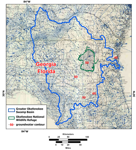
The sequence of carbonate rocks, although typically subdivided into the Upper Floridan aquifer, Middle confining unit, and Lower Floridan aquifer, are hydraulically connected (Miller, 1986) . In northeastern Florida and Georgia, the Lower Floridan aquifer contains fresh to brackish water, but in south Florida it is saline (Kinnaman & Dixon, 2011) . For the creation of the potentiometric surface of the Upper Floridan aquifer in Florida and Parts of Georgia, South Carolina, and Alabama for May-June 2010, Kinnaman & Dixon (2011) did not extend potentiometric contours in approximately the southern third of Florida (i.e., south of Charlotte, Glades, and Martin Counties) because brackish to saline water already present within the Upper Floridan aquifer in that area in 2010 affected the water density and water levels. Only locations of measured artesian pressure were indicated on the map in that area (Kinnaman & Dixon, 2011) .
Bacchus (2000) and Lines, Bernardes, He, Zhang, Bacchus, Madden, & Jordan (2012) summarized karst literature related to the Floridan aquifer system, including modern-day and relict sinkholes (also known as subsidence features) and the alignment of those depressional karst features along linear fractures, particularly at fracture intersections. Bacchus & Barile (2005) illustrated examples of non-linear karst conduits mapped in this aquifer system, including within the study area for this case study. Groundwater extractions in karst aquifers can result in induced recharge that dewaters the surficial aquifer and surface waters, including wetlands, in addition to saltwater intrusion from the coast, upconing of saline water from underlying, saline aquifer zones, and pirating water from other, adjacent basins, via those characteristic karst features. Groundwater extractions from the Floridan aquifer system also can result in the premature decline and death of trees and catastrophic wildfires due to the dewatering of the surficial aquifer through these karst features (Bacchus, 2000; Bacchus, 2007) . Barlow (2003) also addresses both saltwater intrusion and preferential flow associated with the aquifer system. This induced recharge from unsustainable groundwater withdrawals that drains surface waters is in addition to loss of base flow to those surface waters from groundwater withdrawals and anthropogenic capture of overland flow (also referenced as “stormwater”), as described in Basso & Schultz (2003) . Peek (1951) also describes the capture of natural discharge of ground water at Kissengen Spring by wells as one of the first observable examples in Florida. Anthropogenic capture of water from unsustainable groundwater withdrawals in karst aquifers also is known as induced recharge, inter-basin flow, and pirating of water.
Relict sinkholes also are known as paleosinkholes and are not confined to areas landward of the existing Atlantic Ocean and Gulf of Mexico shorelines associated with the regional Floridan aquifer system. In fact, the continental shelf is a drowned continuation of extensive karst areas onshore. Submarine sinkholes, indicating past sealevel low-stands, have been observed across the width of the continental shelf. Examples are shown in Figure 1 of Faught & Donoghue (1997) . Those sinkholes, in addition to paleochannels of streams, also occur in submarine portions of this karst aquifer system submerged by glacial sealevel rise, as illustrated in Figure 2 of Faught & Donoghue (1997) . Bacchus et al. (2014) provided examples of previously-documented relict sinkholes located in the portion of the Floridan aquifer system submerged by the Atlantic Ocean and Gulf of Mexico.
Faught & Donoghue (1997) used sub-bottom seismic data and bathymetry to identify buried sinkholes, including those which were marine-inundated, prehistoric archaeological sites, during their reconstruction of the Apalachee Bay paleodrainage system along the Florida’s northeastern Gulf of Mexico. Their study area included the possible submerged paleochannel of the Pinhook River located east of the submerged paleochannels of the St. Marks River and Stony Bayou and west of the submerged paleochannels of the karst-controlled Aucilla River and Ecofina River. Those paleochannels converged offshore as tributaries of the Paleo Ochlockonee River. Those marine-inundated paleofluvial systems are shown in Figure 5 of Faught & Donoghue (1997) . The linear alignment of depressional karst features identified as the submerged Aucilla Paleochanel was illustrated in the topographic mesh diagram included as Figure 7 in Faught & Donoghue (1997) .
Fractures in the north-Florida area of this karst aquifer system initially were mapped by Vernon (1951) . Approximately two decades later the Florida Department of Transportation (FDOT, 1973) mapped fractures in this aquifer system throughout Florida. Lines et al. (2012) described the differences between the data sources and scales used to create those two sets of fracture networks in Florida. Lines et al. (2012) also summarized preferential groundwater flow in the karst Floridan aquifer system and hydroperiod alterations. Our use of terminology related to karst aquifer systems and preferential groundwater flow is consistent with the terminology in Lines et al. (2012) , including definition of key terms from previously published sources included in Table 1 of Lines et al. (2012) .
Additional fractures in the south-Florida area of this regional aquifer system were shown in a draft report released by the US Army Corps of Engineers (USACOE, 2004) and were included in Volume 2 of a Final Environmental Impact Statement (EIS) by that agency a decade later. The extent of those three sets of fractures, previously mapped in Florida, are shown in Figure 3. Figure 2a of Xu et al. (2016) illustrated the mapped fractures in Florida, overlain by modern-day sinkholes, which are so numerous in some areas that they obscure the fractures.
Less extensive mapping of fractures has occurred in the Georgia portion of the regional Floridan aquifer system and other areas of Georgia. Examples of those mapped fractures in Georgia and preferential flow of ground water through those fractures include Brook (1986) , Brook & Allison (1986) , Brook, Carver, & Sun (1986) , Brook & Sun (1982) , Brook, Sun, & Carver (1988) , and Garcia, Brook, & Carver (1990) . An example of the density of fractures mapped within the Georgia portion of the Floridan aquifer system is provided by the fractures mapped by Brook & Allison (1986) in Dougherty County, Georgia. Those mapped fractures are shown in Figure 4b of Bacchus, Bernardes, Xu, & Madden (2015b) and Figure 3a of Xu et al. (2016) . We are not aware of similar efforts to map the locations, extent and density of fractures in the Georgia portion of the Greater Okefenokee Swamp Basin, including areas in southeast Georgia where mining is occurring and proposed.
Unfortunately, neither the regulation nor the management of ecosystems providing habitat for the survival and recovery of federally endangered and threatened species, or any other wildlife has considered the adverse impacts from preferential flow through fractures and other karst features from aquifer extractions and injections throughout the regional karst Floridan aquifer system. Examples of those adverse impacts are described by Xu et al. (2018) , for the federally endangered Florida panther (Felis concolor coryi), Bacchus et al. (2015a) for species that rely on environmentally sensitive near-shore waters, wetlands of the Greater Everglades Basin, and the entire regional karst aquifer system, and Bacchus et al. (2015b) for all of the federally endangered and threatened species and all other native wildlife within the portion of the regional karst Floridan aquifer system underlying the Coastal Plain of Georgia. In fact, those threats were not acknowledged in the online synopsis of the most recent Georgia State Wildlife Action Plan, provided by the Georgia Department of Natural Resources (GDNR, 2015a) , or the 262-page copy of the main plan (GDNR, 2015b) , or the Appendix F of that report, by the “Aquatic Habitat Technical Team” (GDNR, 2015c) , prepared by Albanese, McCurdy, and Straight.
1.3. Groundwater Declines in the Regional Floridan Aquifer System and Implications for the Species Dependent on That Regional Aquifer System for Survival and Recovery
The publication by Meinzer (1927) was one of the earliest and most extensive publications describing plants as indicators of groundwater discharge. Kohout & Kolipinski (1967) provided additional documentation of the fact that the distribution of plant and animal communities in nature rarely is random. They used data from their study of biological zonation related to groundwater discharge within the submerged extent of the Floridan aquifer system associated with Biscayne Bay, in Miami, Florida. This non-random distribution of plant and animal communities is based on factors governing the distribution of living organisms, including food sources and favorable surroundings, also known as the habitat for those communities. As an example, early evaluations of the distribution of near-shore organisms in southeast Florida documented what coastal fisherman in Florida had known for years—organisms are attracted to groundwater discharges (Kohout & Kolipinski, 1967) . Popenoe, Kohout, & Manheim (1984) , also emphasized the non-random distribution of solution features controlled by regional joint patterns in the regional karst Floridan aquifer system.
Popenoe et al. (1984) also provided examples of how the non-random, preferential flow of ground water through the karst Floridan aquifer system and submarine groundwater discharge (SGD), attracts large numbers of fish. One example those authors provided was a submarine spring offshore of Crescent Beach, Florida. That spring produced 2250 kilograms (5000 pounds) of red snapper (Lutjanus aya) to one fisherman in 1962 and 450 kg (1000 lb) of red snapper to another fisherman in 1968. By 1970, when a fluorescein dye sample was released in that submarine spring as a tracer, fresh groundwater discharge had ceased and the downward movement of the dye suggested saltwater intrusion into the Floridan aquifer was occurring at the site of the former spring, now just a submarine sinkhole, due to unsustainable groundwater extractions (Popenoe et al., 1984) .
Similar flow reversals were documented in 2008 and 2009 for the submarine Spring Creek, in the Gulf of Mexico, offshore of Wakulla County, Florida. Recorded salinities were as high as 30 parts per thousand (ppt) within the Spring Creek cave system both years due to excessive groundwater withdrawals from the Wakulla Springshed and high tides. The Wakulla Springshed extends into southwest Georgia, where extensive, unsustainable groundwater withdrawals from the Floridan aquifer system occur. The denser, salt water that enters the submarine spring conduits will remain until and unless a larger freshwater gradient is available (e.g., reduced groundwater withdrawals) to force the salt water out of those spring conduits (Kincaid, 2010; Kincaid, Meyer, & Day, 2012) .
A decade after the documented cessation of groundwater discharge from the submarine spring offshore of Crescent Beach, Florida and reversal of flow, with saline water flowing into that submarine spring (Popenoe et al., 1984) , the US Geological Survey (USGS) published the estimated potentiometric surface of the Tertiary Floridan aquifer system prior to development (e.g., groundwater withdrawals and mining), by Johnston, Krause, Meyer, Ryder, Tibbals, & Hunn (1980) . The following year, the USGS published a comparison extent of the potentiometric surface of the Tertiary Floridan aquifer system based on groundwater data available in 1980 (Johnston, Healy, & Hayes, 1981) .
Additional submarine depressional features in the Floridan aquifer system, which may be dewatered submarine springs, are described in Bacchus et al. (2014) . Those submarine depressional features included one west of Cape Sable, in the vicinity of where a high density of turtle grass (Thalassia testudinum Banks ex. König) was reported, suggesting that turtle grass may be an indicator species of submarine groundwater discharge (Bacchus et al., 2014: Site 9) . Rosenberry, Striegl, & Hudson (2000) described other plants indicative of focused groundwater discharge.
Extensive, non-random distribution of preferential flow and non-random discharge of ground water (including contaminated injected fluids), both characteristics of the regional Floridan aquifer system described in preceding examples, demand specific minimum requirements for scientifically valid evaluations of potential impacts to species and habitats. Specifically, these characteristics are not suited for study designs that involve standard randomized, haphazard, kriging, or grid approaches, as have been used for data collection and analysis in typical agency-funded field studies within the regional Floridan aquifer system. Bacchus et al. (2014) described the ramifications to the “Antidegradation Requirements” from the 1972 federal Clean Water Act (CWA, originally known as the Federal Water Pollution Control Act) of research and monitoring designs that fail to address the non-random groundwater characteristics of the regional Floridan aquifer system. The US Environmental Protection Agency’s (USEPA) Environmental Monitoring and Assessment Program (EMAP) for the Florida Keys National Marine Sanctuary was used as an example of research and monitoring designs that failed to consider focused groundwater discharges and large volumes of sewage effluent injected into the aquifer system daily as sources of pathogens, sulfide toxicity, and disruptions of natural salinity in that “protected” nearshore coastal area of the regional Floridan aquifer system that resulted in seagrass dieoff in Florida Bay.
2. Study Area
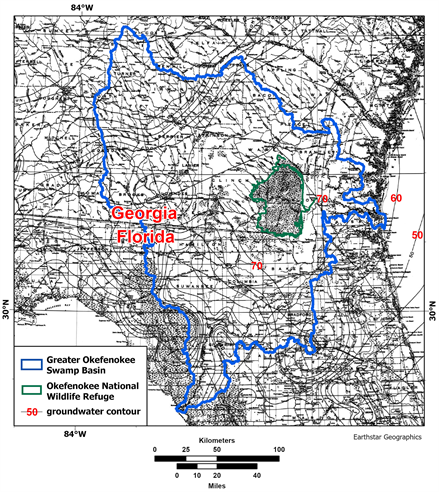
The Greater Okefenokee Swamp Basin study area is located in the northeast- Florida and southeast-Georgia portions of the regional Florida aquifer (Figure 1) and includes the majority of the existing and proposed mining in that portion of that regional karst aquifer system. That existing and proposed mining has had and will have similar groundwater impacts to the Floridan aquifer system and surface waters, including wetlands, as the mining activities described in Bernardes et al. (2019) . That study, however, focused only on flooding-related impacts of mining activities in the Santa Fe River (SFR) Basin. The Greater Okefenokee Swamp Basin was selected as the study area to address the adverse impacts of groundwater declines, including from mining, on surface waters in the Greater Okefenokee Swamp Basin that the examples of federally listed species addressed in Part 2 of this case study (Bacchus, Bernardes, & Madden, in press) rely on for their continued survival and recovery.
Eight river basins in Florida and Georgia, including the SFR Basin, comprise the Greater Okefenokee Swamp Basin. Figure 2 illustrates the locations of the eight river basins, the counties associated with those river basins, and the boundaries of the Okefenokee National Wildlife Refuge (ONWR) represented in the Greater Okefenokee Swamp Basin. Table 1 provides an alphabetical list of those eight river basins, the 15 counties in Florida, and the 26 counties in Georgia included in portions of the Greater Okefenokee Swamp Basin.
![]()
Figure 1. Extent of the Floridan aquifer system, from the Atlantic Ocean and Gulf of Mexico, and throughout Florida and the southeastern coastal plain of Mississippi, Alabama, Georgia, and South Carolina, and the Greater Okefenokee Swamp Basin study area in northeast Florida and southeast Georgia.
3. Methodology
3.1. Digital Boundaries, Images, and Other Data Obtained from Agencies and Other Sources
Digital boundaries for the landward extent of the regional Floridan aquifer system in Florida and in parts of Georgia, Alabama, and South Carolina were obtained from Bellino (2011) , while the landward extent for that regional aquifer system in Mississippi is consistent with Miller (1991) . The submarine boundaries of the regional Floridan aquifer system were digitized at the submerged boundaries of the continental shelf. Boundaries in digital format for the river basins comprising the Greater Okefenokee Swamp Basin were obtained from the USGS Watershed Boundary Dataset (WBD) at the HUC8 level (USGS, 2018) . Those eight river basins and HUC8 codes are provided in Table 1.
![]()
Figure 2. River basins comprising the Greater Okefenokee Swamp Basin study area, and boundaries of counties and the Okefenokee National Wildlife Refuge included in portions of the Greater Okefenokee Swamp Basin.
The source for Figures 1-3 was Esri, Maxar, GeoEye, Earthstar Geographics, CNES/Airbus DS, USDA, USGS, AeroGRID, IGN, and the GIS User Community. Figure 4 is Figure ES-1 from the 2013 Final AEIS (USACOE, 2013b) . Sources for Figure 5(a) and Figure 5(b) were Esri, Maxar, GeoEye, Earthstar Geographics, CNES/Airbus DS, USDA, USGS, AeroGRID, IGN, and the GIS User Community, Esri, HERE, Garmin, Intermap, Increment P Corp. ArcGIS Pro, Version 2.5.1 was used for georeferencing and all other manipulation of geospatial data. Georeferencing of potentiometric contour maps published by Johnston et al. (1980) and Johnston et al. (1981) to create Figure 5(a) and Figure 5(b) involved the ingestion of those maps into ArcGIS Pro, the identification of the projection used by those maps, the collection of control points and the application of a geometric transformation. Control point collection considered the identification of points over the image and the use of a reference grid with known coordinates. Thirty-three well-distributed points were collected over both potentiometric
![]()
Table 1. Eight river basins, 15 counties in Florida, and 26 counties in Georgia included in portions of the Greater Okefenokee Swamp Basin.
images. Points were used to compute a linear transformation with spatial error less than or equal to the thickness of a drawing line for those maps, which was approximately 350 meters, when projected on the ground.
The acquisition and methods for the initial mapped lineaments indicative of fractures in north Florida (Vernon, 1951) and mapped lineaments representing the most extensive fractures throughout the entire State of Florida (FDOT, 1973)
![]()
Figure 3. Proximity of the Greater Okefenokee Swamp Basin study area to the Peace River Basin and previously mapped fractures throughout Florida by FDOT (1973) , red diagonal lines; in northeastern Florida by Vernon (1951) , yellow diagonal lines; in southern Florida by USACOE (2004) , white diagonal lines; and in Dougherty County, Georgia by Brook & Allison (1986) , pink diagonal lines.
were described in Bacchus et al. (2014) , Bernardes et al. (2014) , and Lines et al. (2012) . The extensive networks of fractures in south Florida originally were from USACOE (2004) , but the vector data representing those networks of fractures were not available from the USACOE. Therefore, those networks of fractures were recreated by converting the analog file to a digital file, as described in Bacchus et al. (2015a) . All three of those fracture datasets, in addition to the previously mapped fractures by Brook & Allison (1986) , were included in Figure 3. Figure 8 includes fracture datasets previously mapped by FDOT (1973) , Vernon (1951) , and the USACOE (2004) .
The investigation of periods of below-average precipitation in Figure 6 and Figure 7 used 125 years of precipitation data beginning on January 1895 and ending on December 2019 provided by the Parameter-elevation Regressions on Independent Slopes Model (PRISM) Climate Group (PRISM, 2018a, 2018b) .
![]()
Figure 4. The geographic scope of the 2013 Final AEIS, delineated as the boundary of the CFPD, and the portions of watersheds, major rivers, and counties included within the scope boundaries, in addition to the areas of previous and ongoing phosphate mining and areas of proposed phosphate mine expansion (Figure ES-1 from USACOE, 2013b ).
Total monthly precipitation was analyzed using the boundaries of the Peace River Basin (WBDHU8 level) defined by the USGS (2018) . Total monthly precipitation was averaged for the Peace River Basin using Google Earth Engine (https://earthengine.google.com/) and WBD files. Time series analyses and the identification of climatological normals for the Peace River Basin included the computation of 30-year averages of monthly precipitation for three periods (1928-1957, 1958-1987, and 1988-2017).
3.2. Literature Reviews
Interdisciplinary literature reviewed for this case study included published and
(a)
(b)
Figure 5. Potentiometric surface for the Tertiary Floridan aquifer system in the study area: (a) prior to development (estimated) and (b) in 1980.
![]()
Figure 6. Average total monthly precipitation for the Peace River Basin (HUC03100101) from January 1895 to December 2019, with dashed gray line at 109.9 mm (4.3 in). representing the average total monthly precipitation for the basin during that period (109.9 mm).
![]()
Figure 7. Average total monthly precipitation for three 30-year periods (1928-1957, 1958- 1987, 1988-2017) for entire Peace River Basin (HUC03100101).
grey literature, in addition to legal case law and related legal publications. Specifically, hydrogeological literature related to preferential flow and declines in the regional, karst Floridan aquifer system, was reviewed, including surficial aquifers, particularly in Florida and Georgia and related to mining. Hydroecological literature also was reviewed, related to responses of anthropogenic alterations of ground water that result in degradation of the physical, chemical, and biological integrity of the nation’s waters by altering natural hydroperiods, thus jeopardizing provisions of the federal CWA and the Antidegradation requirements based on the CWA clause to “restore and maintain the chemical, physical and biological integrity of the Nation’s waters.” Aspects of the Endangered Species Act (ESA) also were reviewed, including published and grey literature from and funded by agencies implementing those laws, in addition to rulings in related federal court cases and publications related to those cases. This case study also included excerpts from a letter to the editor of a local newspaper from Dennis Price, the Professional Geologist with personal scientific knowledge about mining activities directly related to the early stages of phosphate mining at White Springs, in the Greater Okeffenokee Swamp Basin. Also included are transcribed excerpts, by the lead author, of a Colloquium at the University of Georgia (UGA) where Dr. Robert Holt, Hydrologist for Twin Pines Minerals, LLC (also known as Twin Pines), presented his methodology and data for the heavy mineral sands mining (also known as titanium mining) that is proposed east of the Okefenokee Swamp, to scientists for their review and for him to respond to questions from those scientists. Those excerpts were analyzed as part of this case study.
4. Results and Discussion
This section provides examples of why the USEPA and other federal, state, regional, and local agencies involved in management and regulatory decisions regarding natural resources and federally listed species in the southeastern US, should consider the Southeastern Coastal Plain Ecoregion as the single ecoregion within the extent of the regional Floridan aquifer system. This is required particularly for the management of all mining and other activities that involve groundwater withdrawals and other anthropogenic alterations of ground water because the Southeastern Coastal Plain Ecoregion is underlain entirely by this regional karst aquifer system. Support for that conclusion is based on five factors. The first factor is extensive published literature, including the 1994 USGAO Report for Ecosystem Management (USGAO, 1994) . The second factor is the similarities between ecosystem responses within the Greater Okefenokee Swamp Basin study area and ecosystem responses in comparison areas within the extent of the regional Floridan aquifer system. The third factor is the failure of the USEPA and the USACOE to conduct a comprehensive Areawide Environmental Impact Statement (AEIS) for mining in the Greater Okefenokee Swamp Basin, similar to the required, but deficient AEIS those agencies conducted for mining that also was similar in nature within the boundaries of the Central Florida Phosphate District (CFPD) geographic scope of that 2013 AEIS, which included the headwaters of Peace River Basin (USACOE, 2013b) . The fourth factor is the degradation of the physical, chemical, and biological integrity of the nation’s waters that have occurred within the regional Floridan aquifer system, in violation of the CWA of 1972. That particularly is true because the physical, chemical, and biological integrity of the nation’s waters are required for the survival and recovery of federally listed species and their habitat. The fifth factor is the further degradation of the physical, chemical, and biological integrity of the nation’s waters that will occur, particularly in the Greater Okefenokee Swamp Basin, under the two USEPA rules that were adopted in 2020 and currently are being challenged in court, if those rules are upheld.
4.1. Terminology and Objectives
4.1.1. Terminology
Addressing Groundwater Impacts Under the CWA and the National Environmental Policy Act of 1969 (NEPA)—The analyses of this case study focus on mining activities that meet Section 404 criteria of the CWA and involve groundwater withdrawals and the discharge of dredged or fill material within the extent of the regional karst Floridan aquifer system. Those mining projects result in hydrologic alterations of the physical, chemical, and biological integrity of the nation’s waters, which cause irreversible destruction of habitat that is essential and critical for the survival and recovery of federally listed species, such as the federally endangered and threatened marine and aquatic species addressed in Part 2 of our case study (Bacchus et al., in press) . Examples of those hydrologic alterations are provided in subsections of the Results and Discussion, below and all of the types of mining discussed in this case study and the companion case study by Bacchus et al. (in press) results in “significant impacts.” Therefore, none of these mining activities meet the criteria of a “finding of no significant impact” (FONSI) under §230.9 “Categorical Exclusions” for the USACOE.
Although groundwater withdrawals are not regulated under the CWA, for mining activities that meet Section 404 criteria of the CWA and involve the discharge of dredged or fill material and groundwater withdrawals, all of the direct, indirect, and cumulative impacts of those mining activities (including the impacts of groundwater withdrawals) must be considered before CWA permits are issued for those projects. Because the adverse direct, indirect, and cumulative impacts of those mining activities are extensive and widespread, it is essential that the USEPA and the USACOE initiate a regional AEIS to ensure agency consideration of all of those adverse impacts, particularly for mining activities in the Greater Okefenokee Swamp Basin study area, where extensive mining already has occurred and is expanding, with more extensive mining proposed. Compliance with the NEPA (42 United States Code (USC) 4321 et seq.), which was signed into law on January 1, 1970, also requires that activities based on federal actions (e.g., the types of mining described in this case study and the companion case study by Bacchus et al. (in press) , must consider the direct, indirect, and cumulative adverse impacts of those activities. Groundwater alterations from these types of mining include both indirect and cumulative adverse impacts. Title II of the NEPA established the Council on Environmental Quality (CEQ), which describes direct, indirect, and cumulative impacts in extensive detail in its 120-page document titled “Considering Cumulative Effects under the National Environmental Policy Act” released in January 1997. The following excerpts from 40 Code of Federal Regulation (CFR), Part 1508, however, provide a succinct description of those three types of impacts:
“Sec. 1508.8 Effects.
‘Effects’ include:
(a) Direct effects, which are caused by the action and occur at the same time and place.
(b) Indirect effects, which are caused by the action and are later in time or farther removed in distance, but are still reasonably foreseeable. Indirect effects may include growth inducing effects and other effects related to induced changes in the pattern of land use, population density or growth rate, and related effects on air and water and other natural systems, including ecosystems.
Effects and impacts as used in these regulations are synonymous. Effects includes ecological (such as the effects on natural resources and on the components, structures, and functioning of affected ecosystems), aesthetic, historic, cultural, economic, social, or health, whether direct, indirect, or cumulative. Effects may also include those resulting from actions which may have both beneficial and detrimental effects, even if on balance the agency believes that the effect will be beneficial.”
“Sec. 1508.7 Cumulative impact.
‘Cumulative impact’ is the impact on the environment which results from the incremental impact of the action when added to other past, present, and reasonably foreseeable future actions regardless of what agency (Federal or non-Federal) or person undertakes such other actions. Cumulative impacts can result from individually minor but collectively significant actions taking place over a period of time.”
Addressing Groundwater Impacts Under the ESA—There also is legal precedence requiring the US Fish and Wildlife Service (USFWS) to consider the adverse impacts of groundwater withdrawals on federally endangered and federally threatened species under the ESA. The example provided here involved unsustainable groundwater withdrawals from the Edwards Aquifer in Texas. Like the Floridan aquifer system, the Edwards Aquifer is a karst aquifer that is essential for the survival and recovery of numerous federally endangered and threatened aquatic and other species. For example, the Edwards Aquifer, which is the “source of water for San Antonio, Texas, contributes surface water flow in the Guadalupe River through Comal and San Marcos Springs, both of which are home to endangered aquatic species, including the fountain darter” (Votteler, 1998) . That publication also provided the history of legal action taken by the Sierra Club against Bruce Babbitt, Secretary of the US Department of the Interior, pursuant to the ESA, in the following relevant excerpts, including concerns expressed by the USGS regarding saltwater intrusion from those groundwater withdrawals:
“In 1993, a U.S. district court ruled that the Secretary of the Interior allowed takings under the Endangered Species Act (ESA) by not ensuring adequate flows from the Springs…
During a second ESA suit alleging that groundwater pumpers were causing takes of endangered species, the U.S. district court ordered the implementation of a plan to reduce pumping from the Aquifer…” (page 845)
“The possibility of saline water encroachment has been a concern since a drought in the 1950s, when residents reported that some freshwater wells on the southern edge of the Aquifer experienced an intrusion of highly mineralized water.”
“31Robert Perez, U.S. Geological Survey, Potential for Updip Movement of Saline Water in the Edwards Aquifer, San Antonio, Texas, Report 86-4032 (1986).” (page 850)
“At Comal and San Marcos Springs, one threatened and seven endangered species, which live in the Springs’ openings and in the rivers and lakes originating from the Springs, have been listed by USFWS… Critical habitat has been designated only at San Marcos Springs.” (page 851)
“A flow rate of 200 cubic feet per second (cfs) at Comal Springs, below which a taking can occur, is the tripwire for ESA litigation.42” (based on USGS data)… The Guadalupe River also provides freshwater inflows for San Antonio Bay, winter home of the endangered whooping crane (Grus americana).” (page 853)
“In 1991, the Sierra Club, along with Professor Clark Hubbs (Professor Emeritus of Zoology, University of Texas at Austin), filed a suit in the U.S. District Court in Midland, Texas against the Secretary of the Interior and the USFWS, alleging that the Secretary of the Interior had allowed takings of endangered species by not ensuring water levels in the Edwards Aquifer adequate to sustain the flow of Comal and San Marcos Springs… On February 1, 1993, Judge Lucius Bunton ruled in favor of the plaintiffs.56 The court required the USFWS to determine the springflow requirements to avoid a taking or jeopardy of the listed species in both Springs.57” (page 854)
“Sierra Club v. Babbitt was eventually resolved in February 1996, after USFWS published a recovery plan for the threatened and endangered species at Comal and San Marcos Springs, and the appellate court concluded that all action required by Judge Bunton’s 1993 amended judgment had been fulfilled.83”
“83The recovery plan acknowledges that the key issue to survival of the listed species is the conservation of the aquatic ecosystems at Comal and San Marcos Springs, as well as the Aquifer itself. REVISED RECOVERY PLAN, supra note 34, at 51.” (page 864)
“On September 14, 1998, the Environmental Defense Fund notified EAA of its intent to sue over violations of the ESA as a result of EAA allowing pumping from the Aquifer ‘in quantities great enough so as to reduce springflows at Comal and San Marcos Springs to the point that listed species are harmed and harassed.’130 On September 24, 1998, a three judge panel of the U.S. Fifth Circuit Court of Appeals ruled on an appeal of Sierra Club v. Glickman. Among the Court of Appeals findings was the determination that the ESA requires federal agencies not only to avoid actions that jeopardize listed species, but also that federal agencies are required to consult with USFWS and develop programs to conserve endangered species consistent with the agency’s real authority over species-related issues.131 The State District Court for Travis County voided EAA’s rules for granting permits as well as the Critical Period Management Plan.132…” (pages 873-874)
“When the State was unable to regulate the Aquifer, the federal government became the focus for managing withdrawals because of the effect of diminished springflow upon federally listed endangered species. When USFWS did not develop and implement a recovery plan for the endangered species, the authority for limiting withdrawals became the U.S. district court.” (page 877)
Figure 2 from Votteler (1998) is a graph that shows the mean daily cfs flow for Comal Springs from January 1990 through December 1998. Horizontal lines on that graph shows the 200 cfs level established as the minimum daily flow to prevent “take” of federally listed aquatic species and the 150 cfs level established as the minimum daily flow to prevent “jeopardy” of federally listed aquatic species. Votteler (1998) also provides the following footnote with the definitions of “take” and “jeopardy” from the ESA:
“39‘Take’ means ‘to harass, harm, pursue, hunt, shoot, wound, kill, trap, capture, or collect, or to attempt to engage in any such conduct.’ Endangered Species Act of 1973, 16 U.S.C. § 1532 (19) (1994). A ‘take’ is an event that may pertain to as few as one individual of the species. The term ‘jeopardy’ refers to a situation where the survival of the entire species is in peril.” (page 852)
The Amended Findings and Conclusions and the Amended Judgement for the Sierra Club v. Babbitt case were filed by Bunton III (1993a, 1993b) respectively on May 26, 1993. That case involed three groups of parties, with the third group including those eight aligned as amici curiae. Six of the eight comprising the amici curiae group were identified collectively in the Amended Findings and Conclusions as “Industrial Water Users on the Lower Guadalupe River Association” (IWUA). Examples of those industrial water users included: Occidental Chemical Corp., E.I. Dupont De Nemours & Company, Inc., BP Chemicals, and Union Carbide Chemicals and Plastics Company, Inc. The fact that the first two corporations included in that list of six industrial water users of the Edwards Aquifer also are addressed in this case study and the companion case study by Bacchus et al. (in press) probably is not coincidental, considering the significant volume of the available water supply used by the mining activities of those two corporations. The issues addressed in the Amended Findings and Conclusions (Bunton III, 1993a) included, but were not limited to the following:
“Endangered Species Act Specifics
Takes of and Jeopardy to Fountain Darters
Takes of and Jeopardy to Other Animal Species at Comal and San Marcos Springs and in the Edwards
Destruction or Adverse Modification of Critical Habitat of Texas Wild-rice, Damage to or Destruction of Texas Wild-rice, and Jeopardy to Texas Wild-rice
Failure to Develop a Recovery Plan for the Comal Springs Ecosystem and Species
Failure to Develop a Recovery Plan for the Texas Blind Salamander
Failure to Implement Essential Features of the San Marcos Recovery Plan Dealing with the Greatest Threat
The Federal Defendants Have Unlawfully Refused or Unreasonably Delayed Implementing Recovery Measures to Protect Minimum Springflow Quantities”
The next to the last issue listed above included “Define Minimum Springflow” and “Consultation.” It is important to note that the Section 404 state mining permit issued to Chemours/DuPont by the Florida Department of Protection (FDEP) in July 2022, for heavy mineral sands mining in the Greater Okefenokee Swamp Basin did not include a USFWS consultation with FDEP or a Biological Opinion issued to FDEP by the USFWS, as described in this case study.
Similar to the Floridan aquifer system and its springs, the karst Edwards Aquifer was described in those Amended Findings of Facts and Conclusions as, “porous and complexly faulted with numerous fractures and solution cavities. The movement of water through the aquifer, except in general terms, is largely undefined…” and “But for human withdrawals, natural discharge from the Edwards at the Comal and San Marcos Springs would likely be stable.” Also important was the following finding, “…In dry seasons, pumping is expectedly higher, especially spring, summer, and drought years.” (Bunton III, 1993a) .
Those 1993 Amended Findings and Conclusions also include the following excerpts describing that karst aquifer system, which also apply to the karst Floridan aquifer system (emphasis added):
“37. If current levels of withdrawals are allowed to continue without reduction, endangered and threatened species will be taken, damaged, or destroyed; their designated critical habitat destroyed or adversely modified; and their continued existence severely jeopardized during dry periods or relatively mild droughts.” (page 13)
“38. Dry periods and relatively mild droughts occur with some frequency in Texas.” (page 13)
“40. The Edwards is overdrafted: meaning, more water is withdrawn every year than its ‘firm yield’ in the drought of record.” (page 13)
“53. The surest and most prudent method of ensuring the inexistence of significant adverse water quality impacts, due to pumping from the Edwards, is to limit pumping to the extent necessary to maintain adequate, continuous natural springflows from the Comal Springs at all times. Uncertainties of human knowledge prevent reducing the Edwards level any lower.” (page 17)
“91. Maintaining springflow at Comal Springs is essential to preventing jeopardy because ‘it is hard to have an aquatic ecosystem without any water’…” (page 32)
“97. The direct human cause of low springflows at Comal Springs and resulting takes of and jeopardy or near jeopardy to Fountain Darters in 1989 and 1990 was excessive pumping from the Edwards.”
The preceeding excerpts from the 1993 Amended Findings and Conclusions focus on the hydrologic aspects of Bunton III (1993a) , while Part 2 of this case study (Bacchus et al., in press) focuses on the ESA aspects of those 1993 Amended Findings and Conclusions for Bunton III (1993a) . The reduced flow of the springs and riverine ecosystems resulting from unsustainable groundwater withdrawals from the karst Edwards aquifer system is similar to the reduced flow and dewatering of springs and riverine ecosystems associated with the regional karst Floridan aquifer system, including within the Greater Okefenokee Swamp Basin, in this case study. The difference is that the primary activities dewatering the Floridan aquifer system in the Greater Okefenokee Swamp Basin are mining activities, specifically mining activities for heavy mineral sands and phosphate mining.
Approximately three decades of expansion by these mining activities in the regional karst Floridan aquifer system, particularly in the Greater Okefenokee Swamp Basin, has occurred since the legal action was taken in Sierra v. Babbitt for the failure of the USFWS to protect federally endangered and threatened aquatic species from unsustainable groundwater withdrawals from the karst Edwards Aquifer in Texas. Despite that fact, no action has been taken by the USFWS to protect the federally endangered and threatened aquatic and marine species from similar unsustainable groundwater withdrawals from the regional Floridan aquifer system, particularly those associated with the Greater Okefenokee Swamp Basin. Part 2 of this case study (Bacchus et al., in press) addresses examples of those species associated with the Greater Okefenokee Swamp Basin.
The flow rate of “200 cubic feet per second (cfs),” identified in Votteler (1998) as the flow level designated as the minimum flow, below which unpermitted “take” of federally listed species would occur, is comparable to approximately 129.26 million gallons per day (MGD). To put that minimum flow in perspective, the permit for water use issued by the Suwannee River Water Management District (SRWMD) for the phosphate mining at White Springs, in the Greater Okefenokee Swamp Basin allows an “average permitted use of 94.65 MGD” (358 million liters per day), according to Farrell (2011) . That average daily amount is equivalent to 73% of that total flow determined to be the minimum flow to prevent “take” of federally listed species in that Edwards Aquifer case.
Describing the Most Extensive Type of Mining in the Greater Okefenokee Swamp Basin—The mining of Trail Ridge in the Greater Okefenokee Swamp Basin study area, being conducted and proposed for further expansion by DuPont/Chemours/Twin Pines, has been referenced by those mining companies as “titanium” mining, “heavy mineral sands” mining and “heavy mineral” mining interchangeably. Little specific information has been provided in the limited regulatory permits that have been required, particularly in Florida, regarding exactly what natural resources are being extracted and removed for industry profits as a result of that mining. Apparently, that problem results from the failure of the regulatory agencies and municipalities to require the mining industry to provide that information in applications for approval of that mining. In this case study and the companion case study by Bacchus et al. (in press) that mining of Trail Ridge in northeast Florida and southeast of Georgia consistently references that mining as “heavy mineral sands mining,” except when referencing citations that use the specific terminology “titanium” mining.
Describing the Companies Associated with the Most Extensive Type of Mining in the Greater Okefenokee Swamp Basin—The mining activities associated with Trail Ridge, south of the Okefenokee Swamp (in northeast Florida), that have become the most extensive type of mining in the Greater Okefenokee Swamp Basin, reportedly were initiated in Starke, Florida, in approximately 1948 or 1949 by DuPont de Nemours, Inc. (known as DuPont). Shortly after those mining activities were initiated, two lakes mysteriously dried up, according to Sue Spencer, wife of the deceased first engineer involved in those titanium- mining activities (Jackson, 1997) . That mining continued to be conducted by DuPont until an internal change occurred in that corporation. Specifically, a news release by DuPont on July 1, 2015 (DuPont, 2015) announced the completed creation of DuPont’s spin-off company, “The Chemours Company” (known as Chemours). Chemours, is an American chemical company, with its corporate headquarters in Wilmington, Delaware, US (Fortune, 2018) . Chemours has assumed various liabilities arising from lawsuits against DuPont ( Chemours, 2015 , see “Risk” Section, pp. 21-37).
The permits originally issued by Florida agencies to DuPont for the mining of Trail Ridge, south of the Okefenokee Swamp, eventually were changed to reflect Chemours as the permittee. Additionally, the FDEP permits and warning letters for violations associated with those Trail Ridge mining activities have been issued to Chemours under various modifications of that name. For example, the permit issued on June 29, 2017 by FDEP to Chemours for mining activities associated with Trail Ridge was issued under the name “The Chemours Company TT LLC” (FDEP, 2017) . Less than a year later, a warning letter was issued on March 23, 2018 by FDER to Chemours under the name “The Chemours Company FC, LLC” (FDEP, 2018) . The “LLC” reference following the “The Chemours Company” is the abbreviation for “Limited Liability Company.”
That 27-page warning letter was issued to Chemours by FDEP for mining activities in northeast Florida, associated with Trail Ridge, in Baker, Bradford, Clay and Duval Counties. That warning letter included those mining activities being handled by Twin Pines, despite the fact that Twin Pines was not identified in the permit as one of the permittees. That warning letter put Chemours on notice that “A permit modification to include Twin Pines in the Industrial Wastewater permit was not obtained prior to beginning operation.” That warning letter also stated, “Twin Pines area needs to be added to IW permit—to include monitoring and inspecting requirements.” A search for documents subsequent to that official warning letter failed to identify any FDEP permits that included Twin Pines as one of the named permittees for that Trail Ridge mining, despite the fact that violations by Twin Pines were referenced under the permit held by Chemours in 2018. During the same approximate time frame as those mining-related violations by Twin Pines described in that FDEP’s 2018 warning letter, the same Twin Pines company applied to the USACOE for a permit to mine Trail Ridge east of the Okefenokee Swamp in southeast Georgia.
In summary, the adverse impacts of the mining activities in northeast Florida, that originally were initiated by DuPont, and DuPont’s state permits for that mining were transferred to Chemours, and subsequent warning letters for those mining activities identified permit violations by Chemours and Twin Pines (despite Twin Pines not being named as a permittee for those mining activities), are intertwined and inseparable. Therefore, those mining activities are referenced in this case study and in the companion case study by Bacchus et al. (in press) as “DuPont/Chemours,” “Chemours/DuPont” and “DuPont/Chemours/Twin Pines.” Multiple Freedom of Information Act (FOIA) requests to the USACOE failed to produce any federal permits that were issued to DuPont/Chemours for those mining activities associated with Trail Ridge in northeast Florida by DuPont/ Chemours.
4.1.2. Objectives of This Case Study
The first objective of this case study was to evaluate the effectiveness of the designated ecoregions in the US Southeastern Coastal Plain Physiographic Province Region, that were established in response to the 1994 USGAO (1994) report, for improving management of the nation’s natural resources. Those results and related discussions are provided in subsections 4.2. through 4.5., below, and include evaluations of the Peace River Basin and Cumberland Island as comparisons to the Greater Okefenokee Swamp Basin study area. The second objective of this case study was to identify lack of compliance with the CWA and ESA associated with the mining activities considered in this case study that have occurred in the past and still are occurring within the extent of the regional Floridan aquifer system, which also should be considered as the Southeastern Coastal Plain Ecoregion. The third objective of this case study was to identify some of the relevant deficiencies in the previous AEIS that was conducted within the boudaries of the CFPD geographic scope of that 2013 AEIS, which included the headwaters of Peace River Basin, and portions of seven other drainage basins (USACOE, 2013b) . That 2013 AEIS also considered only one of the types of mining addressed in this case study, rather than the entire mining industry in the ecoregion. Those and other deficiencies that occurred in that 2013 AEIS must be avoided in the AEIS conducted for the Greater Okefenokee Swamp Basin, so that all of the adverse impacts from the rapidly expanding mining in the Greater Okefenokee Swamp Basin are addressed.
4.2. Extent of the Karst Floridan Aquifer System within the Southeastern Coastal Plain Physiographic Province Region as the Southeastern Coastal Plain Ecoregion
The Floridan aquifer system underlies the entire State of Florida and the remaining US Southeastern Coastal Plain Physiographic Province Region of Mississippi, Alabama, Georgia, and South Carolina (Bellino, 2011; Miller, 1991) . The submarine portion of this regional karst aquifer system extends from the present- day coastlines of those states, under both the Atlantic Ocean and the Gulf of Mexico, to the edge of the continental shelf (Figure 1). Figure 1 also shows the location and extent of the Greater Okefenokee Swamp Basin study area within the north-central regional Floridan aquifer system. The US Southeastern Coastal Plain Physiographic Province Region is shown for the eastern four of those five states in ( Miller, 1990 , Figure 4, with the base modified from the 1970 USGS National Atlas).
On August 16, 1994, the US Government Accountability Office (USGAO) released a report titled “ECOSYSTEM MANAGEMENT—Additional Actions Needed to Adequately Test a Promising Approach” (USGAO, 1994) . That report recommended the identification of ecoregions throughout the US for improving management of the nation’s natural resources. Excerpts from that 1994 USGAO report, summarizing the purpose, background, results, additional actions needed, impediments, recommendations, and agency comments, are provided in Appendix B. Ten years after that USGAO report was released, additional, updated information was provided in a publication by one of the federal-agency leaders who worked on identifying ecoregions for the US (Omernik, 2004) . Those ecoregion designations extended into Canada, for a consistent approach to natural resource management for North America by the US and Canada. A group called the National Interagency Technical Team (NITT) was formed to address the problems identified by the USGAO (1994) report, by developing, a common geographic framework of ecological regions to be used by all of the resource management agencies (Omernik, 2004) . Relevant facts, additional background, and related questions and information regarding the use of ecoregions to improve natural resource management are provided in Appendix C, which includes confirmation that references to aquatic ecosystems within ecoregions includes estuarine and marine ecosystems.
The USEPA provides online copies of those designated ecoregions for downloading, at three levels, ranging from Level I, as the most inclusive level, and lower levels being more segmented (USEPA, 2022a) . The USEPA also provides online copies of Level III ecoregion designations by USEPA Regions (USEPA, 2022b) . The focus of this paper is the ecoregion designations associated with the extent of the Floridan aquifer system, which is contained within USEPA’s Region 4. The Level III Ecoregion Classification for USEPA Region 4 subdivides that regional karst aquifer system into the following three Ecoregions, from north to south, respectively: 64—Southeastern Plains; 75—Southern Coastal Plain; and 76—Southern Florida Coastal Plain. We provide support for treating those three subdivisions as one ecoregion, the Southeastern Coastal Plain Ecoregion, which coincides with both the terrestrial and submarine extent of the regional, karst Floridan aquifer system.
Those three, segmented USEPA Level III ecoregions suggest that the USEPA ignored the findings of Meinzer (1927) , as one of the earliest and most extensive publications describing plants as indicators of the presence of ground water. Also apparently ignored were the findings of the exceptional research by Kohout & Kolipinski (1967) , providing additional documentation that the distribution of plant and animal communities in nature rarely is random and that biological zonation was related to groundwater discharge within the submerged extent of the Floridan aquifer system and that organisms are attracted to groundwater discharges.
Consolidation of those three USEPA Level III ecoregions into a single ecoregion first is based on the fact that the regional Floridan aquifer system underlies all three of those subdivisions and is characterized throughout the entire extent by karstic preferential flow. As a result, all terrestrial and aquatic (i.e., freshwater, estuarine, and marine) ecosystems in the entire Southeastern Coastal Plain Ecoregion respond similarly to the same human impacts to the natural resources (e.g., mining and groundwater withdrawals). Second, the historic adverse anthropogenic impacts to the regional Floridan aquifer system already have jeopardized the survival and recovery for both animals and plants native and endemic to the Southeastern Coastal Plain Ecoregion, including the degradation and destruction of essential and critical habitat for the survival and recovery of federally endangered and federally threatened species (Bacchus, 1995a, 1995b, 1997a, 1997b, 1999, 2000, 2006, 2007; Bacchus, Archibald, Britton, & Haines, 2005; Bacchus, Archibald, Brook, Britton, Haines, Rathbun, & Madden, 2003; Bacchus & Barile, 2005; Bacchus, Bernardes, Jordan, & Madden, 2014; Bacchus, Bernardes, Xu, & Madden, 2015a, 2015b; Bacchus, Hamazaki, Britton, & Haines, 2000; Bacchus, Masour, Madden, Jordan, & Meng, 2011; Bernardes, He, Bacchus, Madden, & Jordan, 2014; Bernardes, Manglass, Bacchus, & Madden, 2019; Lines, Bernardes, He, Zhang, Bacchus, Madden, & Jordan, 2012; Miller, Bacchus, & Miller, 1993; Xu, Bernardes, Bacchus, & Madden, 2016; Xu, Bernardes, Bacchus, & Madden, 2018) . Therefore, this extensive published literature, which includes summaries of historic groundwater declines and resulting ecosystem declines from lack of adequate management of natural resources throughout the Southeastern Coastal Plain Ecoregion, also implies that any additional adverse impacts to this regional aquifer system will result in further degradation of this overlying ecoregion and further threaten the survival and recovery of the federally threatened and endangered species that rely on this ecoregion. Third, the terrestrial extent of this consolidated Southeastern Coastal Plain Ecoregion is similar in size to that of the USEPA Level III Ecoregions designated as “27— Central Great Plains” and “65—Southeastern Plains,” as shown in the “Level III Ecoregions of the Conterminus United States” map insert dated 2002, from USEPA (2022b) , confirming that the aerial extent of the Southeastern Coastal Plain Ecosystem is consistent with other ecoregions established in the US by the USEPA. The entire extent of the Southeastern Coastal Plain Ecosystem, including the marine and estuarine extent, coincides with the entire extent of the regional Floridan aquifer system shown in Figure 1.
4.3. The Peace River Basin as a Comparison Area in the Southwest of the Southeastern Coastal Plain Ecoregion
Achieving the objectives of this case study was facilitated by evaluating adverse impacts from unsustainable, irreversible groundwater withdrawals and subsequent surfacewater alterations from mining activities in the Peace River Basin, as a comparison for similar unsustainable groundwater withdrawals and subsequent surfacewater alterations from mining activities in the Greater Okefenokee Swamp Basin study area. The similarity in significant declines of the potentiometric surface of the Floridan aquifer system in the Peace River Basin and the Greater Okefenokee Swamp Basin, resulting from unsustainable groundwater withdrawals from that aquifer that extends beyond the surfacewater boundaries of the basin via fractures and other karst conduits, also facilitates this comparison. Figure 3 illustrates the proximity of the Greater Okefenokee Swamp Basin study area to the Peace River Basin, in addition to the locations of the previously mapped fractures in the Florida and Georgia parts of the Southeastern Coastal Plain Ecoregion. Figure 4 is from the 2013 Final AEIS and shows the boundary for the CFPD that was used as the “geographic scope” for that AEIS, outlined in yellow. That figure also shows the boundaries of eight “watersheds” (known as “drainage basin boundaries” for the USGS for Hydrologic Unit Classification (HUC) coding system), outlined in green ( Figure ES-1 of USACOE, 2013b ). Those watersheds, which are included in part within the CFPD boundary, are identified as follows in that figure from the 2013 Final AEIS (in alphabetical order):
Alafia River Watershed (including the headwaters)
Hillsborough River Watershed
Little Manatee River Watershed (including the headwaters)
Manatee River Watershed (including the headwaters)
Myakka River Watershed (including the headwaters)
Peace River Watershed (including the headwaters)
Southern Coastal Watershed
Withlacoochee River Watershed
Note the similar aerial extent of the Greater Okefenokee Swamp Basin and the geographic scope of the CFPD used in the 2013 Final AEIS, despite the fact that geographic scope did not include the entire drainage basins for any of the nine named “watersheds” adversely effected by the proposed mining projects evaluated in that 2013 Final AEIS, that was conducted by both the USACOE and the USEPA (USACOE, 2011) . Also note that the references in the legend of Figure 4 to “Restored and Preservation/Conservation Areas” is misleading because restoration, preservation and conservation, as well as mitigation, of wetlands and other natural habitat in areas associated with mining is not possible because of the irreversible hydrologic alterations, as described in this case study and other publications, such as Bacchus (2006) , Bacchus et al. (2011) , and Bernardes et al. (2014) . Although the Greater Okefenokee Swamp Basin includes eight sub-basins ( Figure 2 and Table 1), the Peace River Basin includes nine sub-basins. Figure 4 ( Figure ES-1 of USACOE, 2013b ) does not show those nine sub-basins within the Peace River Basin that are identified by the USGS HUC coding system for drainage Basin boundaries, but that figure does show the portions of the counties included in the boundaries of the CFPD.
4.3.1. Deficiencies of the AEIS Scope for the Mining Industry in the Peace River Basin
Concerned citizens and non-profit organizations had requested an AEIS repeatedly and unsuccessfully for years to address the adverse impacts of all mining, not only in the Peace River Basin, but throughout the extent of the regional Floridan aquifer system. Agency support for that AEIS finally was provided in a letter dated March 10, 2010, from the USEPA Region 4 Headquarters to the USACOE Jacksonville Office, acknowledging that the USEPA was “willing to serve as a ‘cooperating agency’” for that AEIS (USEPA, 2010) . The first paragraph of that four-page letter stated, in part, “[As] you know, EPA has long advocated that an Area Wide EIS be developed by the Jacksonville District, U.S. Army Corps of Engineers (COE) for the environmentally sensitive mining region.” The second paragraph of that letter identifies that, “The Area Wide EIS serves to evaluate overall or area-wide impacts of an industry or region…” The third page of that letter even acknowledges one of the commonalities of the mining industry that, “[M]ining activities create large berms or stacks of excavated overburden within the floodplain” ( USEPA, 2010 , emphasis added). Also, despite that request for an AEIS from the USEPA to evaluate the impacts of the mining industry in the region, the scope of the AEIS was confined, arbitrarily, only to: a) one type of mining (e.g., phosphate mining) in the expanding mining industry and b) only part of a region. Specifically, that 2013 Final AEIS was confined only to portions of the “Peace River Watershed” (also known as the Peace River Basin) and portions of the other eight watersheds that extend into the CFPD, none of which are “regions,” rather than to the regional Floridan aquifer system, which is consistent with the Southeastern Coastal Plain Ecoregion. All other types of mining in the mining industry that were expanding at that time within the regional Floridan aquifer system and the Southeastern Coastal Plain Ecoregion, and which result in similar irreversible adverse impacts also were ignored in that AEIS. That deficiency occurred despite the fact that those other types of mining also altered the physical, chemical, and biological integrity of the nation’s waters and resulted in irreversible destruction of habitat that is essential for the survival and recovery of federally listed species. More than a decade after that 2010 letter was sent from the USEPA to the USACOE, those federal agencies still have not conducted a true “regional” AEIS to evaluate the impacts of the mining industry on the “environmentally sensitive mining region” of the regional Floridan aquifer system and the Southeastern Coastal Plain Ecoregion, or even of the equally “environmentally sensitive” Greater Okefenokee Swamp Basin.
4.3.2. Groundwater Withdrawals for Phosphate Mining in the Peace River Basin Not Considered in the AEIS
The complete dewatering of the Kissengen Spring and upper tributary of the Peace River in Polk County, Florida in 1950 from phosphate mining was summarized in Part 2 of our case study (Bacchus et al., in press) , with accompanying photographs of the historical uses of that spring, as well as photographs of the dewatered spring and upper Peace River, in the Peace River Basin. This case study provides a synopsis of the more recent expansion of phosphate mining in the Peace River Basin following the documentation of the cause of that dewatering of both Kissengen Spring and the upper tributary of the Peace River, including more recent expansion of phosphate mining in the Peace River Basin. Although the proposed expansion of phosphate mining by The Mosaic Company (Mosaic) was the sole focus of the AEIS, which was limited to the Peace River Basin, rather than evaluate the impacts of the entire mining industry within a region (i.e., the regional Floridan aquifer system as the Southeastern Coastal Plain Ecoregion).
Part 2 of this companion study (Bacchus et al., in press) also provides a detailed synopsis of the magnitude of more recent groundwater withdrawals for phosphate mining in the Peace River Basin after some of those mining related groundwater withdrawals were consolidated into what originally was referenced as the Mega Water Use Permit (MegaWUP), but later became referenced as the integrated Water Use Permit (iWUP). That case study also addressed additional mining-related groundwater withdrawals that are not included in that iWUP that authorizes groundwater withdrawals that are approximately 36 times the historic maximum amount of discharge of groundwater from Kissengen Spring before it was dewatered by groundwater withdrawals for phosphate mining. This case study did not attempt to determine the magnitude of increase in those permitted groundwater withdrawals within the Peace River Basin or the Greater Okefenokee Swamp Basin since 1980, but Part 2 of our case study (Bacchus et al., in press) provides evidence that those increases have been extensive.
Comparison of the estimated predevelopment potentiometric surface of the Tertiary Floridan aquifer system (Johnston et al., 1980) to the declines in the potentiometric surface, based on groundwater data available in 1980 for that regional karst aquifer system (Johnston et al., 1981) , illustrates the magnitude of those declines in that aquifer system, including in the Peace River Basin at that point in time. Although mapped data for Johnston et al. (1980, 1981) are shown in Figure 5(a) and Figure 5(b) for the Greater Okefenokee Swamp Basin, those figures do not include the area of the Peace River Basin. By evaluating the area of those published maps by Johnston et al. (1980, 1981) , it is evident that in the Peace River Basin the potentiometric surface levels at the “Four Corners” area declined from approximately 21 meters (70 ft) to 11 meters (35 ft) during that period (a total decline of 10 - 11 m (35 ft)). Declines at Bartow were more severe, from approximately 34 meters (110 ft) to 18 meters (60 ft), during that same period of time (a total decline of 15 - 16 m (50 ft)). The dewatered Kissengen Spring, located approximately 6 km (4 mi) southeast of Bartow, experienced approximately the same declines during that period as those shown for Bartow. It is important to note that the Southwest Florida Water Management District (SWFWMD) and none of the other regulatory agencies stopped issuing new permits and renewing existing permits for groundwater withdrawals in 1980 or 1981, when the results of Johnston et al. (1980, 1981) were released.
4.3.3. Groundwater Withdrawals for Phosphate Mining Compared to Historic Precipitation in the Peace River Basin
This case study also evaluated historic precipitation records in the Peace River Basin, to determine if significant periods of below-average precipitation occurred as a potential alternative cause of the dewatering of Kissengen Spring.
Precipitation includes all forms of water (i.e., liquid and solid) that falls from the atmosphere and reaches the ground (National Oceanic and Atmospheric Administration, 2023) . In central Florida, where little frozen precipitation occurs, rainfall may be considered the major source of precipitation. This case- study evaluation was based on a report released in July 2003, by the SWFWMD addressing long-term variation in rainfall and its effect on Peace River flow in west central Florida (Basso & Schultz, 2003) . That report included two color photographs, but the locations of those photographs did not appear to be included in the report. The upper photograph depicted extensive flooding similar to the flooding associated with the Santa Fe River attributed to excessive mining-related wastewater discharges upstream by Chemours/DuPont (Bernardes et al., 2019) . The lower photograph exhibited a dry streambed, clearly neither “fishable” nor “swimmable” and mature cypress trees in a severe state of premature decline, with the remaining canopies covered in Spanish moss and the bases of those trees exhibiting significant subsidence of historic organic sediments, signs of chronic water stress from unsustainable groundwater withdrawals. Although the Introduction of that report by Basso & Schultz (2003) noted that, “Previous studies attribute this flow decline primarily to anthropogenic factors, mainly loss of base flow contribution due to groundwater withdrawals or stormwater capture resulting from land-use alterations (Hammett, 1990; Lewelling and others, 1998),” the Summary of that report concluded, in relevant part, the following:
“Over the last century, there has been no significant change in annual rainfall. If the record is partitioned into shorter intervals, however, several decade cycles of above-or-below average rainfall are evident.” (page 35)
“The hypothesis that the most recent 30-year period (1966-1995) was drier than the previous 30-year period (1936-1965) was tested using a two-sample t-test and the non-parametric Wilcoxon Rank Sum method to test for differences in mean and median rainfall, respectively, between the two periods.” (page 26)
“The Lakeland and Clermont stations were the only two rainfall sites that did not reflect drier conditions during the most recent 30-year period. Mean difference in rainfall between the two 30-year periods at Lakeland was essentially zero.” (page 26)
Kissengen Spring is located approximately 27 km (17 mi) southeast of Lakeland and the conclusion by Basso & Schultz (2003) that they found no difference in rainfall over time for the Lakeland location suggests that all of the dewatering of Kissengen Spring was due to unsustainable groundwater withdrawals. This case study also included an analysis of precipitation within the Peace River Basin for the period of 1895 to December 2019 and for three 30-year periods (1928-1957, 1958-1987, 1988-2017). The results for those analyses are provided in Figure 6 and Figure 7, respectively. Those results suggested there were no differences in precipitation for those three 30-year periods, prior to and after the cessation of flow from Kissengen Spring. Those results also support the conclusion that no significant reduction of precipitation rainfall contributed to the dewatering of surface waters or the cessation of flow from Kissengen Spring, but that the elimination of all groundwater contributions that supported spring flow and the flow of the upper tributary of the Peace River was the key factor in dewatering of both surface waters and spring flow. These results also support the conclusion that the AEIS conducted for expanding phosphate mining in the Peace River Basin should have concluded that the indirect and cumulative adverse impacts from the groundwater withdrawals associated with phosphate mining were too great to allow the proposed expansion of that mining.
4.4. Cumberland Island as a Comparison Site in the Northeast of the Southeastern Coastal Plain Ecoregion
This case study also compared the estimated predevelopment potentiometric surface of the Tertiary Floridan aquifer system (Figure 5(a)), prepared by Johnston et al. (1980) , to the declines in the potentiometric surface of that aquifer system (Figure 5(b)), based on groundwater data available in 1980 (Johnston et al., 1981) . “Pumpage of more than 600 million gallons per day (Mgal/d), primarily for industrial uses along the coast, has lowered the potentiometric surface to a level significantly below that which existed prior to development” (Johnston et al., 1981) . The groundwater pumpage is equivalent to 2271.25 million liters per day. Industrial uses include mining, such as the Trail Ridge heavy mineral sands mining activities.
The comparison of Figure 5(a) and Figure 5(b) illustrates the significant groundwater declines that were associated with Cumberland Island, Georgia’s southernmost barrier island that terminates at approximately the Georgia/Florida state line, adjacent to the northeastern boundary of the Greater Okefenokee Swamp Basin study area. Specifically, the potentiometric surface of the regional Floridan aquifer system underlying Cumberland Island declined from approximately 20 m (65 ft) predevelopment (Figure 5(a)) to 12 m (40 ft) by 1980 (Figure 5(b)), more than 40 years ago. That decline occurred not from industrial groundwater withdrawals on the barrier island, but from industrial groundwater withdrawals inland on the mainland. The entire barrier island and associated tidal creeks and marshes are within the boundaries of the Cumberland Island National Seashore and the northern portion of that barrier island is designated as a Wilderness Area, as shown on the maps created by the Georgia Conservancy and included on the National Park Service website for that National Seashore (Georgia Conservancy, 2017) . The US National Park Service (NPS) manages the Cumberland Island National Seashore and Wilderness Area and is one of the federal agencies specifically referenced in the 1994 USGAO Report for Ecosystem Management (USGAO, 1994) as needing scientifically based ecoregions for management of lands and natural resources by that agency. Premature death and decline of native trees and shrubs throughout that barrier island has been attributed to those extensive declines in the potentiometric surface of the regional Floridan aquifer system from unsustainable groundwater withdrawals on the mainland (Bacchus, 1997b) .
4.5. The Greater Okefenokee Swamp Basin Study Area in the Northcentral Southeastern Coastal Plain Ecoregion
4.5.1. Historic Declines in the Floridan Aquifer System within the Greater Okefenokee Swamp Basin Study Area
For the same time periods as discussed for Cumberland Island in the preceding subsection, the potentiometric surface declined from approximately 23 m (75 ft) to 15 m (50 ft), respectively, for the ONWR, within the Greater Okefenokee Swamp Basin study area. For those same time periods, the potentiometric surface also declined from 21 m (70 ft) to approximately 14 m (45 ft), respectively, in Charlton County, Georgia, east of the ONWR and north of the mining of Trail Ridge in northeast Florida and where new mining of Trail Ridge has been permitted recently for DuPont/Chemours by the USACOE under a General Permit and where additional mining of Trail Ridge was proposed by Twin Pines in 2019 under an Individual Permit application (SAS-2018-00554) to the USACOE. Public Notice of that Twin Pines permit application was published on July 12, 2019 by the USACOE (2019a) . After repeated requests to extend the public comment period, the USACOE closed that public comment period for the proposed Twin Pines mining of Trail Ridge on the southeast side of the Okefenokee Swamp/ONWR on September 12, 2019 (USACOE, 2019b) . On October 25, 2019, the USACOE responded to a Freedom of Information Act (FOIA) request confirming that more than 20,500 comments had been submitted to the USACOE regarding that proposed mining by Twin Pines (USACOE, 2019c) .
The potentiometric surface of the regional Floridan aquifer system also declined for those same time periods from approximately 23 m (75 ft) to 17 m (55 ft), respectively, for Baker, Bradford, and Union Counties, Florida. Those declines coincided with areas where the mining of Trail Ridge was occurring on the south side of the Okefenokee Swamp/ONWR and where additional, new phosphate mining has been proposed by HPSII Enterprises, LLC (HPSII) and additional mining of Trail Ridge was permitted recently by DuPont/Chemours/ Twin Pines, as described in detail below.
Brook & Hyatt (1985) provided a hydrological budget for the Okefenokee Swamp Watershed “made during an approximately 12-month period from July 24, 1981 to July 30, 1982,” documented that for that period “ground water amounted to only 1.3% of total swamp inputs. This figure is much lower than had been expected.” Also according to Brook & Hyatt (1985) , “[P]recipitation during the study period was close to the long-term annual average (126.5 cm compared to the annual average of 133.3 cm).” Clearly the “[P]umpage of more than 600 million gallons per day (Mgal/d), primarily for industrial uses along the coast, has lowered the potentiometric surface to a level significantly below that which existed prior to development” documented by Johnston et al. (1981) had eliminated virtually all of the historic groundwater discharges to the largest depressional wetland within the Greater Okefenokee Swamp Basin and one of the largest depressional wetlands within the Southeastern Coastal Plain Ecoregion.
4.5.2. Specific Recent Adverse Impacts from Mining within the Greater Okefenokee Swamp Basin Study Area
A Deeper Look at Occidental and Two Employees of that White Springs Mining Operation—Figure 8 shows the location of White Springs, the name of both the town and the spring (also known as White Sulphur Springs (Rosenau et al., 1977) ) at that location, and the proximity of the Okefenokee Swamp and boundaries of the Okefenokee National Wildlife Refuge outlined in green, and associated fractures that were mapped by Vernon (1951) and FDOT (1973) . In July of 1972, Armand Hammer, president of Occidental Petroleum, negotiated a 20-year agreement with Brezhnev of the Soviet Union. That agreement, signed by Hammer in April 1973, was for the Hammer-controlled firms of Occidental Petroleum and Tower International to export to the Soviet Union phosphate that Occidental was mining in north-central Florida. In return, the Soviet Union would export, through Hammer’s firms, natural gas that would be converted into ammonia, potash, and urea. The total value of that trade was estimated at $20 billion and the construction of the Soviet port facilities, that had been designed by Hammer’s firms, was partially financed by the Export-Import Bank, based on the endorsement of President Nixon (Smith, 1973, 1974) . Epstein (1981) provides more detailed background on Occidental and Armand Hammer, including the following excerpts (emphasis added):
“Even though the United States Department of Mines objected that the massive transfer of Florida phosphates to the Soviet Union would deplete American reserves, President Nixon wrote a letter to William Casey, then the head of the Export-Import Bank, in which he strongly recommended granting the Soviet Union a low-interest loan of $180
![]()
Figure 8. Proximity of White Springs located in Hamilton County, Greater Okefenokee Basin, to previously mapped fractures throughout Florida by FDOT (1973) , red diagonal lines and in northeast Florida by Vernon (1951 ), yellow diagonal lines.
million to build the plants and pipelines it needed for the Hammer enterprise. Nixon declared that the loan would be in the “national interest,” and it was therefore approved by Casey. (Hammer had indeed personally briefed Nixon on the status of his deal, adding, according to the White House tapes, “I am glad to tell you that I am a member of the $100,000 Club,”—referring to his illegal cash contribution to the Nixon campaign.)”
“Hammer’s business has indeed been of great value to the Soviet Union, …In return, Hammer has reaped handsome rewards. Has the United States benefitted as well? That question is more difficult to answer conclusively.”
“Hammer’s critics might recall Lenin’s dictum that when it comes time to hang the capitalists, the capitalists themselves will compete to sell the rope.”
Dennis J. Price, a prospecting geologist who worked for the White Springs phosphate mining operation for years, provided a synopsis of the phosphate mining in White Springs, additional new phosphate mining proposed in Columbia County, Florida, and another example of how “Mitigation Banks” are not a reliable means of “mitigating” any adverse impacts of mining. That synopsis was provided in a Letter to the Editor that was published in the Lake City Reporter on July 11, 2018. Excerpts from that letter include the following ( Price, 2018 , emphasis added):
“To the Editor:
Much has been written in the last year about Sam Oosterhoudt’s mitigation bank. I was involved in permitting the bank through the Army Corps (ACOE) and The Florida Department of Environmental Regulation. It took about 5 years to get all the permits. Now, 9 years after work began on the project, the phosphate company (then PCS now Nutrien) petitioned the state to shut down the mitigation bank.”
“I do not know for sure, but, Nutrien may tell you that during the recent sale of PCS and the review of mineral interests owned, they discovered that the mitigation bank had snuck in there and set up shop over their minerals. This probably has some truth to it but I think there is a much more involved reason.”
“Occidental Chemical Company started mining in Hamilton County about 1966, I began work there in 1974 as a prospecting geologist.”
“In the mid-seventies, they made an effort to get mining permits in Columbia County, including the Osceola National Forest, and were turned down. About 1979 and 1980 Occidental built a maintenance facility near St. James Church in Columbia County.”
“There is no doubt in my mind that Nutrien is planning to try for mining permits again in Columbia County.”
“Besides the State and the Army Corps, they have to get permits from Columbia County. Rest assured the planning department at the mine is preparing for this and expect them to begin making the process public in the next several years.”
“…after 50+ years of mining, we are still one of the poorest counties in the state… Along with the spring, we lost an opportunity for economic growth. There is no doubt in my mind that the mine caused this.”
The final, preceding excerpt from Price’s published letter, regarding the fact that Hamilton County still is one of the poorest counties in Florida despite or because of “50+ years of mining,” is not surprising. Weisskoff (in press) describes the abuse of economics to support decisions regarding changes to industrial land use in Florida and has exposed fatally flawed economic analyses used to support numerous proposed mining projects of all types in Florida. This apparently common price of using fatally flawed economic analysis to justify proposed industrial land use changes appears to be similar to the use of “mitigation,” without any apparent scientific support, as justification for the destruction of wetlands in the Southeastern Coastal Plain Ecoregion. The standard economic “analysis” touted for proposed mining projects is confined to jobs allegedly to be created by the proposed mining, without any consideration for the irreversible economic losses of the mining, such as those generated by public use of what’s left of the Okefenokee Swamp within the Okefenokee National Wildlife Refuge (ONWR) described by the USFWS (2019a) . Other examples of the invaluable services provided at no cost to the public by the precise types of wetlands that these types of mining have destroyed and continue to destroy in the Southeastern Coastal Plain Ecoregion are described by Colvin, Sullivan, Shirey, Colvin, Winemiller, Hughes, Fausch, Infante, Olden, Bestgen, Denehy, & Eby (2019) ; Peterson, Wolheim, Mulholland, Webster, Meyer, Tank, Marti, Bowden, Valett, Hershey, McDowell, Dodds, Hamilton, Gregory, & Morrall (2001) ; and Aquatic Scientists (2003) .
Gary Owen Pittman, another employee of the White Springs phosphate mining facility (Figure 8), provides a more detailed account of the history of the mining and processing at that facility in his book, “Phosphate Fluorides Toxic Torts.” In that book, available as an e-book and in paperback, Pittman describes how he was one of the few survivors of the deadly working and environmental conditions at that facility, where the company treated its employees as disposable commodities (Pittman, 2011) .
The Mining of Bee Haven Bay and the Birth of “Mitigation” in Florida and the US—The White Springs mining operation is located between White Sulphur Springs, on the Suwannee River, and the Florida/Georgia state line, southwest of the Okefenokee Swamp/ONWR (Figure 8). The magnitude of environmental destruction after more than 50 years of phosphate mining at this location can be seen in the 2016 aerial photographs provided online by WWALS Watershed Coalition, Inc. (2016) . These photos also include the area that formerly was Bee Haven Bay.
Historically, Bee Haven Bay was a large, densely forested wetland located on the west side of County Road 6, adjacent to the southern boundary of the Cypress Creek Wildlife Management Area. The northern boundary of the Cypress Creek Wildlife Management Area coincides with the Florida/Georgia state line, approximately 16 km (10 mi) southwest of Fargo, Georgia. Also, historically, Bee Haven Bay was a major tributary wetland that flowed into the Suwannee River, east of Cypress Creek Wildlife Management Area. That flow occurred via a narrow, winding stream channel during the dry season and via overland flow during the wet season, based on unpublished data and observations by the lead author.
In approximately the early 1980s, Occidental Chemical Company, also known as OxyChem, and now known as Occidental Petroleum Industry (referenced in this case study as “Occidental” and “OxyChem”), attempted to obtain authorization from the Florida Department of Environmental Regulation (FDER) to mine the entire forested wetland of Bee Haven Bay. The FDER was the predecessor agency of the FDEP. The FDER advised the Occidental Chemical Company that a permit would be required for any mining in Bee Haven Bay, because it was a major tributary wetland to the Suwannee River. Occidental demanded that FDER staff meet with OxyChem representatives at Bee Haven Bay to identify the location of the tributary channel that connected the Bee Haven tributary wetlands to the Suwannee River. The lead author was one of the small team of FDER’s staff experts who met with OxyChem representatives at Bee Haven Bay and who promptly located the channel and, with the additional members of that FDER team, confirmed the connection of flow channel from Bee Haven Bay to the Suwannee River that day.
OxyChem subsequently challenged that finding in a lengthy Administrative Hearing, with multiple attorneys and consulting firms who attempted to refute those findings, but the Administrative Law Judge ruled in favor of the FDER, requiring that Occidental Chemical Company must apply for a permit to mine any wetlands in Bee Haven Bay, Occidental Chemical Company submitted a permit to mine those wetlands and the agency sent additional staff to the site to conduct site inspection of the Bee Haven Bay forested wetlands, by the newly created Wetlands section of that agency. The lead author was the wetlands expert for the northern half of Florida for that agency’s Wetlands section at that time and the day-long wetlands inspection included navigating a transect through the heart of the densely vegetated Bee Haven Bay forested wetlands, which at times included chest-deep water. Following that detailed site inspection and extensive review of the OxyChem permit application, the agency denied that permit. Occidental Chemical Company then filed for a second Administrative Hearing, challenging the validity of FDER’s promulgated and adopted rules for regulating waters of the state, which included wetlands. Another lengthy Administrative Hearing occurred and again, the Judge ruled in favor of the FDER. The lead author testified as the wetlands’ expert for FDER in both of those hearings and also had been involved in the establishment of those rules (Bacchus, unpublished history).
After OxyChem lost those two Administrative Hearings, which had required more than a year of time from approximately a dozen FDER staff, Occidental Chemical Company requested a meeting in FDER’s Tallahassee office headquarters, with both the FDER director and the USEPA wetlands representative (William Kruczynski). When they arrived, they were accompanied by headquarter representatives of “The Nature Conservancy” (TNC). During that meeting, representatives of TNC allegedly claimed that they would be able to recreate the mined Bee Haven Bay wetlands, after those wetlands were mined and OxyChem ceremoniously presented the TNC representatives with a larger-than-life check for an equally large amount of money (e.g., $1,000,000) to complete and confirm that “mitigation.” Prior to the day of that meeting, both the USEPA and the FDER had been pressured, repeatedly, by the mining industry to allow “mitigation” of mined wetlands, but the position of both agencies was that the contributions of those wetlands were incapable of being “mitigated.” That meeting in Tallahassee was the “birth” of “mitigation” for the destruction of wetlands throughout Florida and the US. Within a year of so after those OxyChem representatives ceremonially handed that over-sized check to TNC, to “recreate” the mined Bee Haven Bay forested wetlands, they reportedly notified TNC that their services no longer were needed and that OxyChem was taking over the responsibility of all “mitigation.” All of that transpired without the FDER’s staff who were involved in the two litigations and permit review having knowledge of the background described in Smith (1973, 1974) of Occidental (Bacchus, unpublished history). The “mitigation” scheme later expanded to include “Mitigation Banks,” like the one referenced by Price (2018) and the Bernardes et al. (2019) publication describing why “mitigation” wetlands within the extent of the regional Florida aquifer system are not viable and cannot “compensate” for wetlands that are destroyed.
Although the satellite imagery used by Google maps in 2022 did not show the entire extent of Bee Haven Bay as open water, the 2022 Google Maps showed water for the entire area that previously was Bee Haven Bay and other connected areas adjacent to almost the entire southern extent of the Cypress Creek Wildlife Management Area. Additionally, a “Florida Lakes” web site features a page titled “Bee Haven Bay” as a Florida “Lake” in Hamilton County, with the statement “This lake is 2999 acres in size” (Lake-Link Florida, 2020) . Ironically, the map for that Lake-Link Florida (2020) page shows the western portion of Bee Haven Bay as an un-mined wetland, while satellite imagery for the 2022 Google Map of that area shows that same area as a mined area resembling the same “moonscapes” of all of the resent phosphate mining by Mosic in the Peace River Basin.
Mine pits in Florida often are referenced, euphemistically, as “lakes” and post- mining land surrounding those mine pits routinely is referenced as “lake-front” property. That would be equivalent to approximately 1214 hectares of an open-water mine pit, in addition to the other open-water mine pits in the vicinity of where Bee Haven Bay was located. Bacchus (2006) describes how pits that are excavated into the surficial aquifer layer of the Floridan aquifer system, dewater the aquifer even in the absence of mechanical pumping to extract ground water via increased evaporative loss. The loss of water from open pits into the surficial aquifer (and deeper) amplify the dewatering of the aquifer that occurs from permitted groundwater withdrawals (e.g., ground water pumped from wells. By the early 1990s, as the lead author routinely traveled from Georgia to Florida on Interstate 75, it was apparent that the vast majority of the native wetland and upland trees that could be observed from Interstate 75, from approximately the state line to White Springs, Florida, already were exhibiting signs of severe premature decline and, in some cases already had died from the chronic water stress caused by the White Springs phosphate mining east (Figure 8). None of those native trees, in un-mined areas will recover and none of any areas that might have been designated as “protected,” or “reservation,” or “preservation” areas can be “protected” or “preserved” from the groundwater impacts of that mining, for all of the reasons described in the publications authored and co-authored by the lead author. Instead, that native habitat that is essential for wildlife to thrive, will be replaced by invasive, non-native plant species and the natural pre-mining hydrology and hydroperiods cannot recover.
Proposed New Phosphate Mining in Bradford and Union Counties—In the same area of the Greater Okefenokee Swamp Basin where DuPont/Che- mours/Twin Pines has been mining Trail Ridge for heavy minerals (e.g., titanium), a new 4451.5-hectare (11,000-acre) phosphate mine has been proposed by HPSII in the headwaters of the New River, in Bradford and Union Counties. Extensive site preparation for that new mining was initiated without any permits from or applications to any federal or state agencies. This proposed, new phosphate mining is located beyond the area contemplated in the Final AEIS that was confined to the Peace River Basin.
Those unpermitted site preparation activities for the new phosphate mining by HPSII included the clearing of all floodplain trees and extensive ditching and pumping to drain those headwater wetlands associated with the New River. In addition to the unpermitted site preparation and dewatering of headwater wetlands, a series of wells also were installed on the proposed mining site and on private property not owned or leased by HPSII, also without any permits or any other type of authorization. Despite the fact that all of those and additional unpermitted activities to prepare that area for large-scale dewatering for the proposed phosphate mining were reported to the USACOE and other relevant federal agencies and that USACOE enforcement staff confirmed those unpermitted activities during a site inspection, the USACOE declined to take any enforcement action, removing the complaint from enforcement staff and deferring all action to the FDEP. Those unpermitted activities took place in Bradford and Union Counties in 2018, approximately two years before the formal transfer of “Section 404” regulatory authority from the USEPA to the FDEP that is the subject of the current legal action by EarthJustice (2021) . The details of all of those unpermitted activities, in addition to the description of the dewatering of the Santa Fe Swamp, headwaters of the Santa Fe River, from the DuPont/Chemours heavy minerals (e.g., titanium) mining, that resulted in a massive fire killing all of the cypress trees in that swamp, are provided in the 12-page Notice of Intent to Sue (NOI) letter dated July 6, 2018 from Reiner & Reiner (2018) which also incorporated the previous NOI letter dated March 28, 2018, with additional need for federal agency action.
Comparable Mining of Trail Ridge in the Northeast Florida portion of the Greater Okefenokee Swamp Basin—As an example of the magnitude of groundwater extractions associated with the heavy minerals mining activities by DuPont/Chemours/Twin Pines, a single permit issued to DuPont/Chemours by the FDEP allows the discharge of “40 million gallons a day” of industrial mining wastewater in Bradford County, Florida (Bernardes et al., 2019) . The source of that water for mining primarily is and has been ground water since that mining began in approximately 1948 or 1949, when two lakes near Starke, Florida “mysteriously dried up” (Jackson, 1997) . That was one of the considerations for the decision by Secretary of the Interior, Bruce Babbitt’s decision in April 1997 urging DuPont not to proceed with its application for a permit from the USACOE for similar mining of Trail Ridge along the eastern border of the ONWR (Jackson, 1997) . Following that decision, DuPont/Chemours continued mining Trail Ridge north of Bradford and Clay Counties in Florida to the Florida/Georgia state line, on the east side of the Okefenokee Swamp and ONWR.
Comparable Mining of Trail Ridge in the Southeast Georgia Portion of the Greater Okefenokee Swamp Basin—In southeast Georgia, also after Secretary of the Interior, Bruce Babbitt’s decision in April 1997 urging DuPont not to proceed with its application for a permit from the USACOE, that agency issued a similar heavy mineral sands mining permit to Jim Renner/Southern Ionics Minerals, LLC on April 20, 2018, to expand Trail Ridge mining at Mission Mine. That mining also is located on the east side of the Okefenokee Swamp and ONWR and was issued as an automatic Category 44 NWP, depriving the public even a review and comment period for that permit (USACOE, 2018) . An archive copy of the article published in The Red and Black newspaper on February 24, 1997 and titled “DuPont Stands behind its plan to mine swamp” includes a copy of a photograph of Jim Renner, the consultant and spokesman for DuPont who gave a presentation to a packed audience at the University of Georgia’s Ecology Building. The lead author also was quoted in that article challenging the ability of any of the wetlands proposed for mining by DuPont to be “replaced,” as claimed by Renner (Demilio, 1997) .
Approximately a year after issuance of the NWP for additional heavy mineral sands mining permit (SAS-2012-01042) to Jim Renner/Southern Ionics Minerals, LLC, Chemours acquired that NWP on August 2, 2019 for the purpose of providing “a substantial increase in ore production from Trail Ridge mining at Mission Mines (Chemours, 2019a) That suggests that either the USACOE failed to get the message from Secretary of the Interior, Bruce Babbitt’s decision in April 1997 or intentionally is issuing NWP’s to incrementally accomplish all of the same adverse impacts to the Okefenokee Swamp, ONWR and all of the federally listed species and habitats that are associated with, or rely on the ecosystems of the Greater Okefenokee Swamp Basin and Southeastern Coastal Plain Ecoregion that the original, 1997 DuPont mining would have resulted in. The USACOE also issued another NWP (SAS-2017-00669) to the Indian Boundary Mine for heavy minerals (e.g., titanium) mining of Trail Ridge along the eastern boundary of the Okefenokee Swamp and ONWR.
None of those recent mining activities within the Greater Okefenokee Swamp Basin of the Southeastern Coastal Plain Ecoregion that are contributing to the continuing dewatering of the Okefenokee Swamp and ONWR have attracted any attention from non-profit organizations expressing concerns over adverse impacts to the Okefenokee Swamp and ONWR. Likewise, none of the federal agencies charged with the management and protection of those natural resources or the federally threatened and endangered species that depend on those species for survival and recovery (e.g., ONWR, National Park Service and US Fish and Wildlife Service) appear to have expressed concerns over any of those continually expanding mining activities. The only mining in the Greater Okefenokee Swamp Basin that appears to have drawn the attention of the public and federal agencies is the most recent proposed new mining of Trail Ridge in southeast Georgia, near the Georgia/Florida state line. That mining has been proposed by Twin Pines. Twin Pines is the mining partner of DuPont/Chemours in northeast Florida. A synopsis of that proposed mining by Twin Pines in southeast Georgia is provided, based on this case study.
CWA Requires That Activities in an NWP Category Not “Result in More Than Minimal Individual or Cumulative Adverse Environmental Effects” and Must Be “Similar in Nature”—On January 6, 2017, the 149 pages of Rules and Regulations for Issuance and Reissuance of Nationwide Permits (“NWP Rules and Regulations”) were published in the Federal Register. The Rules and Regulations for determining what activities meet the requirements to be considered under NWP categories and other general permits for activities authorized by the USACOE require that the proposed activities shall not “result in more than minimal individual or cumulative adverse environmental effects” and must be “similar in nature”. Those directives clearly are stated in the “Background” and other section for those NWP Rules and Regulations (USACOE, 2017) . Specifically, relevant excerpts from that Background section are as follows (emphasis added):
“Background
The U.S. Army Corps of Engineers (Corps) issues nationwide permits (NWPs) to authorize activities under Section 404 of the Clean Water Act and Section 10 of the Rivers and Harbors Act of 1899 that will result in no more than minimal individual and cumulative adverse environmental effects. The NWPs can only be issued for a period of five years or less, unless the Corps reissues those NWPs (see 33 U.S.C. 1344 (e) and 33 CFR 330.6 (b)). We are reissuing 50 existing NWPs and issuing two new NWPs. These NWPs will go into effect on March 19, 2017, and will expire on March 18, 2022…
Section 404 (e) of the Clean Water Act provides the statutory authority for the Secretary of the Army, after notice and opportunity for public hearing, to issue general permits on a nationwide basis for any category of activities involving discharges of dredged or fill material into waters of the United States… The Secretary’s authority to issue general permits has been delegated to the Chief of Engineers and his or her designated representatives. Nationwide permits are a type of general permit issued by the Chief of Engineers and are designed to regulate with little, if any, delay or paperwork certain activities in jurisdictional waters and wetlands that have no more than minimal adverse environmental impacts (see 33 CFR 330.1 (b)). Activities authorized by NWPs and other general permits must be similar in nature, cause only minimal adverse environmental effects when performed separately, and will have only minimal cumulative adverse effect on the environment (see 33 U.S.C. 1344 (e) (1)). Nationwide permits can also be issued to authorize activities pursuant to Section 10 of the Rivers and Harbors Act of 1899 (see 33 CFR 322.2 (f)). The NWP program is designed to provide timely authorizations for the regulated public while protecting the Nation’s aquatic resources.” (page 1860)
“Activities authorized by NWPs and other general permits must be similar in nature, cause only minimal adverse environmental effects when performed separately, and will have only minimal cumulative adverse effect on the environment (see 33 U.S.C. 1344 (e) (1)).” (page 1860)
“We interpret the requirement for general permits to authorize categories of activities that are similar in nature broadly, to provide program efficiency, to keep the number of NWPs manageable, and to facilitate implementation by the Corps and project proponents that need to obtain Department of the Army (DA) authorization for activities that have only minimal adverse environmental effects.” (page 1864)
“Compliance With Section 404 (e) of the Clean Water Act
The NWPs are issued in accordance with Section 404 (e) of the Clean Water Act and 33 CFR part 330. Section 404 (e) (1) allows the Corps to issue nationwide permits for “categories of activities that are similar in nature.”
“…As stated above, we interpret the “categories of activities that are similar in nature” requirement broadly to keep the NWP program manageable in terms of the number of NWPs.” (page 1868)
“…the statutory requirement for all NWPs and other general permits is the same: those general permits can only authorize activities that have no more than minimal individual and cumulative adverse environmental effects.” (page 1918)
“…Section 404 (e) of the Clean Water Act does not require that general permits, including NWPs, have acreage or other numeric limits. Section 404 (e) only requires that general permits authorize categories of activities that are similar in nature that have no more than minimal individual and cumulative adverse environmental effects.” (page 1923)
Mining Activities Authorized Under the NWP 44—Mining Category are Not “Similar in Nature”—The statement, “Activities authorized by NWPs and other general permits must be similar in nature,” means that all activities in each NWP Category must be “similar in nature.” That statement is not supported by facts for the NWP 44—Mining Category, particularly in the Southeastern Coastal Plain Ecoregion and other karst ecoregions, where the surficial aquifers are interconnected with underlying regional karst aquifer. Based on the five following examples, the activities authorized under the NWP 44—Mining Category are not “similar in nature:”
1. mining activities that involve excavation into an aquifer system do not have similar individual and cumulative adverse environmental effects as mining activities that do not excavate into an aquifer system;
2. mining activities that involve groundwater extraction, by pumping and/or altering the flow of ground water, do not have similar individual and cumulative adverse environmental effects as mining activities that do not involve groundwater extraction, by pumping and/or altering the flow of ground water;
3. mining activities that discharge contaminants into Waters of the US, directly and/or indirectly, do not have similar individual and cumulative adverse environmental effects as mining activities that do not discharge contaminants into Waters of the US, directly and/or indirectly;
4. mining activities that result in the production of hazardous waste do not have similar individual and cumulative adverse environmental effects as mining activities that do not result in the production of hazardous waste; and
5. mining activities that are land-dependent and presumed not to be water-dependent activities do not have similar individual and cumulative adverse environmental effects as mining activities that are water dependent, such as mining in Rivers/large streams (and wetlands those rivers and streams rely on) or coastal waters distant from the shore.
For example, the two NWP 44—Mining Category permits authorized by the Savannah District of the USACOE provide examples of the failure of the NWP 44—Mining Category to include mining activities that are “similar in nature” and meet the requirements of NWP activities, as well as mining activities that will not have net negative public impacts. Those two NWP 44 permits are for the southward expansion of Mission Mine (SAS-2012-01042) and the Indian Boundary Mine (SAS-2017-00669), both in Charlton County, Georgia, on the east side of the Okefenokee Swamp.
The heavy mineral sands/titanium mining activities for the southward expansion of Mission Mine and the Indian Boundary Mine are “similar in nature,” if not identical, to the heavy mineral sands/titanium mining activities proposed by Twin Pines on the east side of the Okefenokee Swamp. The heavy mineral sands/ titanium mining activities for the southward expansion of Mission Mine and the Indian Boundary Mine are “similar in nature,” if not identical, to the on-going and proposed expansion of heavy mineral sands/titanium mining activities by Chemours/DuPont/Twin Pines south of the Okefenokee Swamp. The heavy mineral sands/titanium mining activities for the southward expansion of Mission Mine and the Indian Boundary Mine also are “similar in nature” to the existing phosphate mining south of the Okefenokee Swamp, in Hamilton County, Florida, that caused White Springs to cease flowing and severely reduced the flow of the Suwannee River (Figure 8). The heavy mineral sands/titanium mining activities for the southward expansion of Mission Mine and the Indian Boundary Mine also are “similar in nature” to the phosphate mining proposed by HPSII south of the Okefenokee Swamp in Bradford and Union Counties, Florida, described in the 7-page Mining Master Plan Application Form submitted to Bradford County by Kleinfelder on April 27, 2016.
Economics Analysis in Public Interest Review of the USACOE Headquarters’ NWP 44 Decision Document is Not Based on Facts and is Arbitrary and Capricious—The USACOE Headquarters conducted the public interest review, environmental considerations, and impact analysis for the NWP 44—Mining Category in the 2017 document titled, “Decision Document—Nationwide Permit 44” (NWP 44 Decision Document). The “Public Interest Review Factors” (pursuant to 33 CFR 320.4 (a) (1)) were included on pages 35 through 41 of that 67-page NWP 44 Decision Document. The “Economics” factor was addressed in a single paragraph on page 36 of the NWP 44 Decision Document, as follows (emphasis added):
5.0 Public Interest Review
5.1 Public Interest Review Factors (33 CFR 320.4 (a) (1))
For each of the 20 public interest review factors, the extent of the Corps consideration of expected impacts resulting from the use of this NWP is discussed, as well as the reasonably foreseeable cumulative adverse effects that are expected to occur. The Corps decision-making process involves consideration of the benefits and detriments that may result from the activities authorized by this NWP.
(a) Conservation: The activities authorized by this NWP may modify the natural resource…
(b) Economics: Mining activities will have positive impacts on the local economy. These activities will generate jobs and revenue for local mining companies as well as revenue to building supply companies who sell aggregates and building materials made from aggregates or the metals extracted from metalliferous ores. Revenue will be also created through the selling of other products that result from the mining activities authorized by this NWP. Mining activities may also change the value of the mined land.
As only one example of the flawed economic assumptions for the authorization of the NWP 44 general permits, the USFWS Division of Economics released a report in May 2019 titled, “The Economic Contributions of Recreational Visitation at the Okefenokee National Wildlife Refuge” (USFWS, 2019a) . The ONWR is located on the west side of the southern extension of Mission Mine and the Indian Boundary Mine, both of which were issued NWP 44—Mining Category general permits by the USACOE. That economic report from the USFWS (2019a) includes a “Regional Economic Analysis” of the economic contributions of the Okefenokee NWR to the “four-county area of Charlton, Clinch, and Ware Counties in Georgia and Baker County, Florida.” Those economic contributions of the Okefenokee NWR for 2016 were described in that USFWS (2019a) report as follows (emphasis added):
Visitor recreation expenditures for 2016 are shown in Table 2. Total expenditures were $64.7 million with non-residents accounting for $59.8 million or 93 percent of total expenditures. Expenditures on non-consumptive activities accounted nearly all expenditures.
Spending in the local area generates and supports economic activity within the four county area (Table 3). The contribution of recreational spending in local communities was associated with about 753 jobs, $17.2 million in employment income, $5.4 million in total tax revenue, and $64.7 million in economic output.
4.5.3. Pending Adverse Impacts from Proposed Twin Pines Mining of Trail Ridge on the East Side of the Okefenokee Swamp and ONWR
On September 13, 2019, Dr. Robert Holt, from the University of Mississippi’s Department of Geology and Geological Engineering, representing Twin Pines, presented a Geology Colloquium titled “Hydrology of the Twin Pines Mine Site, GA” to scientists at the University of Georgia in Athens (UGA). The purpose of this colloquium was for Dr. Holt to present the scientific data and methodology he used to model the hydrologic impacts that the Twin Pines heavy mineral sands/titanium mining proposed to be located on the east side of the Okefenokee Swamp and ONWR would have on the region. During and after that presentation, the attendees asked questions for clarification. The lead author attended that colloquium and transcribed the relevant issues presented, and the questions and answers during that colloquium. Relevant topics from that colloquium, including relevant questions and answers and a discussion of data and methodology, were as follows:
Twin Pines’ Proposed Mining Approach is not “Novel”
Proposed Removal of Humates
Groundwater Flow Direction, Hydrologic Divide, and Will the Mining Drain the Okefenokee Swamp
Determination of Groundwater Discharge
Unsupported Claims that Twin Pines Will “Restore” the Wetlands After the Trail Ridge Mining Activities
Eliminating Gopher Tortoises and Habitat for the Federally Threatened Eastern Indigo Snake
Segmentation of Twin Pines Trail Ridge Mining Activities Prior to Issuance of a Mining Permit by the USACOE
Additional Unsupported Claims by Twin Pines, Unsupported by Scientific Facts, and Evidence of Segmentation
Published literature, including Alley, Reilly, & Franke (1999) ; Bacchus (1995a, 1995b, 1999, 2000, 2006, 2007) ; Bacchus & Barile (2005) ; Bacchus et al. (2000, 2003, 2011, 2014, 2015a, 2015b) ; Barlow (2003) ; Bernardes et al. (2014, 2019) ; Dudgeon (1985, 1998) ; Faught & Donoghue (1997) ; Jankowski & Knights (2010) ; Kindinger & Flocks (2000) ; Kinnaman & Dixon (2011) ; Kitchens & Rasmussen (1995) ; Lines et al. (2012) ; Martin & Screaton (2001) ; Meinzer (1927) ; Reich et al. (2001) ; Spechler (2001) ; Tihansky & Knochemus (2001) ; and Xu et al. (2016, 2018) , refute the data and methodology presented by Dr. Holt, representing Twin Pines in that September 2019 Colloquium. A summary of that methodology, data, and question/answer/discussion session is provided in Appendix D. That summary also includes information from additional relevant citations, including Bacchus (2019) ; Chemours (2019b) ; Holt (2019) ; Hurt (2020) ; Mehaffey (2019) ; Rhone (2020) ; Renner (2006) ; Twin Pines Minerals, LLC (2020) ; USFWS (1999) ; USGS (2007) ; and Zimmerman, de Marsily, Gotway, Marietta, Axness, Beauheim, Bras, Carrera, Dagan, Davies, Gallegos, Galli, Gomez-Hernandez, Grindrod, Gutjahr, Kitanidis, Lavenue, McLaughlin, Neuman, RamaRao, Ravenne, & Rubin (1998) .
4.5.4. USFWS Response to Adverse Impacts from Proposed Twin Pines Mining of Trail Ridge on the East Side of the Okefenokee Swamp and ONWR, Compared to the USFWS Biological Opinion
USFWS Response to Adverse Impacts from Proposed Twin Pines Mining of Trail Ridge in Southeast Georgia—On February, 20, 2019, the Athens, Georgia office of the USFWS (2019b) submitted a 12-page letter of initial comments on this second proposed version of the extensive heavy mineral sands/ titanium mining of Trail Ridge that DuPont originally proposed in 1997 on the east side of the Okefenokee Swamp and ONWR. Those comments were based on the information provided at the USACOE Regulatory Division’s August 7, 2018, Interagency Review Team meeting concerning the proposed Twin Pines Mine Project in Charlton County, Georgia. Although that comment letter included redactions, relevant un-redacted excerpts from letter include the following excerpts (emphasis added) related to the ESA, including the federally endangered red-cockaded woodpecker (Picoides borealis), the federally threatened eastern indigo snake (Drymarchon couperi) and frosted flatwoods salamander (Ambystoma cingulatum), and the federal candidate species gopher tortoise (Gopherus polyphemus), gopher frog (Rana areolata aescpus), and striped newt (Notophthalamus perstriatus):
“The gopher tortoise (Gopherus polyphemus), an ESA candidate species, has been observed on the mine site. The gopher tortoise is considered a keystone species as its burrow can be home for up to 250 other species. After the mining it is questionable if the site will serve as habitat for either species ever again. The soil will have been homogenized and whether its properties (such as temperature, humidity, structure and texture) will be suitable as gopher tortoise habitat is not known. We do not know if the gopher tortoise will find it acceptable for digging burrows.
The federally-threatened eastern indigo snake (Drymarchon couperi), is known to occur on the Trail Ridge, and utilize gopher tortoise burrows during cold winter months and to avoid summer heat. Individual eastern indigo snakes are large with extensive territories (>1000 ac.). Because of the large acreage utilized and the ability to diurnally and seasonally adapt their use of the habitat within each territory, individual snakes are difficult to detect or capture in any given area on any given day. Therefore, documentation of presence and abundance is difficult. Based on conversations with GA DNR personnel, and based on current information, the properties within this project footprint have not been adequately surveyed. Unfortunately, without additional information/analysis and meaningful avoidance and minimization measures, it is possible that the proposed project may result in loss of habitat, individuals, and natural corridors that are utilized by this species. Finally, the Trail Ridge is part of a recovery unit for the indigo snake. Eliminating a significant area of habitat from a recovery unit may eliminate the value of the entire unit, and delay species recovery.
One of our greatest concerns is that, following post-mining restoration activities, tortoises will prematurely attempt to burrow, but the homogenized soils will no longer be structurally capable of sustaining a burrow. If this were to happen, tortoises would dig out of a collapsed burrow, but indigo snakes and other companion species would not. Therefore, individual snakes will become entombed and die, and leave little to no evidence of what has occurred. From our perspective, the mining community, including this applicant, should investigate the following question; 1) once the landscape has been restored following mining, how much time is needed before a) gopher tortoises will resume burrowing, and b) how sustainable are newly created burrows in these post-restoration project areas.
Shallow isolated wetland habitats appear to currently be present in the proposed mining area. Other ESA species: frosted flatwoods salamander (Ambystoma cingulatum), striped newt (Notophthalmus perstriatus) (candidate), and the gopher frog (Lithobates capito) (candidate with substantial information that listing may be warranted) are found in this habitat. If the mining includes these areas, then soil homogenization would likely cause the hydrology of these isolated ponds to change permanently. This would likely permanently destroy the habitat of these amphibians.
The red-cockaded woodpecker (Picoides borealis) is present on the Okefenokee National Wildlife Refuge and the project site may serve as foraging habitat. If the mine runs 24 hours a day and 7 days a week there will likely be site lighting. Light, dust, and noise from operations may disrupt or harass these or other federally listed species.”
USFWS Biological Opinion for Proposed Chemours/DuPont Mining of Trail Ridge in Northeast Florida—It is important to compare the preceding detailed concerns expressed for all of those federal endangered, threatened, and candidate species by the USFWS’s Athens, Georgia office in 2019 (USFWS, 2019b) for the proposed Trail Ridge mining by Twin Pines in southeast Georgia to the formal Biological Opinion (BO) from the Jacksonville, Florida office of the USFWS (2020) for comparable mining by Chemours/DuPont in northeast Florida. That Chemours/DuPont mining is located in Bradford and Clay counties within the same Southeastern Coastal Plain Ecoregion and the same Greater Okefenokee Swamp Basin as the proposed mining by Twin Pines in south eastern Georgia, and along the southeast boundary of the Okefenokee Swamp/ ONWR. In fact, page 4 of that BO describes that project as follows ( USFWS, 2020 , emphasis added):
“Approximately ±1749.92 acres within the ±2884.4-acre project area is proposed for impact associated with mining and another 30.06 acres associated with the construction of a plant site.
A total of ±1104.42 acres are to remain undisturbed.”
“In its request for consultation, the Corps did not describe, and the Service is not aware of, any additional activities caused by the Action that are not included in the previous description of the proposed Action. Therefore, this BO does not address further the topic of “other activities” caused by the Action.”
That most recent proposed Chemours/DuPont mining represents yet another expansion of heavy mineral sands/titanium mining, without any meaningful oversight by the USFWS, similar to all of the incremental, segmented phosphate mining permits that been issued by the USACOE in the Peace River Basin that resulted in the total dewatering of Kissengen Spring and the upper reach of the Peace River that were shown in Figure 4 and Figure 5a-c, respectively in Part 2 of this case study (Bacchus et al., in press) . Despite the comparable and irreversible “harm” from the recently proposed mining expansion by Chemours/DuPont in northeast Florida to some, if not all of the federal endangered, threatened, and candidate species discussed previously, in the USFWS’s 2019 letter of concern over the proposed Twin Pines mine along the southeast boundary of the Okefenokee Swamp/ONWR, the cover letter for the formal BO issued on July 29, 2020 by USFWS Field Supervisor Jay B. Harrington for “Trail Ridge Mine” [sic] stated the following, in relevant part ( USFWS, 2020 , emphasis added):
“Dear Mr. Fellows:
This letter transmits the enclosed biological opinion (BO) of the U.S. Fish and Wildlife Service (Service) for the Trail Ridge Mine (Action). The U.S. Army Corps of Engineers (Applicants) proposes to provide a permit to the Applicant to discharge fill material for the purpose of mining for mineral sands in Bradford County, Florida. On January 30, 2020, the Service received your letter requesting formal consultation for the Action described in Biological Assessment. The Service and the Applicant agreed that the Action is likely to adversely affect the eastern indigo snake (Drymarchon couperi).
The Applicant also determined that the Action is not likely to adversely affect the Florida scrubjay (Aphelocoma coerulescens) and the red- cockaded woodpecker (Picoides borealis) and would have no effect on the, wood stork (Mycteria americana) and the oval pigtoe (Pleurobema pyriforme). The Service concurs with these determinations, based on the implementation of the proposed conservation measures and the findings of the corresponding determination keys presented in the consultation request.
The enclosed BO answers your request for formal consultation, and concludes that the Action is not likely to jeopardize the continued existence of the species listed above. This finding fulfills the requirements applicable to the Action for completing consultation under §7 (a) (2) of the Endangered Species Act (ESA) of 1973, as amended.”
Adverse Cumulative Effects—That BO did not consider any of the myriad adverse cumulative effects of that mining, including the most recent expansion of mining in the Chemours/DuPont mining in both Bradford and Clay Counties in Florida, that will be an integral part of the Bradford County “action” referenced in this BO. The lack of any reference in that 2020 BO to any of the myriad adverse cumulative effects of that mining was despite the following excerpts from that BO specifically referencing the requirements to consider adverse cumulative effects, in addition to addressing the legal descriptions of terms including Proposed Action, Environmental Baseline, and Effects of the Action ( USFWS, 2020 , emphasis added):
“The Service determines in a BO whether we expect an action to satisfy these definitions using the best available relevant data in the following analytical framework (see 50 CFR §402.02 for the regulatory definitions of action, action area, environmental baseline, effects of the action, and cumulative effects).
a. Proposed Action. Review the proposed Federal action and describe the environmental changes its implementation would cause, which defines the action area.
b. Status. Review and describe the current range-wide status of the species or critical habitat.
c. Environmental Baseline. Describe the condition of the species or critical habitat in the action area, without the consequences to the listed species caused by the proposed action.
The environmental baseline includes the past and present impacts of all Federal, State, or private actions and other human activities in the action area, the anticipated impacts of all proposed Federal projects in the action area that have already undergone formal or early consultation, and the impacts of State or private actions which are contemporaneous with the consultation.
d. Effects of the Action. Predict all consequences to species or critical habitat caused by the proposed action, including the consequences of other activities caused by the proposed action, which are reasonably certain to occur. Activities caused by the proposed action would not occur but for the proposed action. Effects of the action may occur later in time and may include consequences that occur outside the action area.
e. Cumulative Effects. Predict all consequences to listed species or critical habitat caused by future non-Federal activities that are reasonably certain to occur within the action area.
f. Conclusion. Add the effects of the action and cumulative effects to the environmental baseline, and in light of the status of the species, formulate the Service’s opinion as to whether the action is likely to jeopardize species or adversely modify critical habitat.” (pages 1 and 2)
Adverse Indirect Effects—That BO also did not consider any of the myriad adverse indirect effects of that mining, including the most recent expansion of mining in the Chemours/DuPont mining in both Bradford and Clay Counties in Florida, that will be an integral part of the Bradford County “action” referenced in this BO. The lack of any reference in that 2020 BO to any of the myriad adverse indirect effects of that mining was despite the following excerpts from that BO specifically referencing the requirements to consider adverse indirect effects ( USFWS, 2020 , emphasis added):
“BO Analytical Framework
A BO that concludes a proposed Federal action is not likely to jeopardize the continued existence of listed species and is not likely to result in the destruction or adverse modification of critical habitat fulfills the Federal agency’s responsibilities under §7 (a) (2) of the ESA.
Jeopardize the continued existence means to engage in an action that reasonably would be expected, directly or indirectly, to reduce appreciably the likelihood of both the survival and recovery of a listed species in the wild by reducing the reproduction, numbers, or distribution of that species” (50 CFR §402.02).
“Destruction or adverse modification means a direct or indirect alteration that appreciably diminishes the value of critical habitat as a whole for the conservation of a listed species” (50 CFR §402.02).” (page 1)
“2.4. Action Area
The action area is defined as ‘all areas to be affected directly or indirectly by the Federal action and not merely the immediate area involved in the action’ (50 CFR §402.02). Delineating the action area is necessary for the Federal action agency to obtain a list of species and critical habitats that may occur in that area, which necessarily precedes any subsequent analyses of the effects of the action to particular species or critical habitats.
It is practical to treat the action area for a proposed Federal action as the spatial extent of its direct and indirect ‘modifications to the land, water, or air’ (a key phrase from the definition of ‘action’ at 50 CFR §402.02). Indirect modifications include those caused by other activities that would not occur but for the action under consultation. The action area determines any overlap with critical habitat and the physical and biological features therein that we defined as essential to the species’ conservation in the designation final rule. For species, the action area establishes the bounds for an analysis of individuals’ exposure to action-caused changes, but the subsequent consequences of such exposure to those individuals are not necessarily limited to the action area.” (page 4)
Although this case study describes the extensive and far-reaching adverse indirect effects in the form of irreversible hydrologic alterations that this mining causes, those are not the only adverse indirect effects from this and all of the other existing and proposed mining projects within the Greater Okefenokee Swamp Basin and Southeastern Coastal Plain Ecoregion. Another example of the adverse indirect effects from this and other existing and proposed heavy mineral sands/titanium mining projects within the Greater Okefenokee Swamp Basin is provided in the 94-page major modification to Chemours’ permit number FL0000051 (file number FL0000051-012-IW3S) that FDEP issued on June 29, 2017 for mining Trail Ridge in Bradford County. That major modification was in response to an Administrative Order to address violations of permit conditions. That permit was set to expire on June 28, 2022. Section “II. SLUDGE MANAGEMENT REQUIREMENTS” allows Chemours to use “land application” of “sludge from the reaction/settling ponds for the removal of radium 226 plus 228.” That permit modification also requires that the “[R]esults of any sludge or humate sludge monitoring” be submitted to FDEP’s district office ( FDEP, 2017 , emphasis added).
Similar violations and land application of radioactive mining waste sludge from the existing and proposed mining of Trail Ridge adjacent to the Okefenokee Swamp/ONWR in Georgia should be expected. Despite that fact, neither the BO issued by the USFWS (2020) for that expanded Trail Ridge mining in Florida, nor the 12-page letter of initial comments from the USFWS (2019b) , dated February, 20, 2019, for similar mining of Trail Ridge proposed by Twin Pines next the Okefenokee Swamp/ONWR makes any reference to “land application” of radioactive mining waste sludge. Another adverse indirect effect that is known to occur solely as a result of these mining activities is the discharge of large volumes of contaminated wastewater from all of the mining of Trail Ridge. Bernardes et al. (2019) describes some of those adverse indirect effects.
Action Area—All of these clearly documented adverse indirect effects will occur beyond the “Action Area.” Despite those well-documented facts the following excerpt from the USFWS (2020) BO shows that the “Action Area” for this mining project, that was issued a FDEP “Section 404” permit, was confined only to “lands within the project footprint” (emphasis added):
“Figure 2-2 shows the locations of all activities that the proposed Action would cause and the spatial extent of reasonably certain changes to land, water, or air caused by these activities, based on the descriptions and analyses of these activities in Sections 2.1-2.3. The Action Area for this BO includes all lands within the project footprint. The Action is located in Sections 6, 7, 12, 13, 18, 19, and 24, Township 7 South, Range 22 and 23 East on the border between Bradford and Clay Counties, Florida, along a narrow sand ridge known as the Trail Ridge. The projects’ biological assessment evaluated the potential effects on the eastern indigo snake within the Trail Ridge Mine project area.” (pages 4 and 5, emphasis added)
In reality, the USFWS’ statement, “lands within the project footprint” meant within the surface footprint, although even that interpretation is not valid, based on the documented adverse effects in this case study of the mining of Trail Ridge already extending westward at least to the lower reaches of the Santa Fe River and northward to the Okefenokee Swamp/ONWR and St. Marys River.
4.6. Additional Adverse Impacts from Mining That Were Not Considered in the AEIS for the Central Florida Phosphate District, but Must Be Evaluated in the AEIS for the Greater Okefenokee Swamp Basin
4.6.1. Contributions of Unsustainable Groundwater Withdrawals and Artificial Water Impoundment Associated with Mining to Global Rise of Sea Levels
Tide-gauge data have shown that global sea level has been rising for more than a half century. The largest contributors to those rising sea levels commonly are considered to be the thermal expansion of oceans, melting of glaciers and loss of the ice masses in Greenland and Antarctica. Those contributors, however, do not explain the entire sealevel rise that has been documented. Pokhrel, Hanasaki, Yeh, Yamada, Kanae, & Oki (2012) modeled estimated sealevel change in response to human impacts on terrestrial water storage, specifically accounting for human activities of unsustainable groundwater use and anthropogenic water impoundment, such as those associated with the types of mining addressed in this case study. They found that together, unsustainable groundwater use, anthropogenic water impoundment, climate-driven changes in terrestrial water storage, and the loss of water from closed basins contributed approximately 0.77 mm∙yr−1 to sealevel rise during the 42 years between 1961 and 2003, representing 42% of the observed sealevel rise. Their study also concluded that of those four components, unsustainable groundwater use represented the largest contribution (Pokhrel et al., 2012) .
Both unsustainable groundwater withdrawals and artificial water impoundments are associated with mining that discharges dredged or fill material authorized by “General Permits” and “Individual Permits under “Section 404” of the CWA. Despite that fact, neither unsustainable groundwater withdrawals, nor artificial water impoundments from those mining projects were considered in the deficient AEIS for the Peace River Basin. The adverse impacts of both unsustainable groundwater withdrawals and artificial water impoundments associated with mining in the Southeastern Coastal Plain Ecoregion must be considered in future AEIS evaluations for this ecoregion.
Compounding the deficiencies of the AEIS for the Peace River Basin that must be addressed in the AEIS for the Greater Okefenokee Swamp Basin is the fact that decisions made by agencies and municipalities responsible for managing natural resources and federally endangered and threatened species within the extent of the regional Floridan aquifer system since 1981 have not considered the scientific findings of Johnston et al. (1980) and Johnston et al. (1981) . Specifically, the estimated predevelopment potentiometric surface of the Tertiary Floridan aquifer system prepared by Johnston et al. (1980) , shown in part in (Figure 5(a)), has not been considered the baseline against which all additional groundwater withdrawals and depletion must be considered as “cumulative impacts. In fact, survival and recovery of federally endangered and threatened marine and aquatic species cannot be assumed without acknowledging both the scientific findings of Johnston et al. (1980) as the baseline levels and the drastic declines from those levels shown in Johnston et al. (1981) , shown in part in Figure 5(a) and Figure 5(b), respectively. In fact, the findings of Johnston et al. (1980) and Johnston et al. (1981) strongly support the conclusion that the Southeastern Coastal Plain Ecoregion should be the single ecoregion recognized within the extent of the regional Florida aquifer system for the management of natural resources, in response to the 1994 USGAO Report for Ecosystem Management (USGAO, 1994) . Bacchus et al. (2011) summarized the major effects of phosphate mining and reclamation on stream flow and wetlands in the Peace River Basin in the following excerpts:
“The three major effects (impacts) of mining and reclamation on streamflow conditions in the Peace River watershed are described in Lewelling et al. (1998). The first is the lowering of the potentiometric surfaces in underlying aquifers by large groundwater withdrawals. This impact resulted in the cessation of spring discharge and a reversal of natural head gradients, causing permanent cessation of flow from Kissengen Spring and other smaller springs in the upper Peace River watershed in April 1960. …The second major effect is the significant alteration of local natural surface- drainage patterns. Exposure of the aquifer because of mining is the third major effect. This results in lowering of groundwater head, groundwater impoundment, and loss of groundwater to evaporation (Lewelling et al., 1998). Relevant examples 2 through 5 of the alterations described by Lewelling et al. (1998, p. 2) are as follows: (2) reduced or eliminated base flow; (3) reduced surface runoff in mined and reclaimed areas where overland flow is impounded in pits and surface depressions; (4) replacement of natural surface drainage by a system of reclaimed ditches, swales, and modified topography; and (5) lowering of water levels in the upper Floridan aquifer from groundwater withdrawals by the mining industry to transport and process phosphate ore.”
“Similar water quantity (hydroperiod) impacts also occur from other types of mineral extractions (e.g., aggregate, “fill dirt,” “lime rock,” sand, shell). Hydroperiod components include: (1) the depth/stage of fluctuating groundwater and surface water; (2) the duration of the water level at a given depth and stage; and (3) the periodicity and seasonality of the water-level fluctuations. Disruption of any one of the components can result in degradation and ultimate destruction of wetlands and associated biota (Bacchus, 1995, 1998).”
The hydrologic impacts of heavy mineral sands mining are similar in nature to those hydrologic impacts summarized above by Bacchus et al. (2011) . Also emphasized by Bacchus et al. (2011) is the fact that “reclamation of mined lands in Florida is less stringent than restoration and re-vegetation of other altered environments (378.207, Florida Statutes).” All of these types of impacts must be considered and addressed in the AEIS for the mining adverse impacts of mining activities in the Greater Okefenokee Swamp Basin and throughout the Southeastern Coastal Plain Ecoregion.
4.6.2. The Transfer of “Section 404” CWA Regulatory Authority to the Florida Department of Environmental Protection
The USEPA’s 2020 rule transferring “Section 404” CWA regulatory authority to the FDEP suggests that no valid AEIS will be conducted to evaluate the adverse impacts of mining projects within the regional Floridan aquifer system and the Southeastern Coastal Plain Ecoregion, or even within the Greater Okefenokee Swamp Basin unless that transfer of federal regulatory authority is over-turned as a result of the EarthJustice (2021) suit. Additionally, the five-page “Frequently Asked Questions” section from the USCOE’s AEIS “as of May 22, 2013” stated that, “[I]n compliance with the National Environmental Policy Act (NEPA), the AEIS will support decision making on the existing permit applications as well as future phosphate mines considered to be potentially feasible…” (USACOE, 2013a) . That also suggests that the absence of a valid AEIS to evaluate the adverse impacts of mining projects within the regional Floridan aquifer system and the Southeastern Coastal Plain Ecoregion, or even within the Greater Okefenokee Swamp Basin, violates NEPA. These adverse impacts were not considered in the deficient AEIS for the Peace River Basin, because that AEIS predated the 2020 transfer of “Section 404” CWA regulatory authority to the FDEP.
4.6.3. Adverse Impacts of the Toxicity of Products of Heavy Mineral Sands Mining, Such as Titanium Dioxide Nanoparticles to Humans, Non-Human Terrestrial Animals, and Federally Endangered and Threatened Marine and Aquatic Species
Titanium dioxide is the primary product of heavy mineral sands mining, such as the ongoing and expanding mining in the Greater Okefenokee Swamp Basin, in both northeast Florida and southwest Georgia, that is described in this case study. DuPont was the world’s largest producer of titanium dioxide. In 2013, DuPont agreed to pay $72 million to settle charges that it conspired to increase prices of titanium dioxide, which is used as a white pigment. DuPont’s Ti-Pure titanium dioxide is used in paint, paper, and toothpaste (Reisch, 2013) . Titanium dioxide also is used in cosmetics, plastics, and to whiten the chalked lines on tennis courts, the pages of new bibles, the hulls of super yachts, and the filling in Oreo cookies. DuPont has built its titanium dioxide into a $2.6 billion business, which it spun off as part of chemicals company Chemours, in Wilmington, Delaware, in fall 2015. Chemours and others produced more than 5 million tons of powdered titanium dioxide (TiO2) in 2016 (Wilber, 2016) . Chemours was one of the top vendors in the global titanium dioxide market from 2017-2021 and also produces fluoroproducts (e.g., refrigerants, industrial fluoropolymer resins, and derivatives), according to Technavio Business Wire (2017) . China’s industries consume about a quarter of the world’s supply, but most of China’s titanium dioxide plants use a less efficient and more hazardous process than the one developed at DuPont. That resulted in the Chinese illegally obtaining the necessary information from DuPont, despite all of the security procedures used by DuPont/ Chemours, so that the Chinese could replicate that process. That theft of trade secrets resulted in a federal trial in 2014 (Wilber, 2016) .
Titanium dioxide nanoparticles are one of the most widely used nanomaterials in consumer products, agriculture, and energy sectors and the widespread applications and widespread damage to organisms and ecosystems has been predicted (Hou, Wang, Wang, Zhang, Liu, Li, & Wang, 2019) . Hou et al. (2019) summarized the toxic effects of titanium dioxide nanoparticles on multiple taxa of microorganisms, algae, plants, invertebrates, and vertebrates. The mechanism of that toxicity included three aspects: 1) The Reactive Oxygen Species (ROS) produced by those nanoparticles; 2) cellwall damage and lipid peroxidation of the cellmembrane caused by nanoparticle-cell attachment by electrostatic force; and 3) attachment of titanium dioxide nanoparticles to intracellular organelles and biological macromolecules following damage to the cell membranes. That summary primarily addressed freshwater plants and invertebrates, and two terrestrial mammals, but no marine species. The need for additional research related to nanoecotoxicology, the food chain effect, toxicity transmitted to offspring, and impacts to reproduction was emphasized.
More than a decade ago Musee (2010) also expressed concerns about potential adverse environmental risks to aquatic and terrestrial ecosystems from titanium dioxide nanoparticles used in cosmetic products. That study focused on the metropolitan city of Johannesburg in South Africa, using dilution factors repre- senting those resulting from wastewater treatment facilities for municipal sewage effluent with “high removal efficiency” (e.g., advanced wastewater treatment (AWT)). Municipal sewage effluent is presumed to be a primary source of those nanoparticles in cosmetics from bath water and shower water. That study was reported as the first attempt to quantify the potential environmental risks posed by engineered nanoparticles, such as titanium dioxide nanoparticles in cosmetics. The same year that study was published, Scown, van Aerle, & Tyler (2010) published a critical review of the concerns regarding the potential impact of those engineered nanoparticles on human and environmental health, particularly to the aquatic environment. Their paper specifically focused on the current knowledge, at that time, of the risk of exposure of the aquatic environment to those engineered nanoparticles. Scown et al. (2010) emphasized the significant gaps in the understanding of the fate and behavior of those nanoparticles in the aquatic environment and the urgent need for advanced techniques to accurately quantify the impacts of those nanoparticles on biological tissues.
Shi, Magaye, Castranova, & Zhao (2013) reviewed published literature regarding adverse impacts of titanium dioxide nanoparticles to humans and concluded that the majority of the literature focused on the respiratory system and inhalation as the primary route for harm from those nanoparticles (e.g., from the workplace). They also noted that those nanoparticles may translocate to systemic organs from the lung and gastrointestinal tract, and that oral exposure occurs primarily from consuming food products that contain titanium dioxide nanoparticles (Shi et al., 2013) . Pele, Thoree, Bruggraber, Koller, Thompson, Lomer, & Powell (2015) expressed concerns that exposure to persistent, non-biological, engineered nano and micro particles via the oral route (i.e., from the diet, environment, and man-made health and hygiene products) is well established and that non-human animal studies have confirmed that once ingested, some proportion of those particles translocate from the gut mucosa to draining lymph nodes and most other tissues of the body. They emphasized that exposure to titanium dioxide is widespread via the oral route, but only one study has provided indirect evidence of absorption into the blood stream in humans. Their study replicated those observations, providing additional evidence for particulate uptake, using human volunteers with normal intestinal permeability. Their study showed that a fraction of pharmaceutical/food grade titanium dioxide is absorbed systemically by humans following ingestion, confirming that at least two routes of titanium dioxide particle uptake (proximal and distal) may exist in the human gut and recommended additional research to quantify human exposure and uptake of those particles. Experiments using titanium dioxide nanoparticles in dental bleaching gels (Kury, Hiers, Zhao, Picolo, Hsieh, Khajotia, Esteban Florez, & Cavalli, 2022) could result in another form of ingesting harmful titanium dioxide nanoparticles. Shi et al. (2013) also determined that intravenous exposure to titanium dioxide nanoparticles can induce pathological lesions of the liver, spleen, kidneys, and brain. Their review concluded that there was an enormous lack of epidemiological data regarding exposure to titanium dioxide nanoparticles, considering the increased production and use of those nanoparticles, but that long-term inhalation studies in rats reported lung tumors. Additionally, experimental results from Urrutia-Ortega, Garduno-Balderas, Delgado-Buenrostro, Freyre-Fonseca, Flores-Flores, Gonzalez-Robles, Pedraza-Chaverri, Hernandez- Pando, Rodriguez-Sosa, Leon-Cabrera, Terrazas, van Loveren, & Chirino (2016) , using foodgrade titanium dioxide designated as E171, could worsen pre-existent intestinal diseases. Colorectal cancer is the fourth worldwide cause of death and although some dietary habits are considered risk factors, the contribution of food additives, including foodgrade titanium dioxide, designated as E171, could increase that risk (Urrutia-Ortega et al., 2016) .
Within a year of that published review by Shi et al. (2013) , Shukla, Sharma, Pandey, Singh, Sultana, & Dhawan (2011) had reported their results of human epidermal cells exposed to titanium dioxide nanoparticles, which included statistically significant (p < 0.05) induction in the DNA damage other and abnormalities, compared to controls. Their data that demonstrated at least mild cytotoxic potential and oxidative DNA damage, and probable genotoxicity as possibly the first study demonstrating the cytotoxic and genotoxic potential of titanium dioxide nanoparticles on human skin cells.
By 2020, the concern over the magnitude of titanium dioxide entering the environment via municipal wastewater discharges had resulted in the development of a citizen science approach for estimating the amount released from personal care products (Wu, Seib, Maue, Klinzing, & Hicks, 2020) . In this study, the estimated values were compared with the quantified amount of total titanium present in water samples from the wastewater treatment plants. That study reported the percent of the following personal care products surveyed that listed titanium dioxide as an ingredient (from greatest to least): toothpaste (~70%), shampoo (~20%), sunscreen (~20%), lotion (~20%), bodywash/soap (~10%), shave cream (~10%), deodorant (~5%), conditioner (>5%). That study also compared their results for estimated concentrations of titanium dioxide in both sewage effluent and sewage sludge (also known as “biosolids”) to those from similar studies. Those values suggested that a citizen science approach provides a valid estimate of the loading of titanium dioxide and potentially other emerging contaminants, while simultaneously engaging with community stakeholders.
4.6.4. Adverse Impacts of Toxic Waste from Phosphate Mining to Federally Endangered and Threatened Marine and Aquatic Species
Fluoride is a toxic chemical that is not addressed fully in this case study or the companion case study by Bacchus et al. (in press) . That toxic chemical was the focus of a group of non-profit organizations and individuals that petitioned the USEPA in 2016, under the Toxic Substances Control Act (TSCA) of 1976, to end the addition of fluoridation chemicals to drinking water, due to fluoride’s neurotoxicity. After the USEPA rejected that petition, the petitioners filed suit against the USEPA in federal court in 2017. A seven-day trial was held in June 2020 and the judge has yet to make his ruling. The basis of that lawsuit is the harm to human health from public drinking water that is purposely contaminated with fluoride, rather than of violations of the CWA and the ESA, which are the focus of this case study and addressed in more detail in the companion study by Bacchus et al. (in press) .
The relevant documents related to that 2017 lawsuit against the USEPA are provided online by Fluoride Action Network (FAN, 2022) . A pull-down tab at that website, labeled “Select a Topic in TSCA Trial,” can be changed from “Lawsuit Documents” to topics like “Fluoride’s Neurotoxicity” and “The Mother Offspring Studies.” All of the fluoride neurotoxicity studies in the latter category involve human mothers and their offspring. Additionally, the link to the “intelligent quotient” (IQ) studies (from “The Mother Offspring Studies”) reveals that as of July 18, 2022, a total of 85 human studies have investigated the relationship between fluoride and human intelligence and of these investigations, 76 studies have reported that elevated fluoride exposure is associated with reduced IQ in humans. Conversely, the “Fluoride’s Neurotoxicity” webpage includes summaries of 303 studies of neurotoxicity to non-human animals, in addition to the178 studies of neurotoxicity to humans. Those non-human animals studies of neurotoxicity included summaries of three studies on zebra fish (Danio rerio) and two studies on freshwater snails, both aquatic gastropods (Bellamya bengalensis Lamarck and the Lymnaea stagnalis). All five of those studies on aquatic species confirmed neurotoxicity impacts. The results of those neurotoxicity studies on both humans and non-human animals, included aquatic species. Those results suggest that aquatic and anadromous species, and possibly marine species, including those federally endangered and threatened species addressed in Part 2 of this case study (Bacchus et al., in press) could suffer neurotoxicity impacts from exposure to fluoride in treated wastewater that is discharged to riverine ecosystems and coastal areas.
Athens-Clarke County, Georgia is a municipality that is required by state law to add toxic fluoridation chemicals to the public water supply for the County. The advanced wastewater treatment (AWT) facility in Athens-Clarke County that discharges directly into the Middle Oconee River is located adjacent to the State Botanical Gardens. Despite the special treatment from that AWT, water samples collected in September 2013 by the lead author, from the discharge end of that AWT pipe directly over the Oconee River, contained fluoride levels of 0.6 parts per million (ppm), based on unpublished analysis results from the local certified UGA laboratory of samples provided by the lead author. That is approximately three times the fluoride level of “0.2 mg/L” (i.e., 1 ppm is equal to 0.998859 milligrams per liter) in a pregnant woman’s urine that was determined as sufficient to lower her unborn child’s IQ by one point (Grandjean et al., 2021) . If a level of “0.2 mg/L” of fluoride is sufficient to cause that amount of neurological damage to a child, it is not unrealistic to conclude that aquatic animals constantly exposed to levels of fluoride three times that amount in the water they live in will suffer adverse impacts.
Much, if not the majority, of the fluoridation chemicals purchased by municipalities in the US, for addition to municipal water supplies after the “purification” of those waters has been completed, is hazardous waste from phosphate mining (e.g., hydrofluosilicic acid), although that hazardous mining waste was exempted from regulation by USEPA. One example of a municipality purchasing hydrofluosilicic acid for the municipal Water Treatment Plant is provided in the Blanket Purchase Order dated July 17, 2003 from Traverse City, Michigan to Key Chemical, Inc. That Blanket Purchase Order was for “APPROXIMATELY 38 TONS OF HYDROFLUOSILICIC ACID” for fiscal year “7/1/2013 THROUGH 6/30/2014” for a total amount of $21957.54. Copies of both the Blanket Purchase Order and the Material Safety Data Sheet (MSDS) are included in Traverse City (2013) . That six-page Key Chemical, Inc. MSDS for FLUOROSILICIC ACID (also known as Hydrofluosilicic acid) is dated October, 2 2009 and includes the following statement under the “Ecological Information” section:
“Fluorides can be highly toxic to aquatic and terrestrial flora and fauna. Care should be taken to prevent the product from entering the environment.”
The fact that even samples of AWT water being discharged by Athens-Clarke County into riverine ecosystems still contains measurable amounts of fluoride confirms that neurotoxic fluoride added to that municipality’s public water supply (and from other sources consumed by humans) is not completely removed by AWT facilities. Instead, that neurotoxic fluoride is discharged directly, as a point-source discharge, into the Middle Oconee River, in addition to non- point source discharges contaminated with fluoride (e.g., run-off from irrigation lawn irrigation with fluoridated municipal water.
The Middle Oconee River is a tributary to the Altamaha River, which ultimately discharges into the Atlantic Ocean. The Altamaha River contains historic freshwater aquatic spawning habitat for the federally endangered south Atlantic Distinct Population Segments (DPS) of the Atlantic sturgeon (Acipenser oxyrinchus oxyrinchus) and the shortnose sturgeon (Acipenser brevirostrum). Collins, Rogers, Smith, & Moser (2000) .
The neurotoxicty findings referenced above, for humans, fish, and freshwater aquatic snails, all suggest that toxic phosphate mining waste used for fluoridation of municipal water supplies also is degrading the integrity of the nation’s waters, including those waters that are critical or essential for the survival and recovery of all of the federally endangered and threatened species associated with the Greater Okefenokee Swamp Basin that are referenced in Part 2 of this case study by Bacchus et al. (in press) . That also means any future AEIS that considers phosphate mining must consider the degradation of the integrity of the nations waters in all areas where municipal waters are fluoridated with toxic, hazardous waste from phosphate mining as indirect and cumulative adverse impacts of that phosphate mining. The adverse impact of toxic fluoride waste from phosphate mining was not considered in the deficient AEIS for the Peace River Basin.
4.6.5. Additional Adverse Impacts from New Chemicals Associated with the Mining Industry That Are Released into the Environment after a Finding of “No Risk”, over the Objections of USEPA Staff Scientists
This case study does not consider the impacts to the integrity of the nation’s waters or to federally endangered and threatened species and critical habitat of new chemicals associated with types of mining referenced above that are released into the environment after a finding of “no risk” over the objections of USEPA Staff Scientists. Although the USEPA does not “approve” any of these new chemicals for use, the agency’s finding of “no risk” allows those new chemicals to be used throughout the nation. Kyla Bennett, PEER Attorney representing USEPA Whistleblowers, summarized the magnitude of the number of these new chemicals that the USEPA is finding “no risk” for, over the objections of staff scientists. This problem may be related to the fact that of the past nine USEPA directors of the Office of Pesticides, seven went to work in industry, and the other two retired (Curwood & Bennett, 2022) . Some of those new chemicals that the USEPA issued a finding of “no risk” for, over the objections of staff scientists, will become air pollutants and health hazards to workers in factories manufacturing those chemicals, but some of those new chemicals will end up in the nation’s surface waters, further altering the physical, chemical, and biological integrity of those waters and become concentrated because of reduced flows from groundwater withdrawals. Although new chemical contaminants associated with types of mining referenced in this case study and improperly determined to be “no risk” by the USEPA, were not considered in this case study or the companion study by Bacchus et al. (in press) , these chemicals would need to be evaluated and considered in the required AEIS for the expanding mining in the Greater Okefenokee Swamp Basin.
5. Conclusion
The first conclusion of this case study was that Southeastern Coastal Plain Ecoregion, which is underlain by the entire regional Floridan aquifer system, is a more scientifically based designation of an ecoregion for the regional ecosystem management and regulatory decisions regarding natural resources referenced in the 1994 USGAO Report for Ecosystem Management, than the three ecoregions that were established for that area in response to that 1994 USGAO Report. That conclusion is supported by both historical literature and more recent scientific data, including examples summarized in the companion study by Bacchus et al. (in press) . The second conclusion of this case study was that ecosystem management of natural resources in the Southeastern Coastal Plain Ecoregion should consider all potential direct, indirect, and cumulative adverse impacts of proposed actions that would alter the physical, chemical, and biological integrity of the nation’s waters, in violation of the CWA of 1972, particularly mining activities that include groundwater withdrawals. That is because in karst aquifer systems, unsustainable groundwater withdrawals dewater surface waters. The third conclusion in this case study was that mining activities within the Southeastern Coastal Plain Ecoregion that include groundwater withdrawals will jeopardize the survival and recovery of federally endangered and threatened marine, aquatic, and terrestrial species and the critical and essential habitat for those species. Bacchus et al. (in press) provided examples of federally listed marine and aquatic species that rely on critical and essential habitat within various locations of the Greater Okefenokee Swamp Basin study area for survival and recovery. Those species already have been jeopardized by direct, indirect, and cumulative adverse impacts of anthropogenic groundwater alterations because the USFWS and NOAA NMFS have failed to consider those adverse impacts of proposed actions, such as groundwater withdrawals associated with mining within the study area and other areas of the Southeastern Coastal Plain Ecoregion. The fourth conclusion in this case study described how Florida’s FDEP assumption of the CWA regulatory authority of Section 404 severs federal regulatory authority at the state line between Florida and Georgia four subbasins within the Greater Okefenokee Swamp Basin study area, in direct contradiction to the directives of the 1994 USGAO Report for Ecosystem Management. Additionally, both historical literature and more recent scientific data support the conclusion that mining and other excavations in the Southeastern Coastal Plain Ecoregion, should not be included in the NWP-44 general permit category or any other general permit categories established by the USACOE’s (2016) “Department of the Army Permit State Programmatic General Permit (SPGP V)” for the State of Florida. Instead, every action related to mining in the Southeastern Coastal Plain Ecoregion should require an Individual Permit and if groundwater withdrawals are proposed, an AEIS should be required. Finally, this case study concluded that the USACOE and the USEPA should require a comprehensive AEIS to consider all of the direct, indirect, and cumulative impacts of the numerous mining projects that are proposed within the Greater Okefenokee Swamp Basin, similar to the AEIS that was required by those agencies for mining within the Peace River Basin, but was deficient. This case study also provided essential considerations to include in that AEIS for the Greater Okefenokee Swamp Basin, which would address some of the deficiencies of that previous AEIS conducted for the Peace River Basin.
Acknowledgements
We thank Dr. Robert Knight, Executive Director of the Florida Springs Institute, for providing valuable historic information on both Kissengen Spring and White Springs. We also thank Dr. Todd H. Votteler, Editor in Chief of the Texas Water Journal, for providing historic information about similar dewatering of springs from unsustainable groundwater withdrawals from the Edwards Aquifer in Texas, and adverse impacts to federally listed species from those withdrawals. Diana Hartle provided invaluable assistance in obtaining copies of some of the more difficult references to obtain, which improved the quality of our paper. We also thank Glenn E. Griffith, USGS Emeritus, for providing additional information about publications by his recently deceased, USEPA coauthor, James G. Omernik, particularly because the USGAO did not respond to repeated emails and phone calls in an attempt to answer those questions. We also are thankful for reviews of the initial draft manuscript by Kyla Bennett, Susan Clay, and Yvonne Froscher and peer reviews of the submitted manuscript by Dr. Eleanora Robbins and anonymous peer-reviewers selected by the journal. All of those reviewers contributed significantly to the quality of our final manuscript.
Appendices
Appendix A
https://www.dropbox.com/sh/ccfzcfhdj60bil1/AAAePfGXjW5n0NDxCSc-2VZja?dl=0&preview=GEP+Part+1+Ecoregion+AEIS+groundwater+Appendix+A+221108+230312+printed.pdf
Appendix B
https://www.dropbox.com/sh/ccfzcfhdj60bil1/AAAePfGXjW5n0NDxCSc-2VZja?dl=0&preview=GEP+Part+1+Ecoregion+AEIS+groundwater+Appendix+B+221108+230312+printed.pdf
Appendix C
https://www.dropbox.com/sh/ccfzcfhdj60bil1/AAAePfGXjW5n0NDxCSc-2VZja?dl=0&preview=GEP+Part+1+Ecoregion+AEIS+groundwater+Appendix+C+221108+230312+printed.pdf
Appendix D
https://www.dropbox.com/sh/ccfzcfhdj60bil1/AAAePfGXjW5n0NDxCSc-2VZja?dl=0&preview=GEP+Part+1+Ecoregion+AEIS+groundwater+Appendix+D+2172366+230222+final.pdf