Integration of Electrical Resistivity and Electromagnetic Radiation Methods for Fracture Flow System Detection ()
3. Results
3.1. Geophysical Field Surveys
The present study was carried out due to the scarcity of boreholes, which could provide information about the main groundwater flow paths, the fresh-saline water interface, the freshwater bodies, the saline water bodies and the depth of these bodies. At Ein Feshcha study area three profiles were modeled and studied (Figure 5).
A total of 19 sounding points were carried out along the three profiles. By using the Zhody software the final resistivity values for different depths were obtained in order to look for anomalous regions. These 19 sounding points were plotted on Google satellite map (Figure 6). Along these three profiles, vertical sections are elaborated, showing the distribution of the apparent resistivity in the depth. It was found those resistivities below 1 Ohm/m and mostly below 0.6 Ohm/m are typical of the concentrated brines in the Dead Sea region which might be partly diluted. Yechieli [27] [28] noted that the resistivity of the Dead Sea brine in the subsurface along the Dead Sea shore was found to be 0.25 Ohm/m. Resistivity below 2 Ohm/m are entirely indicative of water salinity in the range of normal seawater, and cannot be a result of any lithological combination. Generally resistivity above 3 Ohm/m is considered for fresh water while the values between 1 - 3 Ohm/m are attributed to brackish water [29] .
3.1.1. Profile I
The vertical section along profile-I (Figure 7), extends from the west with the coordination of (624435/242900) to the East with the coordination of (624312/243385), starting from the main spring (1 + 2) and extending toward the Dead Sea to the east. This profile composed of 8 sounding points, in the western part of this section a
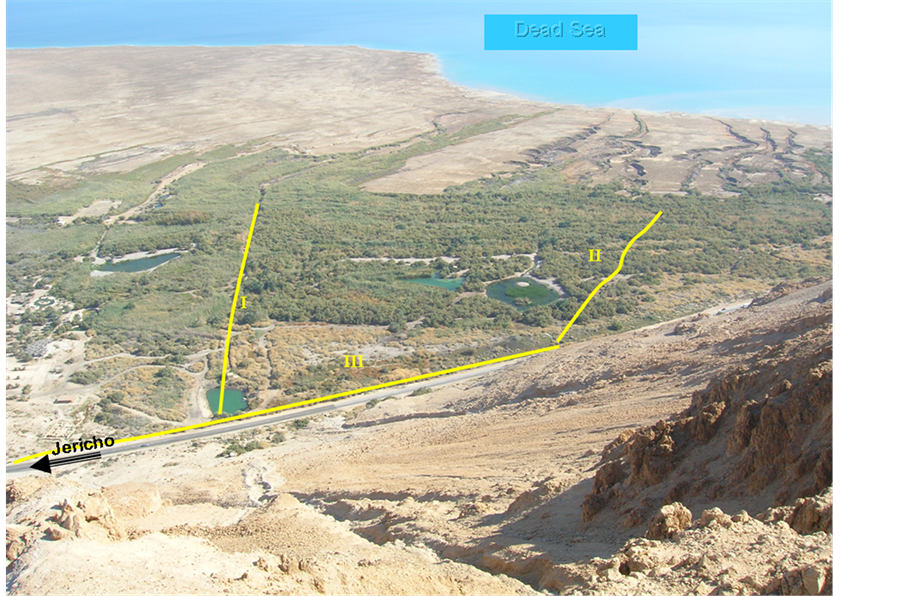
Figure 5. Location of the three profiles and the main topography of the area.
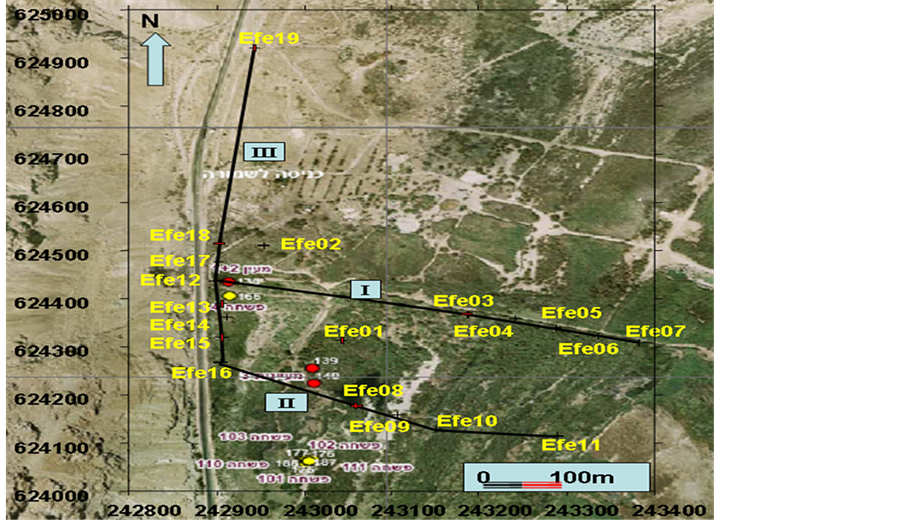
Figure 6. Satellite map with the localization of the VES-soundings on three profiles.

Figure 7. Vertical section along profile I.
large development of resistivity values ranges between 3 - 15 Ohm/m can be seen, suggesting the existence of fresh water over the whole investigated depth interval of 100 m. This domain corresponds to the area around Ein Feshcha main spring (1 + 2). This fresh water is being mixed with trapped saline waters leading to dilution of these saline pockets. Mixing tacks place at the vicinity of the spring at least at two points, this can be seen from the chemistry of the borehole log Feshcha-4. The chemical analysis and the lithology of borehole Feshcha-4 (Figure 8), shows that the salinity increases with increasing depth up to the depth of 37.5 m in which the maximum salinity values were EC: 26.5 mS/cm, Br: 166 mg/l and TDS: 16147 mg/l, afterwards the salinity decreases with increasing depth in which the values were lowered to EC: 11.4 mS/cm, Br: 57 mg/l and TDS: 6378 mg/l at the maximum depth of the borehole 49.5 m. This separation in mixing points could be attributed to the oily greenish clay layer found at the depth (32 m) with thickness around 4 m. This layer separates the upper layers from the lower layers. Several meters to the east two springs are exposed having the same chemical characteristics of the main spring (1 + 2) which could explain the source of water drainage from the lower layers. In the eastern part of the section, between the sounding points 5 - 7 at distance of 350 to 490 m along profile-I, starting from the depth of 60 m downward, high resistivity values up to 500 Ohm/m were measured, suggesting sedimentary rocks overlaid with sedimentary block from the late Pleistocene epoch. The borehole Feshcha-10 at Figure 8, presents the eastern lithology of profile-I, it shows that late Pleistocene-Holocene sediments are dominating the area up to the depth of 38 m and more. The sedimentary rocks are probably a block of limestone.
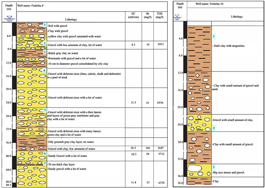
Figure 8. Lithological section presenting the lithological setting of Borehole Feshcha-4 and 10.
This block acts as a barrier in the advancing of saline water intrusion from the Dead Sea to the west not only but also it prevent the trapped water to retreat to the east, evidenced by low resistivity values, <1 Ohm/m. At sounding point 4, at distance of 300 to 350 m on profile-I, local low resistivity values suggest possible trapped saline/ brackish water, behind the assumed clay-limestone block.
3.1.2. Profile II
Profile-II extends also from the west (624263/242910) to the east (624114/243290), from the road toward the Dead Sea (Figure 6). This profile composed of 5 sounding points. The vertical section elaborated along this profile (Figure 9), shows that through the distribution of resistivity of the measured sounding points, at the depth interval 30 - 100 m at sounding point 11 resistivity values ranges between 0.35 - 0.8 Ohm/m at distance of 350 to 400 m on profile-II. According to Goldman guidelines, these low resistivity values << 1 Ohm/m are considered as brine waters and there source could be attributed to precursors of trapped Dead Sea saltwater or a retreat of Dead Sea saline waters. These low resistivity values extend toward the east through sounding point 10 until sounding point 9 in the west at distance of 200 m; this saline water is surrounded by a zone of brackish water. Near the surface, until the depth of 20 m the measured resistivity values suggest the existence of fresh water. In the western part of the section the values suggest the existence of fresh water, but over a smaller depth interval than of profile-I. At the western side of profile-II at the depth of 60 m and more a mass of late Pleistocene-Holocene sediments (clay and shales) is identified working like an aquiclude.
3.1.3. Profile III
Profile-III is located along the road, in the North-South direction (Figure 6). The coordination points of the beginning of this profile are, (624920/242944) while the end of the profile was at the coordinate of (624263/ 242910). This profile composed of 8 sounding points. On the vertical section along this profile (Figure 10), values of resistivity greater than 3 Ohm/m can be seen around the main spring suggesting the existence of fresh
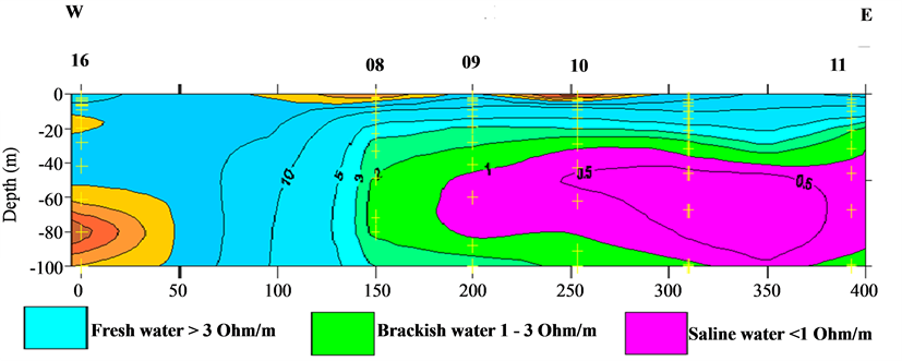
Figure 9. Vertical section along profile II.
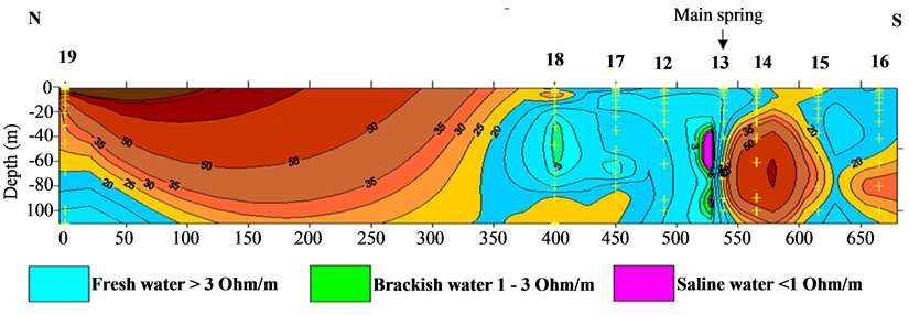
Figure 10. Vertical section along profile III.
water until a depth of 100 m. To the south of the main spring, on sounding points 14, 15 and 16, higher resistivity values were measured, suggesting the existence of sedimentary rocks overlaid with late Pleistocene-Holocene sediments (tills and clays) block, forming a barrier in the fresh groundwater flow along the North-South oriented main fault system. In the northern part of this section, at sounding point 19, the measured resistivity values suggest fresh water at greater depth, below 80 m and rising up in the southern direction toward the main spring. Between the sounding points 18 and 19, at distance of 25 to 325 m on profile-III. The soil was very dry may be due to the existence of tills filling the main fault system, the 34 resistivity measurements were not possible, therefore with the help of the available data and Zhody software the expected missing part were simulated. The results at this section suggests the existence of tills and limestone blocks, forming a barrier in the fresh groundwater flow along the North-South oriented main fault system, were exposed sedimentary rocks at the field site can be seen. At sounding point 18 low resistivity values were identified ranging between 1 - 3 Ohm/m indicating existence of localized brackish water zone at the depth of 30 up to 60 m. Very close to the main spring between sounding points 12 and 13 a mass of brackish water was identified with resistivity value ranging between 1 - 3 Ohm/m indicating existence of localized brackish water zone at the depth of 30 up to 100 m finding its way out in the main spring. Since these two localized zones are surrounded with fresh water then it can only be explained by a salt dissolution from the surrounding rocks (salt layer) and/or conduction of saline waters through associated fractures.
3.2. Electromagnetic Radiation (EMR)
Along Ein Feshcha natural reserve borders in a North-South direction along the main fault system a profile was constructed in order to localize the fractures and rupture zones in the underground. This profile was explored using the Electromagnetic Radiation (EMR) reflecting the orientations of active crustal stresses in the uppermost lithosphere. The beginning of the explored profile was at the coordinate (625000/242800) and the end of it was at the coordinate (624000/242800). Along this profile several scans East-West direction was carried out using the high-sensitive geophysical electromagnetic instrument (CERESKOP) depending on the NPEMFE-method. Through the NPEMFE-method a lot of fractures were identified, mainly along the main fault system of the Dead Sea Rift, but also two transversal faults perpendicular with the main fault, one of them crossing the main fault at the main spring (1 + 2). The first transversally fault can be seen in the field, extending in an East-West direction heading to the Dead Sea cliffs (Figure 11(a)) instrumentally this fault has been detected using the CERESKOP and it is plotted on Figure 12. The other one is located at Ras Feshcha farther to the South Figure 11(b). This fault needs to be studied in more details.
4. Discussion
The results obtained by the applied methods (VES and NPEMFE) and the field evidence gave more information about, the interfaces between fresh, brackish and saline waters. The lithological setting in the study area and localization of the faults and fractures exist in the study area. The combination of these two methods (VES and NPEMFE) with field observations gave more specific information which lead to more understanding of the mixing mechanisms. The VES measurements detect low resistivity (<1 Ohm/m) representing brines and the interface between them (brackish water) as well as the overlying fresher water bodies. In addition, high resistivity values >3 Ohm/m representing freshwater are also detected, underlying the brines. The presence of fresh water until a depth of 100 m in the area around the main spring (1 + 2) was shown also by the obtained distribution of the measured resistivities on profile-I. The only explanation for the fresh water source in Ein Feshcha is from Judea Mountains finding its way through the West-East transversal fault number 10. The occurrence of localized low resistivity water bodies (1 - 3 Ohm/m) in sounding points 2 and 12 on profile-I can be interpreted as a result of the existence of fracture number 1 and 2. These fractures may conduct waters with lower resistivities leading to mixing of the two water types. The source of the brackish water could be related to ascending brines across the fractures/salt dissolution. In the southern direction, immediately south of the main spring on profile-III, the resistivity values indicate the presence of a limestone block, displaced along a transversal fault, forming probably a barrier in the flow direction of the fresh water, obliging it to flow out and forming the main spring. Such a block was also signalized on profile-I, forming barrier in the advancing of the saline water from the Dead Sea toward the west. The occurrence of low resistivity water bodies until the investigated depth of 100 m, on profile-II, can be interpreted as trapped residual brines or salts, related to earlier Dead Sea base levels. These brines are mostly found in the East, closed to the Dead Sea base level and it has a horizontal development.
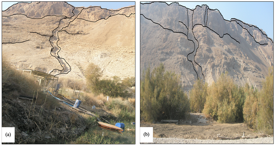
Figure 11. (a) East-West transversal fault crossing the main spring; (b) East-West transversal fault at Ras Feshcha.
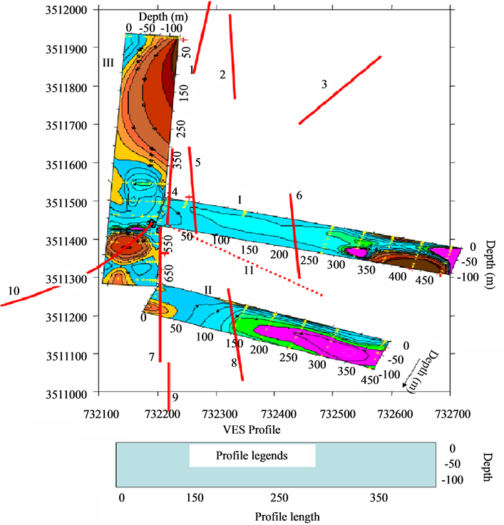
Figure 12. Fractures localized by combination of the stress variations using NPEMEF and VES method.
5. Conclusion
The outcome of the geophysical analyses method presented the existence of late Pleistocene sediments (tills and clays) block, forming a barrier in the fresh groundwater flow along the North-South oriented main fault system. The localized fractures and faults found working as barriers and/or conductors as well as the lithology barrier explain some of the water mixing mechanisms. The combination between all of what have been analyzed and noticed in the field, a schematic cross section can lead to fresh groundwater inflow from the aquifer to the spring area, the ascending brines along the fault forming a soft salt body in the shallower combined aquifer with an interface causing the overflow of the fresh water, a possible diaper shown here reasonably in larger depth as well as the discharge of the mixed brackish water in the Dead Sea sediment sequence. It can be concluded that the existence of brackish water above and below the saline domain and the variation of water quality even over short distances implies multiple hydrological aquifer systems and a fracture flow system controlling the Ein Feshcha springs. Understanding this concept will help to evaluate the impact of the groundwater extraction on the heads and flow patterns in the aquifer and to locate extraction wells.
Acknowledgements
We gratefully acknowledge the financial and logistic support provided by SMART project at KIT University which is funded by the German Federal Ministry of Education and Research (BMBF). Special regards to the staff of natural reserve Ein Feshcha for their support and understanding. Special thanks also go to the reviewers for their efforts for improving and finalizing the outcome manuscript.