Impact of the Human Activities on the Local Climate and Environment of the Suez City in Egypt ()
1. Introduction
Human activities during different civilizations have long been known to be categorized in either urbanization or cultivation. Urbanization has been and remains a major form of land use and land cover changes in human history [1] . The replacement of vegetation-cover by an urban highly impervious landscape, such as asphalts, concrete, and building rooftops prevents precipitation to penetrate soils. Urbanized areas usually exhibit high thermal conductivity and radiation heat budgets, characterized by increased atmospheric and surface temperatures when compared to the surrounding rural areas [2] . Urban materials, including construction materials, roofs, asphalt, concrete, metals, and roads absorb more heat from the sun. The subsequent energy release causes urban areas to be warmer than the surrounding non-urban areas, giving rise to the urban heat effect [3] . Therefore, the temperature difference between urban and rural areas contributes to the development of the Urban Heat Island (UHI). UHI quantitatively describes the increased temperature of either the urban surface, or the urban atmosphere compared to rural surroundings due to increased anthropogenic activities or the consequences of human activities. [4] emphasized a number of factors associated with UHI intensity, including building density [5] , industrial areas [6] , impervious surface fraction [7] , population concentration [8] , and road density [9] .
Remote sensing and geographic information system (GIS) techniques are powerful and effective tools widely applied in detecting the spatio-temporal dynamics of land use cover changes. [10] integrated remote sensing and GIS to study the urban thermal environment in Guangzhou. Normalized Difference Build-up Index (NDBI), and Normalized Difference Vegetation Index (NDVI) were used to qualitatively evaluate the relationship between LST and land use/land cover (LULC). The results indicated that most urban developed regions were located in high LST areas. LST is commonly increased with the density of urban development and bare land, but decreased with vegetation cover [10] . Remote sensing data provide a continuous and synchronized portrayal of urban surface temperature spatial patterns [11] . [12] applied remote sensing technology and spatial/multivariate statistics methods to examine the impacts of rapid urbanization on the urban thermal environment of Guangzhou, South China. The results indicated that urbanization in Guangzhou had a substantial effect on the regional thermal environment, with notable UHIs during 1990-2009. Mean temperatures were higher in urban areas than in the surrounding suburban/rural areas over the entire period. High temperature anomalies were closely associated with developed land, and heavily industrialized districts. Satellite-derived land surface temperatures (LSTs), obtained from satellite thermal infrared (TIR) imagery [13] , were employed to characterize UHI phenomenon [11] . The approach is positively related with (NDBI), and negatively with (NDVI).
The objectives of this study were to understand and analyze the local changes in thermal environment that occurred during a period of twenty-five years (1987-2012) in the northern parts of the Gulf of Suez. The region has been experiencing a rapid expansion in urban development, and vegetation cover over the last 25 years.
2. Data
2.1. Study Area
The Gulf of Suez basin is a northwest-elongated depression separating Sinai massif from the Eastern Desert—Red Sea hills. It is a topographic sink within the stable shelf of Egypt which is characterized by intensive block faulting and massive accumulation of sediments [14] . The sedimentary succession of the Gulf of Suez is generally thick one, ranges in age from Carboniferous to Recent and non-conformably overlying the basement rocks. The geologic and tectonic setting of the study area is inherited due to the regional tectonic framework of the Gulf of Suez and Red Sea rift.
The Suez Governorate is one of the fame Suez Canal Region’s urban governorates. It is located at the northern tip of the Gulf of Suez, where the Suez Canal leads forward into the north (Figure 1). The Suez Governorate occupies a total surface area of ~9000 km2. The area is bounded by Gabal Ataqa to the west and Suez Canal to the east.
The Suez Governorate infrastructure is supported by investments in wide network of internal and transportation roads, energy-generation stations, companies of drinking and sewage water, mature industrial zones, economic free-zone, international harbours, etc. Furthermore, the Suez Governorate supports many investment industries, including petroleum, foods, basic chemicals and chemical products, basic metallic, and engineering and electronic industries.
The Suez Governorate is divided into four administrative districts; The Suez City, Ataqa, Al-Ganayen, and Al-Arbaeen Districts. Ataqa District is a heavily industrial zone. Al-Ganayen District is a primarily zone of dense fruit cultivated lands. The Suez City is a growing industrial and commercial zone due to the presence of natural resources, including mineral and rock raw materials, ready-cultivated lands, growing fisheries, and scenery-touristic sites. Moreover, the Suez City centralizes most governmental commercial and economic bureaus and agencies. Al-Arbaeen District is a heavily populated urban area with many variable civilian activities.
2.2. Satellite Data
The satellite remote sensing provides a straightforward and consistent approach to determine the Urban Heat Island (UHI), expressing the thermal difference between urban and rural areas. In this study, the remote sensing images were used to recognize the relationship between the urban heat islands (UHI), and the land use changes during the time span extending from 1987 to 2012. Three sets of the remotely-sensed data were acquired; Landsat5 Thematic Mapper (TM) in 1987, and Enhanced Landsat Thematic Mapper Images Plus (ETM+) in 2000 and 2012 (Table 1). Using 3 remote sensing datasets are adequate during 1987-2012 to monitor significant LULC changes in the study site.
3. Methods and Image Processing
Two measuring methods are used to compute LST. These include 1) direct ground recorded LST, and 2) satellite-retrieved LST. The satellite-retrieved LST data have better advantages when compared to the ground measurements due to their high spatial resolution, extensive coverage area, and less time-consuming data retrieval.
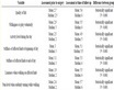
Table 1. Landsat TM and ETM+ satellite images data.
Generally, the remotely-sensed thermal imagery provides the potential to improve our understanding of urban surface energy budgets, and observe UHI effects. Thermal imagery generates a time-synchronized dense temperature data grid, and distinctive temperatures for individual buildings [10] . Thermal infrared information from satellites can be converted to brightness temperature using Planck’s law to measure surface temperatures [15] .
In the present study, the remote sensing image processing techniques were applied to classify land cover, and extract the UHIs in the North Gulf of Suez area during the period extending from 1987 to 2012.
3.1. Classification of Land Use and Land Cover
Image classification is used to automatically categorize all pixels in an image into land cover classes or themes. Unsupervised classification was performed separately on the three sets of remotely-sensed images (Table 1) using a histogram peak cluster technique to identify dense or frequently occurring pixelated areas [16] -[20] . In the unsupervised approach, spectrally separable classes are determined to form a supervised classification scheme. ENVI 4.8 was used to process satellite image classifications. [21] applied supervised maximum likelihood classification (MLC) to detect land cover classes. Once a sufficient number of the spectral subclasses were obtained for all information classes, a maximum likelihood classification was performed with the full set of refined spectral classes [19] . MLC is a statistically complex approach to classify images for change detection; however several studies reported that the methodology is most effective for supervised classification [22] [23] . Supervised classification was verified for each year using field investigation information collected from more than 25 ground checkpoints.
3.2. Calculation of Urban Heat Islands (UHIs)
Urban areas represent a complex mix of different land cover types and materials, including developed and vegetated areas, soil surfaces, and water bodies. Satellite sensors record earth’s surface image from the radiance value, which depends on land cover spectral characteristics. UHIs were retrieved from the study area using ENVI 4.8 and ERDAS Imagine 9.3 as follows.
3.2.1. Digital Number (DN) Values to Spectral Radiance Conversion
Landsat calibration equation [24] was used to convert the Landsat TM/ETM+ thermal infrared (TIR) band, low gain, (10.44 - 12.42 μm) digital number (DN) to spectral radiance in units (W∙m−2∙µm−1∙sr−1). All specific calibration coefficients, and related parameters, including sun elevation, gain and offset were extracted from a level 1 product header or ancillary data record.
3.2.2. Spectral Radiance to Effective At-Sensor Brightness Temperature Conversion
Spectral radiance was converted to the at-satellite brightness temperature (i.e. blackbody temperature) using Equation (1), [24] [25] . The K1 and K2 constant values for Landsat5 TM and Landsat7 ETM+ are shown in Table 2:
 (1)
(1)
where:
Ti: effective at-satellite brightness temperature in Kelvin;
K1: calibration constant 1 in W/(m2·sr·µm);
Table 2. TM thermal band calibration constant.
K2: calibration constant 2 in Kelvin;
Lλ: spectral radiance at the sensor’s aperture.
3.2.3. Effective At-Sensor Brightness Temperature to LST Conversion
LST can be extracted using Equation (2), [12] and [4] :
 (2)
(2)
where:
Ts: LST;
Ti: the effective at-satellite brightness temperature in Kelvin;
λ: wavelength of the emitted radiance (λ = 11.5 µm for Landsat band 6 data);
 = 1.438 × 10⁻² mk, where h is the Plank’s constant (6.626 × 10⁻³⁴ Js), c is the velocity of light (2.998
× 108 m/s), and is the Boltzmann constant (5.67 × 10⁻⁸ Wm−2∙k−4 = 1.38 × 10⁻²³ J/k);
ɛ: is the land surface spectral emissivity.
3.2.4. Normalizing LST
Top-of-atmosphere (TOA) radiances, which are measured by satellite thermal infrared sensors, are the combination of three energy types. TOA includes the emitted radiance from Earth’s surface, the upwelling radiance from the atmosphere, and the down welling radiance from the sky [26] . The differences between the TOA radiances, and land surface temperatures are influenced by atmospheric conditions. In the present study, despite the fact that the satellite images were selected during the same season, a normalization method was applied to avoid annual variation in atmospheric conditions [12] . This correction was performed by calculation of land surface spectral emissivity (ɛ), which varied significantly due to differences in soil and vegetation cover characteristics [27] . Land surface spectral emissivity values were estimated from NDVI values [28] , (Table 3).
NDVI was used to transform multispectral data into a single image band representing vegetation distribution [29] . NDVI values indicate the amount of green vegetation in a pixel. The standard algorithm was computed using ENVI 4.8 software, from the equation published in [30] . NDVI values range from −1 to +1; with higher values indicating more green vegetation. In highly vegetated areas, NDVI typically ranges from 0.1 to 0.6, whereas urban surface and water values are negative. The normalization method used equation (3) to extract UHIs from LSTs (Table 4).
 (3)
(3)
where:
Ui: UHI;
Ts: LST;
Tmin and Tmax: minimum and maximum LST retrieved from all data, excluding extremes.
4. Results and Discussion
Unsupervised/supervised image classification procedures for Landsat Thematic Mapper data obtained during 1987-2012 were employed to generate detailed land use categories. Unsupervised classification classes were
Table 3. NDVI values and its corresponding values of land surface spectral emissivity.
Table 4. Urban Heat Island (UHI) range and its classification.
very similar to those produced in the supervised classification scheme.
Maximum likelihood supervised classification was applied to Landsat images acquired in 1987, 2000, and 2012 to assess land cover classes. Six land use categories were identified (Figure 2), including:
1) Surface water;
2) Quaternary playa deposits;
3) Fluviatile and lacustrine deposits;
4) Nile deposits and cultivated area;
5) Urbanized land; and 6) Miocene (gypsum and carbonate deposits).
Each class was checked and verified in the field using a Garmin 38 GPS unit, where more than 25 ground data sites were visited and examined. Results have shown that the urbanized areas have been increased from 49 km2 in 1987 to 57 km2 in 2012, whereas the areas of vegetation-cover have been expanded from 3.0 km2 in 1987 to 26 km2 in 2012.
[31] stated that with population growth, a consequent rise in urbanization takes place. This implies that the increasing building-rate in cities resulted in a noticeable reduction in green areas coupled with marked increase in impervious surfaces. [32] demonstrated that the excessive heat energy absorbed by an urban construction is large enough to raise the average temperature of urban areas by several degrees relative to surrounding nonurban areas.
In the present study, it was found that remote sensing technology was of adequate usage to monitor the impacts of urban growth and vegetation expansion on thermal environment in the North Gulf of Suez over the last 25 years. The thermal bands were processed to obtain radiant surface temperatures to investigate spatial and temporal effects of UHI associated with increasing urbanization and vegetation cover. Results have shown that the urban temperatures decreased from 1987 to 2012 (Figure 3). This can be explained in terms of the increasing role of the agricultural activities done over the last 25 years. During this period, many cultivated areas have replaced barren poor land. The UHI mitigation strategies, such as urban vegetation, play a remarkable role in cooling the urban environment. [33] have evidenced the significant role of vegetation cover in cooling effect, where the plants absorb much of the incoming solar radiation, and dissipate energy via transpiration rather than energy conversion to heat.
Efforts conducted to increase cultivated lands in urban environments help in reduction of surface temperature and cooling of the surrounding air.
Based upon the above findings, it is herein confirmed that the urban development and vegetation expansion are the major land cover changes that significantly impacted the thermal environment in the northern part of the Gulf of Suez during the last 25 years.
5. Conclusions
1) Three sets of Landsat Thematic Mapper images were used to classify land cover, and calculate UHIs in the northern part of the Gulf of Suez during 1987-2012.
2) Six land use classes were identified, including: surface water, quaternary playa deposits, fluviatile and lacustrine deposits, Nile deposits and cultivated area, urbanized land, and Miocene (gypsum and carbonate deposits).
3) Urbanized areas have been increased from 49 km2 in 1987 to 57 km2 in 2012, whereas the areas of vegetation-cover have been expanded from 3 km2 in 1987 to 26 km2 in 2012. Many barren lands are largely replaced by cultivated and vegetated ones.
4) Accordingly, the urban temperatures were directly decreased from 1987 (wide areas with very high and high temperatures) to 2012 (limited areas with moderate and low temperatures). Generally, moderate and low temperatures were progressively increased from 1987 to 2012.
5) The results of this study confirmed that urban development and vegetation expansion were the major land cover changes that significantly impacted the northern part of the Gulf of Suez thermal environment. The study has proved that despite the increased urban and industrial activities at the northern part of the Gulf of Suez, the thermal environment has experienced a decrease in values due to the expansion of cultivated/agricultural activities.