In this study, an algorithm to transform LANDSAT 8 images of Lake Guiers into chlorophyll-a concentration maps was developed. The objective was to see the feasibility of this method as a mapping tool for monitoring the trophic state of the Lake. The available data are 15 in-situ measurements of the CHL-a content of Lake Guiers’ water using a Micro FLU device and images of the lake acquired in 2013 and 2016 by the LANSAT 8 OLI sensor. A series of correlation tests (simple linear functions, multi-variables, or containing two- order terms) were performed between the spectral sensor signal of June 19, 2016 LANSAT 8 image (“corrected” and converted into reflectance) and the CHL-a content of Lake waters measured on the same day of the satellite record. This was, to find the best regression equation that can be inferred to develop an algorithm to transform LANDSAT 8 image into CHL-a concentration maps. The best equation obtained by correlating the ground truths and the reflectance ratios of the visible and near infrared bands (B2, B3, B4 and B5), is as follows:
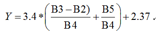
where B2 = Blue band, B3 = Green band, B4 = Red band, B5 = NIR band. The obtained
R2 is 0.703 (e.g., a correlation coefficient
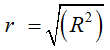
of 0.84), revealed that the measured concentrations are well reproduced by the regression model. Applying this model to the 2013 and 2016 image data revealed the monthly variations of the lake CHL-a contents and their seasonal evolution and interannual variations. The obtained results are quite consistent with those from similar studies and provide valuable information regarding Lake Guiers’ vulnerability to algal development. The calculation and analysis of the variability of the CHL-a contents over the study period made it possible to evaluate the trophic state of the Lake, which shows a general tendency for eutrophication process, leading to a progressive degradation of the quality of the water resource.