Comparison of Indoor Localization Systems Based on Wireless Communications ()
1. Introduction
The modern world is centered on communication and speed. We want to be informed as quickly and reliably as possible about our health, the state of our environment, our current safety. Wireless Sensor Networks (WSNs) are a type of network that has been developed as a response to this need for control. Their nodes aim to become part of our environment and, using embedded sensors, help us monitor the status of relevant parameters.
As the needs evolved, the attention has turned to mobile sensors, introducing a new constraint: the collected data must be mapped to a specific location in order to ensure a correct interpretation of the values. Let’s consider a mobile temperature sensor. When a measurement exceeds a set threshold, the system’s reaction will depend on the current location of the node. Each predefined zone will be associated to an acceptable temperature range according to the usual activities taking place in this space. For example, during winter, detecting a temperature below 4˚C in a bedroom hints a possible failure of the heater. On the other hand, the same value in a garage is perfectly normal. For the system to choose between alerting the system manager and ignoring the new value, the sensor’s location must be available.
Position aware network nodes can also help in routing [1]. The benefits of localization being shown, the question is: How do we determine it?
We are not the first group to find this topic interesting. Therefore, we plan on beginning with a description of the tools and methods generally used to solve the localization problem. We will focus on indoor solutions and ones that require minimum participation from the target. We will then introduce propositions that represent the current trends in location determination before identifying possible research areas and concluding this article.
2. Classical Localization Algorithms
When trying to localize an item, the first step is to define references. In this document, our references will be a subset of the network nodes. They will be aware of their location and will be referred to as “beacons”. Another term frequently used for this purpose in the literature is “anchor”.
The network’s deployment area can be either indoor or outdoor. In the first case, the radio signal mainly suffers from attenuation and reflections. In the latter, setting up links on high distances and maintaining them becomes a great challenge.
Once the references have been established, relative location determination becomes possible. According to the implementation choices, this operation can be executed either by the mobile node or by a central node with greater processing power. When the mobile node is responsible for calculating its own position, an efficient algorithm must be used. The other solution requires the installation of at least one localization server who will process requests from all nodes in the network.
The following subsections will introduce mathematical tools for positioning using 3 anchors as a reference.
2.1. Trilateration
This method requires the knowledge of the distance between the mobile and each beacon.
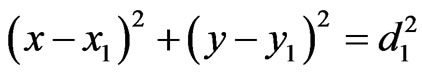
Let the anchors be B1, B2 and B3. M is the node we want to localize. The positions (xi, yi) of the beacons as well as the distances di are known. The relationship between M, B1 and B2 can be written as:
 (1)
(1)
 (2)
(2)
M is therefore located at the intersection of circles C1(B1,d1) and C2(B2, d2). A third circle generated using the information of B3 enables us to choose the correct position between the two solutions of the general case of two circles intersecting (Figure 1).
2.2. Triangulation
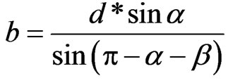
In order to apply this method, the mobile must be aware of the distance between two beacons and the angles α and β as shown in Figure 2. The law of sines yields:
 (3)
(3)
 (4)
(4)
Once the characteristics of the triangle are known, the coordinates of the third summit can be calculated. As stated while describing trilateration, the third beacon or an additional hypothesis will allow identification of the correct solution.
2.3. Fingerprinting
This method is a pattern-recognition technique. It comprises to steps: in the first step or learning stage, some characteristics of the environment are measured at different locations and the data is stored along with a spatial
reference information. This step is also qualified as offline phase since it is usually performed before the activation of the localization service provided by the network.
The second step or online phase begins when the network is up and a mobile wants to determine its position. The same parameters are measured and the results are compared to the stored values.
The inherent modularity of fingerprinting enables researchers to work specifically on one phase or the other: hence the various propositions for selecting a position by comparing online and offline data.
According to the behavior of the measured characteristic through time, this method can be very interesting. Unfortunately, its cost in terms of setup time and data volume is high. Furthermore, any change in the configuration such as moving a beacon or modifying the environment, will imply creating a new database. In the case of a mobile WSN, the need for partial to complete updates will happen frequently.
2.4. Multilateration
Multilateration requires time information rather than distance. The time difference of arrival of a signal (TDOA) is used to determine position.
Figure 3 presents the case with the mobile being able to reach 4 beacons which are synchronized. The mobile node broadcasts a frame. Every beacon receiving the frame stores the local time of reception then calculates the difference between this time tag and the one provided by a set reference beacon. The collected time differences