1. Introduction
Volcanic activities are globally important phenomena affecting both environment and human life. Satellite and airborne remote sensing methodologies have proven to be extremely valuable for examining and evaluating the effects of eruptions over large scale. High temporal resolution systems like MODIS (Moderate Resolution Imaging Spectroradiometer) have been used for mapping the evolution in time of the volcanic plume [1-3]. High spatial resolution systems such as ASTER (Advanced Spaceborne Thermal Emission and Reflection Radiometer) have been extensively used for global scale mapping of volcanoes [4]. During eruptive crisis, on demand, airborne acquisition has provided details on the phenomena allowing the description of the morphology and evolution of lava flow fields [5,6] and thermal anomalies characterisation [7].
In studies of precursory signals, major indicators of upcoming eruptions are: volcanic tremor [8,9], ground deformation [10], thermal anomalies and gas emissions [11]. Seismic tremor and volcanic gas emissions, for example, are related to upcoming eruptive activity but the mechanisms are not yet completely understood and more data as well as new parameters are needed. Surface temperature anomalies have been remotely investigated, but their use has been limited so far by the poor spatialtemporal resolution of satellite systems or by the expensive costs of dedicated airborne measurements.
Furthermore, these volcanic phenomena rarely maintain a stable level of activity in time and this is the reason why reliable forecasts should be made by well-organized volcano observatories which operate at a local scale. Italy has many active volcanoes that are continuously monitored by the networks of instruments held by the Istituto Nazionale di Geofisica e Vulcanologia (INGV), which operates at both ground and airborne scale.
INGV has been using hand-held thermal cameras since 2001 during both ground-based and helicopter-borne surveys for the surveillance and monitoring of Mt. Etna, Stromboli, Vulcano, Campi Flegrei and Vesuvius activity [3,12-17]. Indeed air-borne surveys provide information crucial to get an overall view of the eruptive scenarios, especially in the case of wide active areas such as lava flow fields, crater fumaroles and hydrothermal zones [18]. These surveys provide information to be used for thermal imaging-derived parameters such as heat budgets and effusion rates [13,17,19]. However, one of the main drawbacks in the use of helicopters is their cost and the risk for operators and pilots, especially during volcanic paroxysmal phases.
In order to find a compromise between the advantages and disadvantages of air surveys, in 2004 INGV started to investigate the possibility to use remotely, Piloted Air System (RPAS) for volcanic environment applications. The first test was carried out by a joint collaboration between INGV and Università di Bologna seven years ago at Stromboli volcano [20,21]. From that period of time, the activity has evolved with the aim of equipping systems with sophisticated instrumentation which could support the scientists work. Great efforts have been made in order to study how to improve technical systems and instrumentations for risk management including volcanology. Telemetry and, in real time, acquisition system have been developed and tested at laboratory-field scale [22]. In this paper we describe a field experiment performed in June 2012 by flying a thermal camera-equiped hexacopter over the Salinelle mud volcano (Sicily, Italy). Firstly, we describe the main platform and the characteristics of the sensor used for the experiment; secondly we describe the geological setting of the investigated area. Finally, we discuss the results, including the cross comparison between in-flight and in-situ independent thermal mapping. The relevant result is that we not only realized qualitative hot-cold map of the mud volcano, but also associated the temperature values.
2. Methods
2.1. The Multirotor System
The unmanned system used for our purposes is a rotorcraft with six rotors (hexacopter). This kind of aircraft uses fixed-pitch blade and brushless motor rigidly fixed to the structure. Since the speed of each rotor can be independently regulated, the control of model, in terms of attitude, position ad movement, is obtained by modifying the trust and torque produced by each rotors; this effect is obtained simply by modifying the relative speed of each rotor.
Since this kind of vehicles are generally unstable, a Flight Controller Board (FCB) which include GPS receiver, air pressure sensor, Inertial Measurement Unit, is installed. The FCB allows to use the radio-controlled system.
The multicopter in hexacopter configuration, used in our work, is the Easy fly A2500 (www.salengeneering.it); this model has been improved in rigidity and weight by using carbon fiber parts instead of aluminum. It has a diameter of 100 cm and a height, from ground to the center plate, of 30 cm. It is powered by two battery packs (5000 + 5000 mAh) allowing an autonomous flight of about 15 min - 20 min according to the batteries and payload (Figure 1). In our configuration, the payload weight was 1.7 Kg and the estimated maximum ceiling of 200 m (70 m by ENAC Italian regulation). Due to limitation in national regulation in matter of RPAS, the system flew in line of sight and by radio control. For the experiment, the hexacopter was equipped with a thermal EYE 3600 AS (TE 3600 AS) designed for Original Equipment Manufacturers (OEMs). The TE 3600 AS is microbolometer technology based consisting of 30 µm pitch detectors, which make possible a lightweight of 67 g. The spectral response is in the range 7 - 14 µm with a thermal sensitivity less than 50 mK and a saturation temperature of 600˚C. The camera has a frame rate of 25 hertz real time and generates a PAL video output. The camera is characterized by an automatic contrast that is decreased and increased according the scene. For each thermogram acquired by the camera a calibrated temperature value is provided in correspondence of the central spot while a color scale bar on the right side of the image shows the minimum and maximum temperature range expressed in decimal Celsius degrees. To integrate the camera with the system an acquisition system has been developed based on the philosophy to use commercial components. The result is a cubic embedded solution (12 cm × 11 cm × 8 cm, and weight of 600 gr) composed of four PC-104 compliant stackable modules: Power supply, Frame grabber, PC and Wi-Fi module [22]. In order to fix both

Figure 1. Hexacopter UAV system: the locations of battery pack (BP), thermal camera (TC) and acquisition system (AS) are shown.
camera and acquisition system on the hexacopter, MDV designed and realized a specific set-up. Aluminum was preferred for its low weight. A standard female USB connector allows the GUI communication and A DB9 connector reports all camera pins, including analogue video output was properly configured. The final flight configuration including payload and acquisition system is shown in Figure 1.
2.2. Geological Setting of the Salinelle Mud Volcano
The Salinelle mud volcanoes occur in three sites located on the lower SW flank of Mt. Etna volcano (Italy) Figure 2. The geology of the area includes: 1) volcanic products erupted from Mt. Etna (Mongibello cycle, dated 35 ka to Present, [23] that outcrop in the northern and northeastern parts of the area; 2) terraced alluvial deposits (mostly conglomerates and clays) dated to 125 to 40 ka [23]; 3) small outcrops of alkali lavas belonging to the Timpe phase [24] that are present in the central and north-western parts of the area, and are best represented by the volcanic neck of Paternò [25], whose age was calculated at 168 ka by [26] or at 210 ka by Condomines [27]; 4) sub-alkalic lavas dated to 580 to 250 ka [23]; 5) Early-Middle Pleistocene foredeep deposits (1200 - 600 ka) mostly made of marly clays [23] that fill the Catania basin and outcrop in the eastern part of the area; 6) units of the Apenninic-Maghrebian collision belt, mostly composed of quartz-arenites and clays [28,23]. For the purposes of this study, the best site for the test was that of the Salinelle of Paternò Stadium, located at the NW boundary of the city of Paternò very close to the local football stadium. In this site fluid emissions occur on alkali lavas close to the Paternò volcanic neck (Figure 2(c)). The fluids escaping from these manifestations are composed of a gas phase and hypersaline waters that often pond in pools that range in size from centimeters to
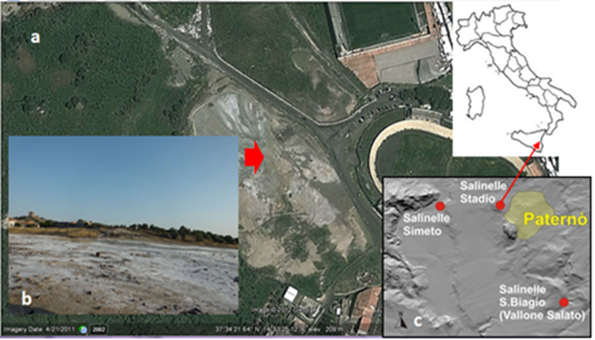
Figure 2. (a) Visible image as acquired by GeoEYE (Google Earth, 37˚21'64"N 14˚53'25.12"). Inset (b) shows the area selected for take-off and landing of the hexacopter UAV system; inset (c) shows the location of the three mud volcanoes named “Le Salinelle”.
meters in diameter. The mud and water mixtures are highly variable, and in some cases mud is the only fluid erupted with gas, and it builds cones up to a few meters high and with a base diameter up to about ten meters. Emitted waters have rather uniform and constant chemical compositions and physical-chemical characteristics; their pH is about 6, the electrical conductivity of about 88 mS/cm, the chemical abundance of major species in solution (on equivalent basis) is Na >> Ca > Mg > K and Cl− >>  > SO4 = [29-31]. During the summer intense evaporation produces large salt crusts around the emission vents, hence the name of such manifestations (from the Italian word “sale”, which means salt). Most of the pools and mud vents are ephemeral and show strong temporal variations in the gas flow. Water outlet temperatures are normally between 10˚C and 20˚C, but occasionally increase to 40˚C - 50˚C [31,32]. Such anomalous temperature values are always accompanied by increases in the gas efflux.
Many paroxysms occurred in the degassing activity of the Salinelle in the past. [31,32] reports of strong eruptive activities in early 1866 and late 1878, with fountains of muddy water up to 3 m high and water temperature up to 46˚C, that the author relates to local seismic events that occurred some days/weeks prior to the gas eruptions. During the past 15 years similar increases in degassing activity have also been recorded at the Salinelle [S. Giammanco, unpublished data]. These events normally lasted from two to four months. The main component of the gas escaping from the studied sites is CO2. In all of the sites, air components are very low or are absent. Methane is normally the second most abundant gas species, although with highly variable amounts among the sites. Other minor species emitted include N2, He, H2, CO, H2S, Rn and other light hydrocarbons [29,30].
Normally, gases from the Salinelle are sampled by using inverted funnels placed on the ground over the smallest vents or on the water/mud surface right over gas bubbling areas in the case of larger vents, where accessible. Funnels are connected to gas flasks for gas collection. Field measurements of water/mud temperature are normally carried out using thermocouples when vents are directly accessible or using laser devices from a distance. Since 2006, water/mud temperature measurements were carried out only using a non-contact laser-guided IR temperature meter (Fluke Corporation, WA, US, mod. Fluke 68), with accuracy of ±1% for targets above 23˚C and of ±2˚C for targets between −18˚C and 23˚C. However, due to the large variability both in the position of gas and water vents and in the gas flux, the use of devices able to easily and quickly monitor the whole degassing area is fundamental.
2.3. Experimental Setup and Results
The experimentation was carried out on 26 June 1012. The hexacopter was pre-assembled while payload and system were configured in situ. The weather conditions were favorable though the day: air was extremely hot even in the afternoon (up to 32.2˚C, as reported by meteo Sicilia, http://meteosicilia.it). The flights were planned during the early evening in order to reduce the effects of heat and reflection from the ground [33]. The autonomy of the system was about 15 min, so we could carry out only two flights to cover two different areas of the Salinelle. Although the site has a good accessibility, it is located in a urban area, hence both take-off and landing had to be performed at the edge of the mud volcano area, that is a zone characterized by unstable muddy surface (Figure 3). In order to verify the suitability of the method in extreme environment conditions, we tested the stability of the acquisition and of the transmission systems. Then we investigated the possibility to obtain both qualitative (mapping of the active degassing areas) and quantitative (temperature distribution) thermal information. In order to obtain a quantitative mapping of the Salinelle volcano, a Forward Looking InfraRed (FLIR) thermal camera was used. The FLIR camera was a A310 model consisting of a 320 × 240 microbolometer detector array operating in the 8 - 14 µm waveband, with dynamic range of 0˚C to 350˚C and accuracy of ±2% of reading (see http://www.flir.com for more details).
Six thermogram from the video recorded by thermal EYE 3600 in correspondence of six areas in the FLIR image were processed [34] to choose the area for comparison Figure 4.
Similarly to the ground-based temperature measurements of one of the cold pools yielding mean values of about 34.7˚C (Figure 4(b)), apparent temperatures of the same pool measured in-flight gave values of about 34˚C as well (Figure 5(c)). We observed that the good agreement was reached despite the different viewing geometry of the two cameras (i.e. horizontal in the case of the FLIR camera, vertical in the case of the drone-borne camera).
For emissivity we used a value of 0.95 derived by an emissivity spectrum measured by µFTIR one day after (Figure 5) and in agreement with same values for soil saturated with water [35].
The second flight was performed in the area which is usually mapped by the field laser system. This site is characterized by a quite large area affected by water and CO2 emissions. We meant to compare the temperature measured by the in-flight system with the measurement realized in an independent method. Figure 6 shows the area investigated during the second hexacopter flight and the thermal frame acquired in correspondence of the site regularly mapped. The temperature detected at the center of the TC3600 image is 22˚C.
Figure 7 shows the time series of the Salinelle highest