Exploratory and Descriptive Study of the Kimberlite Massif of Boya-02 at Eastern Kasai in the Democratic Republic of Congo ()
1. Introduction
Diamond kimberlites are one of the world’s leading sources of natural diamonds. Understanding its edifices is very important for diamond exploration since a kimberlite is not necessarily diamond-bearing, in fact less than 1% would be (Jébrak & Marcoux, 2008) . However, these deposits are interesting because great profitability once in operation. It is therefore important to know the main characteristics of a diamondiferous kimberlite deposit, such as grade and tonnage, mineralogy, host rock, sources, formation ages, shape, structural domain and of course genetic model and exploratory techniques (Mutombo et al., 2023) .
The African continent, which is largely cratonized, is very rich in kimberlite intrusions and other alkaline intrusions (carbonatites, nepheline syenites), concentrated mainly in the southern part of the continent and in central Africa (Figure 1). In Central Africa, kimberlite intrusions (diamond-bearing and non-diamond-bearing intrusions) are found in Gabon, Tanzania and Kenya, and mainly in Angola and the Democratic Republic of Congo (DRC). Most of the kimberlite provinces of Central Africa are deposited in the Archean Craton of Congo-Kasai.
![]()
Figure 1. Map of Africa on a background of the speed structure of seismic waves (Vs) (at 100 - 175 km depth) whose scale represents the difference in speed compared to a predefined model for the Earth.
This map highlights the cratonic blocks. It represents the distribution of kimberlitic intrusions (white squares) and other alkaline intrusions (carbonatites: green stars; nepheline syenites: pink circles), as well as Meso-Cenozoic rifts (blue polygons) and volcanoes (asterisks) (Begg et al., 2009) .
Two kimberlite provinces have long been known in the DRC. These are the diamondiferous kimberlites of Mbuji-Mayi, in the Kasaï-Oriental province, and the non-diamondiferous kimberlites of the Kundelungu plateau, in the Katanga province, in the southeast of the DRC.
The Mbuji-Mayi and Kundelungu kimberlites were respectively emplaced in the Archean Congo-Kasaï craton and the Neoproterozoic Katanguian orogenic belt which borders it to the east. A third kimberlite province was recently identified 200 km northwest of Mbuji-Mayi, in the Luebo region (Kasaï-Occidental), on the Congo-Kasaï craton (Waele et al., 2008) . Its presence had long been suspected because diamonds and minerals indicative of the presence of kimberlites (i.e. ilmenites-garnets-zircons) have been widely observed (Batumike et al., 2009) .
The Boya-02 kimberlite under study is part of the kimberlites of the kimberlite province of Mbujimayi in the province of Kasai Oriental. This occurrence was not known from the scientific and geological literature of the region because it was buried deeply. It was during the 2007 geophysical campaign carried out by De Beers DRC Exploration on February 13, 2007 that it was highlighted by an aeromagnetic anomaly 193/172/X298 (Report, 2009) .
From this anomaly, several exploratory and descriptive research was launched by the said company, universities and research centers whose aim was to determine the nature, describe, classify and define this boya-02 kimberlite while modeling its context of placement.
However, on the basis of the various research reports, in particular the report of the results of the geophysical campaign, the drilling report, the petrographic, mineralogical and geochemical analysis of this kimberlite, we were able to explore, define, describe and classify this kimberlite occurrence as we present it in this work. For this purpose, this occurrence is a kimberlite that has been classified as a highly diluted, rich re-sedimented volcaniclastic kimberlite (KVR) heavily diluted, rich. The Boya-02 kimberlite was modeled using ground magnetism data and comprised of 2 variable amplitude components with modeled dimensions of the order of 0.32 Ha and 0.2 Ha at depths of 32m and 14m for the western and eastern deposits respectively.
2. Study Area
The Boya-02 kimberlite is identified between the parallels E: 23˚15' and E: 23˚30 and the meridians S: 06˚00' and S: 06˚15', more precisely between 600 to 650 m altitude, at 6˚17' South latitude and 23˚17' East longitude; approximately 50 km southwest of Mbuji-Mayi in the territory of Miabi in the Province of Kasaï-Oriental in the DRC. The nearest major town is Mbuji-Mayi. and access to the site is relatively easy. Roads in this area are accessible (by 4 × 4 vehicle) during rainy and dry seasons (Figure 2). We have a two-season climate which applies throughout Kasai. The soil is more lateritic and the vegetation is characterized by a mixture of savannahs, shrub savannahs of various types, gallery forests and scraps of protophytic forest. This area of a morphological view bridge is a peneplain.
This site is located in the northern part of the central core of the Kasaï block of the Congo craton. Figure 3 summarizes the geological information available on the Boya-02 kimberlite area and Diagram 1 shows a regional profile with a geological model of its establishment. The Dibaya Basement Complex is characterized by banded gneisses and migmatites and enormous biotite granites. The regressive metamorphism of migmatites to the degree of amphibolite facies had affected the Dibaya complex at approximately 2.7 Ga. In the project area, the outcrop is characterized by a Proterozoic supracrustal sequence with progressive gradient which irregularly covers the Archean basement comprising the Dibaya granites to the west and south of the town of Mbuji-Mayi (Demaiffe et al., 1991) .
![]()
Figure 2. Location map of the Boya-02 site.
![]()
Figure 3. Regional geology of the Boya-02 site.
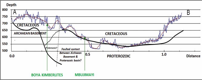
Diagram 1. Regional profile of the Boya02 Kimberlite with a geological model of its establishment (Technical Report from De Beers Group Exploration, January 2009).
The supracrustal sequence is characterized by basal sandstones with intercalations of conglomerates and gravels, argillite, siliceous dolomites and cherts, dolomites and dolomite shales, gray and pink quartz feldspathic sandstones, gray dolomites with stromatolites, flint dolomites, conglomerates, dolomites, argillite and flint dolomites (Mvuemba, 1980) .
As we listed above, regarding this Boya 02 kimberlite, it was simply identified on February 13, 2007 from the aeromagnetic anomaly 193/172/X298 from a single probe AM survey in 1997 and a gravity survey in 2006.
Until the current state of knowledge, this kimberlite had not been studied in depth to confirm its existence based on said anomaly and thus proceed to its petrographic and petrological description to better understand its nature as a kimberlite.
Motivation for which, in this article, it was a question of carrying out a compilation and superposition of data from research and exploration work undertaken to highlight kimberlites more or less 50 km southwest of the city of Mbujimayi in the Miabi territory so that from the geophysical, geochemical, petrographic and drilling data carried out we can describe the geological nature of the Boya-02 kimberlite.
3. Methodology
The operations carried out, in terms of methods and materials undertaken as part of this research work, aim to discover the kimberlites at the Boya-02 site and to gather first-degree information, including an evaluation in 2D dimension from geophysics, drilling, petrographic analysis of rock samples and estimation of diamond interest and potential from the mineral chemistry of garnets and trace element analysis. “The various inputs and related outputs are developed below.”
These studies consisted of research and investigations carried out in the field with the aim of allowing us a good reading, discussion and interpretation.
3.1. The Geophysical Method
Available and relevant geophysical methods were used to research and/or determine the particular Boya-02 kimberlite massif, by highlighting anomalous structures (different from the surrounding environment). Within the strategic framework, several geophysical survey methods could be used, namely:
• An airborne radiometric survey: this airborne radiometric survey makes it possible to quickly obtain, by aerial means, a geochemical map of the soil. Like other soil geochemistry techniques, this method provides access to the composition of surface materials;
• A Spectrum survey;
• A magnetic lift on the ground; it is a basic geophysical prospecting tool. this method makes it possible to measure the magnetic susceptibility contrasts of rock formations and thus to trace the geological image of a sector;
• A Gravimetric survey: the gravity survey provides diagnostic information on variations in subsoil density and makes it possible to identify the presence of a deficit or excess of mass in relation to the regional gradient;
• A Ground Electromagnetic Survey: (EM) is mainly used to map the variations in electrical conductivity and/or electrical resistivity of the Quaternary substrate and the underlying geological formations.
3.2. The Geological Method
Study methods and geological knowledge apply in many societal, economic and industrial fields, such as the exploitation of raw materials, civil engineering, water resources management, environmental management or prevention natural hazards. Regarding this work, we were able to use:
• Drilling: Set of techniques allowing a well to be dug to sometimes very high depths.
• Petrography: Petrography is the science whose object is the description of rocks, the analysis of their structural, mineralogical and chemical characters, and the relationships of these rocks with their geological environment.
3.3. The Geochemical Method
Geochemical prospecting methods are based on knowledge of the distribution of minor elements in rocks, soils, water and plants, with the aim of determining regions where this distribution is abnormal for one or more elements.
3.4. The Geochronological Method
This method consists of using the different methods of relative and absolute geochronology based on the exploitation of documents and data.
These methods were used during the prospecting campaign carried out by the company Minière de Bakwanga in partnership with the company De Beers RDC Holdings sprl—De Beers DRC Exploration sprl, the final report of which (updated in January 2020) was published available for scientific work.
4. Results
The results of the discovery work on the Boya-02 kimberlite massif are as follows.
4.1. On the Geophysical Level
Geophysical work to follow up the discovery stage was carried out in the area between 2006 and 2008 (Table 1).
1) Aeromagnetism on Boya:
An Xcalibur aerial radiometric survey carried out at the end of 2006 at a spacing of 150 m and a height of 40 m identified the anomaly 193/172/x263 (Figure 4).
2) Spectrum in the Boya Region:
A Spectrum survey called Tshiniama was carried out SW of Mbuji-Mayi covering 179.6 km2 with line spacing of 150 m and stations of 13 m for a total of 1394 line km (Figure 5).
![]()
Table 1. Geophysical details of the discovery stage of the Kimberlite Massif.
![]()
Figure 4. X calibur aerial survey in 2006 in the region of the Boya-02 site.
3) Ground Magnetism on Boya-02
A ground magnetic survey was carried out in 2008 covering 1.07 km2 with line distances of 50 m and 10 m between stations for a total of 19.2 line km (Figure 6).
4) Gravimetry on Boya-02 (193/172/S260)
A gravity survey was carried out in 2008 covering an area of 1.35 km2 with distances between lines of 50 m and 10 m between stations for a total of 22 line km (Figure 7).
![]()
Figure 6. Ground magnetic survey on Boya-02.
![]()
Figure 7. Terrestrial gravity survey on Boya-02.
5) Ground Electromagnetism on Boya-02 (193/172/S248)
A ground electromagnetic survey was carried out in 2007 covering 0.38 Km2 with line distances of 100 m and 20 m between stations for a total of 7.48 line Km (Figure 8).
4.2. On the Geological, Geochemical and Geochronological Plan
1) Drilling
A total of 771 m of drilling was completed with six discovery holes in the Boya-02 kimberlite (Table 2) to collect sufficient samples for garnet collection.
2) Petrography
Petrographically, the Boya-01 kimberlite is described as a fine-to-medium-grained re-sedimented volcaniclastic kimberlite (RVK), rich in quartz and poor in juvenile substances. The estimate of economic interest shows a low diamond potential due to the low juvenile content and high dilution (Figure 9).
![]()
Figure 8. Ground electromagnetic survey on Boya-02.
![]()
Table 2. Drilling information from the Boya-02 Kimberlitic Massif discovery stage.
![]()
Figure 9. Highly altered olivine macrocrysts in a quartz-rich matrix, the Boya-02 Kimberlite. PPL, 5X.
3) Mineral Chemistry
Garnet chemistry shows an average interest in raising with regard to the maximum Pmin value (49.7 kbar). Subcalcic garnets were recovered in the samples, providing confidence in the paleo-geotherm assessment. The low GLI value (2.8) and the presence of subcalcic garnets at high pressure further confirm the fact that this kimberlite sampled a diamondiferous lithosphere of great interest (Diagram 2).
4) Geochronology
No material suitable for dating was collected from samples of this kimberlite. However, based on petrographic descriptions, it is probably and approximately contemporary with the Cretaceous sediments into which it infiltrated.
4.3. On the Modeling Level
The Boya-02 kimberlite was modeled using Ground Magnetism data. The modeled dimensions are 0.32 Ha and 0.2 Ha at a depth of 32 m & 14 m for the West and East kimberlites respectively. It is a complex anomaly comprising 2 components with variable amplitude appearing on a subtly magnetized linear (Figure 10)
5. Discussions
Kimberlites are often described in the form of pipes, i.e. volkanic pipes with a diameter of less than one km and depths of up to 2500 m. They form swarms of 10 to 40 bodies spread over a few hectares (Jébrak & Marcoux, 2008) . The shape of the kimberlites can be associated with three general facies, in fact these facies are derived mainly from the diamondiferous kimberlites of South Africa (Kjarsgaard, 2007) .
According to studies (Winter, 2001) and (Kjarsgaard, 2007) , the mineralogy of a kimberlite can be divided into two groups, the first group is an ultramafic
kimberlite that is found on all continents and the second group is a micaceous kimberlite that is found only in South Africa (Winter, 2001) .
In this study, we were able to rely on geophysical, geological, geochemical and geochronological data to better describe and confirm the existence of the Boya 02 kimberlite.
Through the superposition of data from aeromagnetic survey, spectrum survey, ground magnetic survey, gravity survey as well as ground electromagnetic survey on the study area, the Boya 02 kimberlite was highlighted.
From the combined geophysical data, a total of 771 m of drilling was carried out, thus giving 6 discovery holes of the Boya 02 kimberlite. From this drilling work, several samples were sufficiently collected in order to carry out certain analyzes in laboratory to better describe this kimberlite.
It appears from these analyzes that the Boya 02 kimberlite is a re-sedimented volcaniclastic kimberlite with fine to medium grains, rich in olivine and incidentally in quartz and poor in juvenile substances, presenting subcalcic garnets characteristic of high pressure zones, this which indicates that this kimberlite sampled a diamondiferous lithosphere of great interest.
Compared to the Cretaceous sediments in which it infiltrated, the Boya 02 kimberlite is approximately contemporary with these sediments taking into account the petrographic descriptions.
Geophysical data supported by drilling carried out in the project area made it possible to discover that the anomaly identifying this kimberlite has two components, one of which to the West has an area of 0.32 ha and the other to the East has a modeled dimension of 0.2 ha.
Kjarsgaard (2007) shows that kimberlite fields in ancient cratons greater than 1.5 Ga are typically controlled by strong lineaments. These strong lineaments are related to deep structural control. Indeed, shear zones or deep fractures are revealed using geophysical surveys throughout the linear kimberlite fields. These structural control zones would have roots in the mantle and could thus be reactivated at various periods in time. It is important to note that diamonds are generally much older than the host rock, in fact the host rock shows ages between 600 Ma and 50 Ma for the most part, one can recognize episodes favorable to the formation of kimberlites.
Kimberlites are preferentially found in old cratons with a low thermal gradient, i.e., cratons from 2.5 Ga to 3.6 Ga.
The depths of kimberlite magma formation are derived from the presence of the majority (very high pressure garnet) in the diamonds (Jébrak & Marcoux, 2008) . The location of kimberlites follows tectonic lineaments related to deep structural control, so kimberlites form fields of several kimberlites (Kjarsgaard, 2007) .
6. Conclusion
Ultimately, after undertaking in-depth and detailed exploration and research work, processing, analysis and interpretation of the Boya-02 kimberlite data; The results presented illustrate the following:
• Petrographically, the Boya-02 kimberlite is described as a re-sedimented volcaniclastic kimberlite, rich in olivine and quartz, poor in juvenile materials, with fine to medium-sized grains. Its economic interest in terms of diamond potential is low due to the low juvenile content;
• The Boya-02 kimberlite was modeled using terrestrial magnetic data. The modeled sizes are 0.32 Ha and 0.2 Ha at a depth of 32 m and 14 m in the far west and far east respectively;
• The concentration of garnet sampling in the diamond stability field implies a high diamond potential for the Boya-02 kimberlite;
• Early stage exploration economic information obtained on this occurrence indicates that despite the high mineral chemistry of interest, the Boya-02 kimberlite is very small; it invaded and mixed considerably with soft clastic sediments of Cretaceous age. It is therefore of little interest in terms of diamond potential.