An Environmental Risk Evaluation Method Employing Atmospheric Dispersion Models and GIS ()
1. Introduction
Due to advances in the world’s chemical technology, chemical substances which are beneficial to humans have been researched, developed, and manufactured. However, there are also many chemical substances that are harmful, and chemical substances which are produced artificially in the process of manufacturing things and chemical substances generated unintentionally when things incinerated are having a harmful impact on humans and the ecosystem. Presently, harmful chemical substances released from specific sources—in particular, chemical substances which are harmful to humans, such as carcinogenic substances—exist in the environment in places such as the atmosphere, soil and rivers. Harmful chemical substances such as these which exist in the environment are taken into the human body through routes such as breathing, eating and drinking, and skin contact, and there is a risk that they may affect health. Further, harmful chemical substances accumulate in the ecosystems of plants, animals, fish and so on, through environmental mediums such as the atmosphere and soil [1]. In the environmental risk field, importance is being placed on effectively and economically preventing or reducing the burden on the environment caused by such harmful chemical substances [2,3].
Based on the above background, this study aims to develop a method for evaluating the environmental risk of harmful chemical substances released from specific sources. Further, dioxins, which are representative examples of harmful chemical substances that became an issue of public concern in Japan at the end of the twentieth century, are taken up as an environmental risk for discussion; and focusing on incinerators, which are a major source of dioxins in the atmosphere of the Tokyo Metropolis, Japan [4,5], the environmental risk is evaluated using this evaluation method. Japan’s measures against dioxins are promoted based on the basic guidelines for promotion of measures against dioxins and the law concerning special measures against dioxins, which were formulated in 1999 [6].
2. Related Works
In research related to dioxins [7-12] used atmospheric dispersion models to conduct simulations of the behavior of dioxins with incinerators as a source, similarly to this study. [1,13-15] conducted simulations of the behavior of dioxins using atmospheric dispersion models. [16-20] modeled the behavior of dioxins in the atmosphere. Further, [21,22] used dispersion models to conduct simulations of the behavior of dioxins in bodies of water such as sea waters and canals, and [23] modeled the behavior of dioxins in bodies of water.
[7,8] in the above-mentioned related research conducted a comparison of estimated dioxin levels, which were the results of simulation of behavior of dioxins conducted using ADMER, an atmospheric dispersion model, and actual measured levels of dioxins in the environment. They demonstrated the satisfactory reproducibility of the former, and thereby confirmed the usefulness of this atmospheric dispersion model. Therefore, this study also employs ADMER, when evaluating the environmental risk over a wide area in the first stage of evaluation. Further, [13,18] demonstrated the value of using an atmospheric dispersion model and GIS (Geographic Information Systems) in combination in order to estimate the behavior of dioxins in the atmosphere.
Compared to the preceding studies mentioned above, this study demonstrates its uniqueness in that it develops a method that can quantitatively evaluate impact on humans and the environment based on the behavior of dioxins in the environment. Further, the method can analyze dioxin level distribution using two spatial scales— wide area, and narrow area with high dioxin levels—and evaluate the environmental risk in detail. Further, taking into account the results of preceding studies, in the evaluation method, GIS is used in addition to an atmospheric dispersion model, and through this, dioxin behavior can be spatially analyzed. Therefore, the impact on people and the environment of dioxins released from sources can be quantitatively evaluated. Specifically, the environmental risk is evaluated by using atmospheric dispersion models to calculate atmospheric levels and deposition amounts of dioxins emitted from specific incinerators; using GIS to conduct overlay with population and land environment spatial distribution; and estimating amounts people are exposed to and amounts accumulated in the environment.
3. Evaluation Method
3.1. Evaluation Outline and Method
The evaluation outline and method of this study are as shown in Figure 1. Below, each stage is described in detail.
1) Incinerators were selected as the source to be evaluated, dioxins were selected as the harmful chemical substance which was the index of evaluation, and the environmental risk was evaluated. In Japan, according to the Law Concerning Special Measures against Dioxins, from the year 2000 onward it has been compulsory for places of business to carry out independent measurements of dioxins once a year or more; therefore, this data, which each prefecture releases, was processed into data necessary in calculations for the atmospheric dispersion model, and the source data was created.
2) Based on the created source data, data necessary to the dispersion calculations of the atmospheric dispersion models was entered, and the atmospheric levels and deposition amounts of dioxins released from the sources were calculated. In the evaluation method of this study, two atmospheric dispersion models, ADMER and METILIS, which will be described in detail in the next section, were used. In the evaluation of the entire area of the region for evaluation, in which ADMER was used, the entire area of the Tokyo Metropolis was evaluated. In the evaluation of the vicinity of the sources, in which METILIS was used, regions where the contamination risk from dioxins was high based on evaluation results of the previous stage were selected, and the areas surrounding general waste incinerators were the main targets of evaluation.
3) Results of analysis obtained using the atmospheric dispersion models were displayed on digital maps using GIS, and spatial analysis was conducted. Superimposi-
tions of data of atmospheric levels and deposition amounts, estimated using the atmospheric dispersion models, and population and land use data were conducted. This enabled human dioxin exposure levels and land environment accumulated dioxin amounts to be estimated.
4) Based on the above-mentioned superimposed results, statistical processing was conducted, and the total population figure per unit of dioxin atmospheric level and the amount of dioxins accumulated in each land environment were aggregated. Comparing the atmospheric levels and the total population figures enabled the exposure level to humans from the atmospheric levels to be estimated and the total population in high dioxin level areas to be quantitatively calculated. Further, based on deposition amounts and land use, it was possible to calculate the amount of dioxins accumulated in each land environment, and to identify land environments with high levels of contamination. In addition, it was possible to fully understand whether contamination levels for rice fields, farming land, watercourses and the like, which are considered to be routes of ingestion to the human body, met environmental standards or not. Through conducting these steps, environmental risk was evaluated from the perspective of impact on people and the environment.
3.2. Outline of Atmospheric Dispersion Models and GIS
In this study, evaluation of the environmental risk was divided into two stages; therefore, two types of atmospheric dispersion model were used. In the first stage, which was a wide-area evaluation which targeted the entire area of the region for evaluation, the “National Institute of Advanced Industrial Science and Technology Atmospheric Dispersion Model for Exposure and Risk Assessment” [24-26] was used. This is an atmospheric dispersion model suited to estimating the atmospheric levels of a chemical substance based on the emissions of sources and meteorological conditions, and predicting long-term level distribution over a wide area. In the second stage, which was a detailed evaluation focusing on the vicinity of some sources, the “Ministry of Economy, Trade and Industry-Low rise Industrial Source Dispersion Model” [27-29] was used. This model predicts the level of chemical substances in the vicinity of sources, and can take into account the downwash which occurs when there is influence from turbulence of air current due to buildings in the vicinity of sources. That is, when this model is used, when data concerning the height of buildings in the area surrounding sources is input, the influence of buildings on dispersion can be taken into account, and detailed level distribution analysis can be performed for limited areas. Further, as the GIS, ESRI Inc.’s ArcGIS ver.10 was used. In assessing the environmental risk, ArcGIS ver.10 was used to conduct overlay analysis involving the analysis results obtained from the two types of atmospheric dispersion model, and the population and land use data, and to conduct statistical processing.
4. Data Collection and Processing
In this study, the data shown in Table 1 was used. Source data and meteorological data were used for the atmospheric dispersion models, and population data, digital
map data and data of actual measurements were each processed into GIS data and used in the spatial analysis. Further, both the two types of atmospheric dispersion model used in this study require input of the amount of emissions per hour (mg/h); therefore, results of independent measurements in the Tokyo Metropolis based on the Law Concerning Special Measures against Dioxins were referred to, and a method of calculating the emissions from an incinerator based on the dioxins in gas emissions (ngTEQ/m3N) and incineration capacity (kg/h) is shown below. As the amount of gas emissions per unit of amount incinerated, which is the amount of gas emissions generated per ton of waste, 5000 (m3N/ton), set by the Committee to Investigate Measures for the Reduction of Dioxins Related to Waste Treatment (1997) [30] and the Ministry of the Environment (2001) [31], was used.
Level in gas emissions CD
 (1)
(1)
Amount incinerated Ia
 (2)
(2)
Amount emitted Ei
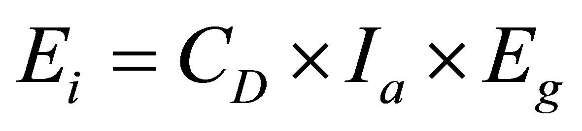 (3)
(3)
CD: Level in gas emissions (gTEQ/m3N)
N: Number of times measured Cn: Level in gas emissions the nth time (ngTEQ/m3N)
Ia: Amount incinerated (g/year)
Ic: Incineration capacity per hour (kg/h)
α: Hours operated per day (hours/day)
β: Days operated per year (days/year)
Ei: Amount emitted (gTEQ/year)
Eg: Amount of gas emissions per unit of amount incinerated (m3N/ton)
Among the incinerators which were evaluated, many report dioxin levels as being unmeasured. General waste incinerators which were evaluated by ADMER are largescale incinerators managed by local governments; therefore, none of these were among those that had not carried out measurements. However, all the incinerators required by the Law Concerning Special Measures against Dioxins to carry out independent measurements of dioxins once a year or more were evaluation targets of METILIS; therefore, besides general waste incinerators, medium-sized and small incinerators were also evaluation targets of METI-LIS. In particular, many small incinerators do not carry out measurements of dioxins, so it was necessary to estimate the emissions from these incinerators. Accordingly, incinerators which measure dioxins each year were classified in detail according to incineration capacity (the scale of the facilities of the incinerator), and as shown in Table 2, the average annual amount of emissions was estimated for each one. Then, after taking into consideration the number of days of operation per year and the number of hours of operation per day, based on Table 2, the amount of emissions per hour for incinerators that had not measured dioxins was calculated.
5. Evaluation of Entire Area of Region for Evaluation
5.1. Evaluation Targets
The evaluation targets in this section were all 41 largescale general waste incinerators which were total-continuous-type incinerators and were set up by local governments. The first reason for evaluating general waste incinerators was that they are large-scale incinerators which continue operating 24 hours a day throughout the year, and they have a long burning time and a high incineration capacity; therefore there is a high probability that they will have a large impact on the environment. The second reason was the height of their stacks. ADMER is basically suited to analyzing level distribution over a wide area. In wide-area level distribution analysis, sources for which there is a possibility that chemical substances will be dispersed further by the behavior of the atmosphere must be selected; therefore, incinerators with high stacks were focused on. Small incinerators with low stacks are influenced by high buildings in their surroundings, and disturbance of the dispersion of dioxins in the atmosphere occurs. However, the stacks of general waste incinerators are 40 m high or more; therefore, it is not necessary to take into account the influence of disturbances of the air stream which occur due to the surrounding buildings. For the evaluation target range, GIS was used, and a range of calculation of 90 km east-west and 50 km north-south was set, such that the entire area of the Tokyo Metropolis except for the islands was included, and level distribution was output using 500 m mesh units. As the period evaluated, the nine years from 2000 to 2008, for which source data was available, was selected.

Table 2. Average annual emissions of incinerators, classified by scale of facilities (gTEQ/year).
5.2. Calculation Conditions
1) Source data and chemical substance parameters For ADMER, necessary source data is source location (longitude and latitude), annual emissions and emissions elevation; necessary chemical substance parameters are decomposition coefficient, washout ratio, background levels and dry deposition velocity. Annual emissions were calculated using the calculation method in the previous section. In the ADMER analysis, only incinerators which operated continuously throughout the year were evaluated for each year. Incinerators whose operation was suspended, incinerators which were under construction or newly built, and incinerators which ceased operation during a year were excluded from that year’s analysis. Further, the value of the background level, which was necessary as a chemical substance parameter, was set as zero. Usually, concerning the background level, the atmospheric level of a region which is considered to receive hardly any impact from emission sources is used. However, in this study, the environmental risk from dioxins emitted from incinerators was evaluated; therefore, this was done to exclude the influence of sources other than incinerators, such as car exhaust gas and crematoriums.
2) Details of source data In order to fully understand the dioxin emissions from each incinerator during the evaluation period, annual emissions for each year were aggregated. These results are shown in Figure 2. As Figure 2 shows, incinerators whose total dioxin emissions for the nine year period were considerably higher than those of other incinerators were Setagaya Waste Incineration Plant, at 7.31 gTEQ/ year; Hino City Clean Center, at 6.96 gTEQ/year; Ota Waste Incineration Plant, at 5.82 gTEQ/year; and Shinagawa Waste Incineration Plant (formerly Oi Waste Incineration Plant), at 3.93 gTEQ/year.
5.3. Results and Consideration
1) Results of analysis by the atmospheric dispersion model (ADMER) and consideration
Figure 3 shows the results of analysis of atmospheric levels and deposition amounts during the evaluation period that were calculated using ADMER. It can be seen that atmospheric levels and deposition amounts were high particularly in the years 2000 and 2001, and decreased greatly from the year 2002 onwards. It can also be seen that different regions had high atmospheric levels and deposition amounts each year. It is necessary to understand the contamination levels in more detail in Hino City, Ota Ward and Setagaya Ward, which were highlevel regions in 2000 and 2001; however, the city and the wards were not identified as high-level regions in the year 2002 and beyond; therefore, it can be said that the amount of dioxin emissions from their general waste incinerators has been reduced. Meanwhile, from the year 2002 and onwards, Akiruno City is identified as a highlevel region more frequently than other regions, and there is variation in the dioxin emissions from its general waste incinerators each year; therefore, it can be said that compared to general waste incinerators in other regions, the emission levels of those in Akiruno City have not been improved. Comparing the 23 wards (the eastern part) with the Tama region (the western part) in the Tokyo Metropolis, from the year 2002 onwards, high-level regions were not identified in the wards of Tokyo; therefore, it can be said that the beneficial effects of the measures against dioxins implemented by the Clean Association of TOKYO23 were demonstrated.